
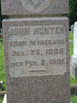
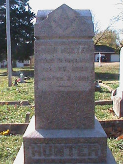
John Hunter
| Birth | : | 29 Dec 1825 Ireland |
| Death | : | 2 Feb 1901 Farmington, St. Francois County, Missouri, USA |
| Burial | : | Checkendon Churchyard, Checkendon, South Oxfordshire District, England |
| Coordinate | : | 51.5424461, -1.0449720 |
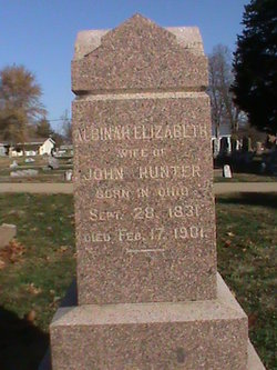
| Description | : | Mr. John Hunter was the husband of Albina Elizabeth (nee Meredith) Hunter. She herself passed away 13 days after John's death. In his obituary it mentions $2,000 worth of gold (in 1901 dollars) was found in his home. No mention of any children in his or his wife's obituary. View his obituary from 1901 with his wife's obituary immediately following his at web-link: John Hunter's obit. See another obituary for John Hunter with the mention of burial at this Masonic Cemetery at web link: John Hunter's 2nd obit. |
frequently asked questions (FAQ):
-
Where is John Hunter's memorial?
John Hunter's memorial is located at: Checkendon Churchyard, Checkendon, South Oxfordshire District, England.
-
When did John Hunter death?
John Hunter death on 2 Feb 1901 in Farmington, St. Francois County, Missouri, USA
-
Where are the coordinates of the John Hunter's memorial?
Latitude: 51.5424461
Longitude: -1.0449720
Family Members:
Spouse
Flowers:


Nearby Cemetories:
1. Checkendon Churchyard
Checkendon, South Oxfordshire District, England
Coordinate: 51.5424461, -1.0449720
2. St. John the Evangalist Churchyard
Stoke Row, South Oxfordshire District, England
Coordinate: 51.5510570, -1.0226630
3. Stoke Row Independant Chapel
Stoke Row, South Oxfordshire District, England
Coordinate: 51.5510570, -1.0226630
4. Stoke Row Independent Chapel Cemetery
Stoke Row, South Oxfordshire District, England
Coordinate: 51.5510570, -1.0226630
5. St. Leonard's Churchyard
Woodcote, South Oxfordshire District, England
Coordinate: 51.5348117, -1.0731299
6. Saint Bartholomew Chapelyard
Goring Heath, South Oxfordshire District, England
Coordinate: 51.5102184, -1.0545583
7. St. Pauls Highmoor Cross
Highmoor, South Oxfordshire District, England
Coordinate: 51.5532740, -0.9910110
8. St. Mary the Virgin Cemetery
Ipsden, South Oxfordshire District, England
Coordinate: 51.5674164, -1.0866686
9. Holy Trinity Churchyard
Nuffield, South Oxfordshire District, England
Coordinate: 51.5810040, -1.0378960
10. St. John the Baptist Churchyard
Whitchurch Hill, South Oxfordshire District, England
Coordinate: 51.5050469, -1.0824315
11. St. Bartholomew's Churchyard
Nettlebed, South Oxfordshire District, England
Coordinate: 51.5752360, -0.9936230
12. St. John the Baptist Churchyard
Kidmore End, South Oxfordshire District, England
Coordinate: 51.5085170, -0.9951240
13. All Saints Churchyard
Rotherfield Peppard, South Oxfordshire District, England
Coordinate: 51.5280531, -0.9725009
14. Kidmore End Cemetery
Kidmore End, South Oxfordshire District, England
Coordinate: 51.5071600, -0.9942160
15. Whitehill Burial Ground
Goring, South Oxfordshire District, England
Coordinate: 51.5214730, -1.1180180
16. St. Mary's Churchyard
North Stoke, South Oxfordshire District, England
Coordinate: 51.5714910, -1.1228080
17. St. Nicholas' Churchyard
Rotherfield Greys, South Oxfordshire District, England
Coordinate: 51.5351017, -0.9541395
18. St. Margaret's Churchyard
Mapledurham, South Oxfordshire District, England
Coordinate: 51.4850830, -1.0364690
19. Chapel of St Michael the Archangel
Mapledurham, South Oxfordshire District, England
Coordinate: 51.4849140, -1.0355910
20. St Andrew Churchyard
South Stoke, South Oxfordshire District, England
Coordinate: 51.5479065, -1.1377167
21. St Mary the Virgin Churchyard
Whitchurch-on-Thames, South Oxfordshire District, England
Coordinate: 51.4881640, -1.0868770
22. St. James's Churchyard
Bix and Assendon, South Oxfordshire District, England
Coordinate: 51.5610070, -0.9511270
23. St. Thomas of Canterbury Churchyard
Goring, South Oxfordshire District, England
Coordinate: 51.5221440, -1.1399970
24. St Mary the Virgin Cemetery
Purley on Thames, West Berkshire Unitary Authority, England
Coordinate: 51.4797100, -1.0402200