
| Memorials | : | 0 |
| Location | : | Purley on Thames, West Berkshire Unitary Authority, England |
| Coordinate | : | 51.4797100, -1.0402200 |
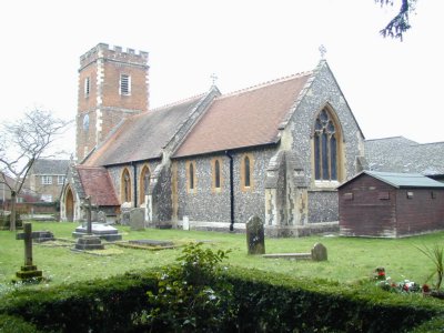
| Description | : | Although standing on an ancient site, Purley Church was completely rebuilt in 1870. Extensive enlargements added in 1983 include a multi-purpose hall and other facilities which cleverly open out directly from the nave arcading yet remain unobtrusive. They can be separated by curtains within and, without, are completely hidden from the main view of the building. Even, on the north side, the extension looks more like a small group of surroundings buildings than an actual attachment. The building's great treasure is its finely carved Norman font, of 1150, mostly showing interlaced arcading but also including an interesting mustachioed mask, probably representing... Read More |
frequently asked questions (FAQ):
-
Where is St Mary the Virgin Cemetery?
St Mary the Virgin Cemetery is located at Purley on Thames, West Berkshire Unitary Authority ,Berkshire ,England.
-
St Mary the Virgin Cemetery cemetery's updated grave count on graveviews.com?
0 memorials
-
Where are the coordinates of the St Mary the Virgin Cemetery?
Latitude: 51.4797100
Longitude: -1.0402200
Nearby Cemetories:
1. St. Margaret's Churchyard
Mapledurham, South Oxfordshire District, England
Coordinate: 51.4850830, -1.0364690
2. Chapel of St Michael the Archangel
Mapledurham, South Oxfordshire District, England
Coordinate: 51.4849140, -1.0355910
3. Saint Nicholas Churchyard
Sulham, West Berkshire Unitary Authority, England
Coordinate: 51.4632900, -1.0729000
4. St Mary the Virgin Churchyard
Whitchurch-on-Thames, South Oxfordshire District, England
Coordinate: 51.4881640, -1.0868770
5. Saint Bartholomew Chapelyard
Goring Heath, South Oxfordshire District, England
Coordinate: 51.5102184, -1.0545583
6. St. Laurence Churchyard
Tidmarsh, West Berkshire Unitary Authority, England
Coordinate: 51.4663800, -1.0873800
7. Pangbourne Cemetery
Pangbourne, West Berkshire Unitary Authority, England
Coordinate: 51.4805420, -1.0961030
8. St. John the Baptist Churchyard
Whitchurch Hill, South Oxfordshire District, England
Coordinate: 51.5050469, -1.0824315
9. St. Peter's Churchyard
Caversham, Reading Borough, England
Coordinate: 51.4686597, -0.9807669
10. Kidmore End Cemetery
Kidmore End, South Oxfordshire District, England
Coordinate: 51.5071600, -0.9942160
11. St. John the Baptist Churchyard
Kidmore End, South Oxfordshire District, England
Coordinate: 51.5085170, -0.9951240
12. Caversham Cemetery
Caversham, Reading Borough, England
Coordinate: 51.4745850, -0.9758020
13. Greyfriars Churchyard
Reading, Reading Borough, England
Coordinate: 51.4567920, -0.9764880
14. St. Mary's Churchyard
Reading, Reading Borough, England
Coordinate: 51.4544953, -0.9735278
15. St. Laurence Churchyard
Reading, Reading Borough, England
Coordinate: 51.4567474, -0.9686236
16. Holy Trinity Churchyard
Theale, West Berkshire Unitary Authority, England
Coordinate: 51.4367420, -1.0825640
17. St Giles Churchyard
Reading, Reading Borough, England
Coordinate: 51.4509510, -0.9704450
18. Reading Abbey Ruins
Reading, Reading Borough, England
Coordinate: 51.4563710, -0.9651130
19. Reading Prison Cemetery
Reading, Reading Borough, England
Coordinate: 51.4564910, -0.9641120
20. Saint Mark's Church
Englefield, West Berkshire Unitary Authority, England
Coordinate: 51.4435960, -1.1036540
21. Reading Cemetery and Crematorium
Caversham, Reading Borough, England
Coordinate: 51.4737690, -0.9546570
22. St. Leonard's Churchyard
Woodcote, South Oxfordshire District, England
Coordinate: 51.5348117, -1.0731299
23. All Saints Churchyard
Dunsden Green, South Oxfordshire District, England
Coordinate: 51.4917730, -0.9461650
24. Checkendon Churchyard
Checkendon, South Oxfordshire District, England
Coordinate: 51.5424461, -1.0449720