
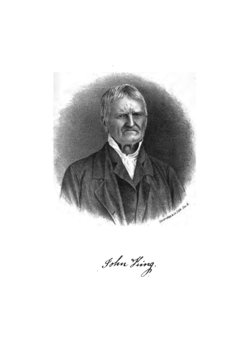


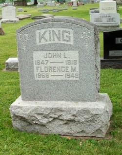
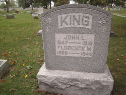
John L King
| Birth | : | 26 Sep 1847 Wayne County, Indiana, USA |
| Death | : | 21 Jun 1918 Centerville, Wayne County, Indiana, USA |
| Burial | : | Walnut Grove Cemetery, Delphos, Allen County, USA |
| Coordinate | : | 40.8300018, -84.2906036 |
| Plot | : | Section 13 |
| Description | : | John L. King was born in Wayne County, Ind., Sept. 26, 1847, the eldest son of Joseph and Sarah (Way) King, his mother a daughter of Seth Way, an early settler of Wayne County. He was educated in the district schools and Centreville College, obtaining a good business education. Feb. 22, 1882, he was married to Rena, daughter of Frank and Naomi (Lewis) Beverlin, of Jay County, Ind. He then settled on a farm of 160 acres, formerly known as the John Maxwell farm, where he is successfully engaged in farming and stock-raising. He is politically a Republican. He is... Read More |
frequently asked questions (FAQ):
-
Where is John L King's memorial?
John L King's memorial is located at: Walnut Grove Cemetery, Delphos, Allen County, USA.
-
When did John L King death?
John L King death on 21 Jun 1918 in Centerville, Wayne County, Indiana, USA
-
Where are the coordinates of the John L King's memorial?
Latitude: 40.8300018
Longitude: -84.2906036
Family Members:
Parent

Spouse
Siblings
Flowers:


Nearby Cemetories:
1. Walnut Grove Cemetery
Delphos, Allen County, USA
Coordinate: 40.8300018, -84.2906036
2. Hartshorn Cemetery
Allen County, USA
Coordinate: 40.8424988, -84.2908020
3. New Saint John's Catholic Cemetery
Delphos, Allen County, USA
Coordinate: 40.8451390, -84.2889380
4. King Cemetery
Marion Township, Allen County, USA
Coordinate: 40.8060989, -84.2869034
5. Saint John's Catholic Cemetery
Delphos, Allen County, USA
Coordinate: 40.8423620, -84.3319580
6. Pike Cemetery
Elida, Allen County, USA
Coordinate: 40.7947006, -84.2585983
7. Westside Cemetery
Delphos, Van Wert County, USA
Coordinate: 40.8452988, -84.3507996
8. Doner Cemetery
Elida, Allen County, USA
Coordinate: 40.7951330, -84.2277470
9. Carmen Cemetery
Gomer, Allen County, USA
Coordinate: 40.8531380, -84.2118660
10. Sharon Mennonite Cemetery
Elida, Allen County, USA
Coordinate: 40.7828080, -84.2332721
11. Hadding Cemetery
Gomer, Allen County, USA
Coordinate: 40.8319016, -84.2035980
12. Mount Calvary Cemetery
Fort Jennings, Putnam County, USA
Coordinate: 40.8986015, -84.3035965
13. Raabe Cemetery
Fort Jennings, Putnam County, USA
Coordinate: 40.8993988, -84.2789001
14. Saint Joseph Cemetery
Fort Jennings, Putnam County, USA
Coordinate: 40.9056015, -84.2928009
15. Lutheran Cemetery
Elida, Allen County, USA
Coordinate: 40.7877998, -84.2050018
16. Saint John the Baptist Catholic Cemetery
Landeck, Allen County, USA
Coordinate: 40.7999992, -84.3874969
17. Keirns Cemetery
Sugar Creek Township, Putnam County, USA
Coordinate: 40.8875008, -84.2181015
18. Salem Mennonite Cemetery
Elida, Allen County, USA
Coordinate: 40.8171220, -84.1851000
19. Greenlawn Cemetery
Elida, Allen County, USA
Coordinate: 40.7691994, -84.2024994
20. West Union Cemetery
Spencerville, Allen County, USA
Coordinate: 40.7574997, -84.3641968
21. Hartford Cemetery
Spencerville, Allen County, USA
Coordinate: 40.7386017, -84.3158035
22. Old Hartford Cemetery
Allen County, USA
Coordinate: 40.7371788, -84.3140564
23. Pike Run Cemetery
Gomer, Allen County, USA
Coordinate: 40.8432999, -84.1669006
24. Ottawa River Cemetery
Rimer, Putnam County, USA
Coordinate: 40.9061012, -84.2080994