
| Birth | : | 10 Aug 1861 Kane County, Illinois, USA |
| Death | : | 4 Sep 1945 Le Mars, Plymouth County, Iowa, USA |
| Burial | : | Church of Saint Mary, Blanchland, Northumberland Unitary Authority, England |
| Coordinate | : | 54.8484000, -2.0541000 |
| Plot | : | Block 10 Lot 75 |
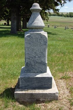
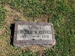
| Description | : | John Reeves Died Tuesday Morning Was Last Member Of Pioneer Family John H. Reeves, last of a pioneer Plymouth county family, died at the home of his daughter near Le Mars early Tuesday morning, September 4, at the age of 84 years. He was born in Kane county, Ill., April 10, 1861. Mr. Reeves came to Plymouth county in 1869 and lived in and around Le Mars the rest of his life. He farmed until 1915 and then worked at the carpenter trade until his health failed. Mr. Reeves married Harriett Osborne, October 17, 1883. Mrs. Reeves passed away August 23, 1915. Mr.... Read More |
frequently asked questions (FAQ):
-
Where is John Reeves's memorial?
John Reeves's memorial is located at: Church of Saint Mary, Blanchland, Northumberland Unitary Authority, England.
-
When did John Reeves death?
John Reeves death on 4 Sep 1945 in Le Mars, Plymouth County, Iowa, USA
-
Where are the coordinates of the John Reeves's memorial?
Latitude: 54.8484000
Longitude: -2.0541000
Family Members:
Parent
Spouse

Siblings
Children
Flowers:


Nearby Cemetories:
1. Church of Saint Mary
Blanchland, Northumberland Unitary Authority, England
Coordinate: 54.8484000, -2.0541000
2. St James Churchyard
Hunstanworth, Durham Unitary Authority, England
Coordinate: 54.8358650, -2.0807750
3. Winnowshill Friends' Meeting House
Healey, Northumberland Unitary Authority, England
Coordinate: 54.8706180, -2.0084840
4. St. Edmunds Churchyard
Edmundbyers, Durham Unitary Authority, England
Coordinate: 54.8440300, -1.9790400
5. All Saints Churchyard
Muggleswick, Durham Unitary Authority, England
Coordinate: 54.8442600, -1.9326700
6. Old Churchyard
Eastgate, Durham Unitary Authority, England
Coordinate: 54.7751710, -2.0933400
7. Rookhope Cemetery
Eastgate, Durham Unitary Authority, England
Coordinate: 54.7744000, -2.0916800
8. Saint Andrew’s Churchyard
Kiln Pit Hill, Northumberland Unitary Authority, England
Coordinate: 54.8916000, -1.9307000
9. St John's Churchyard
Healey, Northumberland Unitary Authority, England
Coordinate: 54.9200850, -1.9790940
10. St Matthew Churchyard
Consett, Durham Unitary Authority, England
Coordinate: 54.8040630, -1.9239040
11. Castleside Cemetery
Consett, Durham Unitary Authority, England
Coordinate: 54.8300800, -1.8834900
12. All Saints Churchyard
Eastgate, Durham Unitary Authority, England
Coordinate: 54.7445590, -2.0745270
13. Hindley and Broomley Churchyard
Broomley, Northumberland Unitary Authority, England
Coordinate: 54.9279100, -1.9339700
14. St Peter in the Forest
Allendale, Northumberland Unitary Authority, England
Coordinate: 54.8313100, -2.2350600
15. Moorside Cemetery
Consett, Durham Unitary Authority, England
Coordinate: 54.8409330, -1.8709330
16. Rowley Burial Ground
Consett, Durham Unitary Authority, England
Coordinate: 54.8262177, -1.8656499
17. Dilston Castle Chapelyard
Corbridge, Northumberland Unitary Authority, England
Coordinate: 54.9639270, -2.0393460
18. Blackhill Cemetery
Consett, Durham Unitary Authority, England
Coordinate: 54.8609100, -1.8451580
19. Corbridge Cemetery
Corbridge, Northumberland Unitary Authority, England
Coordinate: 54.9693100, -2.0263500
20. St. Peter's Churchyard
Bywell, Northumberland Unitary Authority, England
Coordinate: 54.9476800, -1.9249700
21. St Andrew's Churchyard
Bywell, Northumberland Unitary Authority, England
Coordinate: 54.9482010, -1.9258340
22. St Mary Roman Catholic Churchyard
Hexham, Northumberland Unitary Authority, England
Coordinate: 54.9697070, -2.1040520
23. St. Cuthbert's Churchyard
Allendale, Northumberland Unitary Authority, England
Coordinate: 54.8978260, -2.2545020
24. Hexham Abbey
Hexham, Northumberland Unitary Authority, England
Coordinate: 54.9715940, -2.1026190