
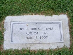
John Thomas Glover
| Birth | : | 24 Aug 1948 |
| Death | : | 16 Mar 2007 |
| Burial | : | Church of St Mary, Duddington, East Northamptonshire Borough, England |
| Coordinate | : | 52.5969190, -0.5432540 |
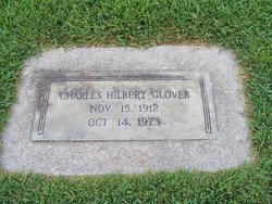
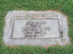
| Description | : | Obituary- Salisbury Post March 17, 2007 SALISBURY - Mr. John Thomas Glover, 58, died Friday March 16, 2007 at his residence. Born Aug. 24, 1948 in Salisbury, he was the son of the late Julia Rebecca Moose Glover and Charles Hilbert Glover, Sr. He was educated in the Salisbury City schools, graduated from Boyden High School, Class of 1966 and Catawba College. He received his EDS from Appalachian State University. Mr. Glover was a Principal of Chatham Central High School before retiring and was currently Assistant Principal of Salisbury High School. He was a former member and past president of... Read More |
frequently asked questions (FAQ):
-
Where is John Thomas Glover's memorial?
John Thomas Glover's memorial is located at: Church of St Mary, Duddington, East Northamptonshire Borough, England.
-
When did John Thomas Glover death?
John Thomas Glover death on 16 Mar 2007 in
-
Where are the coordinates of the John Thomas Glover's memorial?
Latitude: 52.5969190
Longitude: -0.5432540
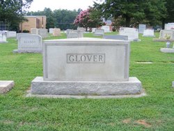
Family Members:
Parent
Siblings
Flowers:


Nearby Cemetories:
1. Church of St Mary
Duddington, East Northamptonshire Borough, England
Coordinate: 52.5969190, -0.5432540
2. Collyweston Cemetery
Collyweston, East Northamptonshire Borough, England
Coordinate: 52.6115580, -0.5319430
3. St. Andrew's Churchyard
Collyweston, East Northamptonshire Borough, England
Coordinate: 52.6151719, -0.5303754
4. Ketton Park Burial Ground
Ketton, Rutland Unitary Authority, England
Coordinate: 52.6240570, -0.5604330
5. Ketton St Mary the Virgin Churchyard
Ketton, Rutland Unitary Authority, England
Coordinate: 52.6274671, -0.5509559
6. Church of Saint John the Baptist
Wakerley, East Northamptonshire Borough, England
Coordinate: 52.5817323, -0.5929850
7. All Saints Churchyard
Kings Cliffe, East Northamptonshire Borough, England
Coordinate: 52.5622450, -0.5160080
8. St. Peter's Churchyard
Barrowden, Rutland Unitary Authority, England
Coordinate: 52.5888800, -0.6063600
9. All Saints Churchyard
Easton on the Hill, East Northamptonshire Borough, England
Coordinate: 52.6309146, -0.5075823
10. Kings Cliffe Cemetery
Kings Cliffe, East Northamptonshire Borough, England
Coordinate: 52.5605586, -0.5102005
11. St Mary the Virgin Churchyard
South Luffenham, Rutland Unitary Authority, England
Coordinate: 52.6067200, -0.6114100
12. Holy Trinity Churchyard
Blatherwycke, East Northamptonshire Borough, England
Coordinate: 52.5514375, -0.5646654
13. All Saints Churchyard
Tinwell, Rutland Unitary Authority, England
Coordinate: 52.6457410, -0.5144190
14. St. John The Baptist Church
North Luffenham, Rutland Unitary Authority, England
Coordinate: 52.6186570, -0.6211140
15. All Saints Churchyard
Laxton, East Northamptonshire Borough, England
Coordinate: 52.5535760, -0.5992450
16. St Mary the Virgin Churchyard
Morcott, Rutland Unitary Authority, England
Coordinate: 52.5967800, -0.6366200
17. St Leonard Churchyard
Apethorpe, East Northamptonshire Borough, England
Coordinate: 52.5495140, -0.4899340
18. All Saints Churchyard
Wittering, Peterborough Unitary Authority, England
Coordinate: 52.6058600, -0.4421600
19. St. Nicholas' Churchyard
Bulwick, East Northamptonshire Borough, England
Coordinate: 52.5376000, -0.5818000
20. St. Martin's Churchyard
Stamford, South Kesteven District, England
Coordinate: 52.6490200, -0.4773670
21. Saint John the Baptist Church
Stamford, South Kesteven District, England
Coordinate: 52.6517890, -0.4801320
22. All Saints Church
Stamford, South Kesteven District, England
Coordinate: 52.6522610, -0.4808400
23. St Mary's Churchyard
Stamford, South Kesteven District, England
Coordinate: 52.6514440, -0.4783930
24. St Mary the Virgin Churchyard
Edith Weston, Rutland Unitary Authority, England
Coordinate: 52.6379100, -0.6311100