
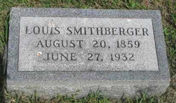
Louis Smithberger Sr.
| Birth | : | Aug 1860 Clayton County, Iowa, USA |
| Death | : | 27 Jun 1932 Stanton, Stanton County, Nebraska, USA |
| Burial | : | St Nicholas Churchyard, Sevenoaks, Sevenoaks District, England |
| Coordinate | : | 51.2673310, 0.1933100 |
| Plot | : | Lot G-128 |
| Description | : | He was reared in Iowa City, Iowa before he came to Stanton with his mother and stepfather in 1870. On Feb. 14, 1888, he and Minnie Zahn were married. He farmed and raised cattle. He served two terms in the Nebraska Legislature starting in 1901 as well aseight years as Stanton County Clerk. |
frequently asked questions (FAQ):
-
Where is Louis Smithberger Sr.'s memorial?
Louis Smithberger Sr.'s memorial is located at: St Nicholas Churchyard, Sevenoaks, Sevenoaks District, England.
-
When did Louis Smithberger Sr. death?
Louis Smithberger Sr. death on 27 Jun 1932 in Stanton, Stanton County, Nebraska, USA
-
Where are the coordinates of the Louis Smithberger Sr.'s memorial?
Latitude: 51.2673310
Longitude: 0.1933100
Family Members:
Spouse

Children
Flowers:


Nearby Cemetories:
1. St Nicholas Churchyard
Sevenoaks, Sevenoaks District, England
Coordinate: 51.2673310, 0.1933100
2. Sevenoaks War Memorial
Sevenoaks, Sevenoaks District, England
Coordinate: 51.2761078, 0.1927860
3. St Mary the Virgin Churchyard
Riverhead, Sevenoaks District, England
Coordinate: 51.2840040, 0.1707580
4. Greatness Park Cemetery
Sevenoaks, Sevenoaks District, England
Coordinate: 51.2906800, 0.2043260
5. St Peter and St Paul Churchyard
Seal, Sevenoaks District, England
Coordinate: 51.2907080, 0.2223010
6. St. Margaret's Churchyard
Underriver, Sevenoaks District, England
Coordinate: 51.2458191, 0.2291520
7. St Mary's
Dunton Green, Sevenoaks District, England
Coordinate: 51.2986100, 0.1632100
8. St. Lawrence Churchyard
Seal Chart, Sevenoaks District, England
Coordinate: 51.2742910, 0.2537250
9. St Mary Churchyard
Sundridge, Sevenoaks District, England
Coordinate: 51.2743360, 0.1292510
10. St. Bartholomew's Churchyard
Otford, Sevenoaks District, England
Coordinate: 51.3123700, 0.1916890
11. St Mary the Virgin Churchyard
Kemsing, Sevenoaks District, England
Coordinate: 51.3068670, 0.2310220
12. St. Mary's Churchyard
Ide Hill, Sevenoaks District, England
Coordinate: 51.2454500, 0.1277900
13. Chevening Parish Burial Ground
Chevening, Sevenoaks District, England
Coordinate: 51.2987450, 0.1356290
14. St Botolph Churchyard
Chevening, Sevenoaks District, England
Coordinate: 51.2987650, 0.1345180
15. Ightham Mote
Ightham, Tonbridge and Malling Borough, England
Coordinate: 51.2584610, 0.2695830
16. Hildenborough War Memorial
Hildenborough, Tonbridge and Malling Borough, England
Coordinate: 51.2175827, 0.2372410
17. St Martin Churchyard
Brasted, Sevenoaks District, England
Coordinate: 51.2794480, 0.1043810
18. St Giles Churchyard
Shipbourne, Tonbridge and Malling Borough, England
Coordinate: 51.2471700, 0.2786090
19. St John the Evangelist Churchyard
Hildenborough, Tonbridge and Malling Borough, England
Coordinate: 51.2174100, 0.2391660
20. St Peter Churchyard
Ightham, Tonbridge and Malling Borough, England
Coordinate: 51.2891680, 0.2858450
21. Plaxtol Parish Churchyard
Plaxtol, Tonbridge and Malling Borough, England
Coordinate: 51.2593498, 0.2945710
22. St Mary's Churchyard Woodlands
West Kingsdown, Sevenoaks District, England
Coordinate: 51.3233700, 0.2428600
23. Plaxtol War Memorial
Plaxtol, Tonbridge and Malling Borough, England
Coordinate: 51.2592888, 0.2948450
24. St. Peter and St. Paul's Churchyard
Shoreham, Sevenoaks District, England
Coordinate: 51.3330170, 0.1844590