
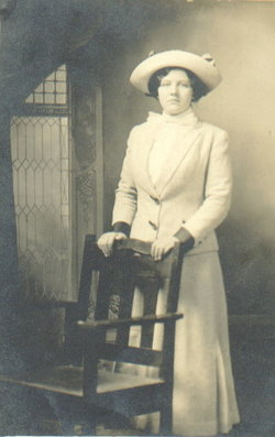


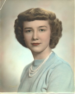
Louise K Andreesen Gerdes
| Birth | : | 7 Nov 1891 Leerhafe, Landkreis Wittmund, Lower Saxony (Niedersachsen), Germany |
| Death | : | 7 Feb 1987 Anamosa, Jones County, Iowa, USA |
| Burial | : | St Chad Churchyard, Lichfield, Lichfield District, England |
| Coordinate | : | 52.6895810, -1.8209640 |
| Plot | : | new 11 |
| Inscription | : | wf of Gerhard |
| Description | : | Louise Gerdes Louise Gerdes, 95, of Anamosa died early Feb 7, 1987, at the Anamosa Care Center. Gretke Katharine Luise Andreesen was born Nov 7, 1891, in Leerhafe, Germany; the daughter of Henry and Margaret Folkers Andreesen. She received her education in the schools in Germany. Louise and her family moved to the United States when she was 14 years old. She married Gerhard William Gerdes May 7, 1913, at Wayne Zion Lutheran Church. The couple farmed all their married life in Fairview and Cass townships. Mr. Gerdes died in... Read More |
frequently asked questions (FAQ):
-
Where is Louise K Andreesen Gerdes's memorial?
Louise K Andreesen Gerdes's memorial is located at: St Chad Churchyard, Lichfield, Lichfield District, England.
-
When did Louise K Andreesen Gerdes death?
Louise K Andreesen Gerdes death on 7 Feb 1987 in Anamosa, Jones County, Iowa, USA
-
Where are the coordinates of the Louise K Andreesen Gerdes's memorial?
Latitude: 52.6895810
Longitude: -1.8209640
Family Members:
Parent

Spouse
Siblings
Children
Flowers:


Nearby Cemetories:
1. St Chad Churchyard
Lichfield, Lichfield District, England
Coordinate: 52.6895810, -1.8209640
2. St Michael's Churchyard
Lichfield, Lichfield District, England
Coordinate: 52.6834590, -1.8182370
3. Lichfield Cathedral
Lichfield, Lichfield District, England
Coordinate: 52.6855650, -1.8304500
4. Grey Friars Churchyard
Lichfield, Lichfield District, England
Coordinate: 52.6829030, -1.8282720
5. Stychbrook Cemetery
Lichfield District, England
Coordinate: 52.6998096, -1.8347392
6. Christ Church Churchyard
Lichfield, Lichfield District, England
Coordinate: 52.6812150, -1.8405800
7. St. Giles' Churchyard
Whittington, Lichfield District, England
Coordinate: 52.6723850, -1.7677160
8. St. John's Churchyard
Wall, Lichfield District, England
Coordinate: 52.6575100, -1.8553200
9. Saint Stephen Churchyard
Fradley, Lichfield District, England
Coordinate: 52.7183456, -1.7686180
10. St Matthew's Hospital Burial Ground
Burntwood, Lichfield District, England
Coordinate: 52.6804500, -1.8937800
11. Christchurch Cemetery
Burntwood, Lichfield District, England
Coordinate: 52.6787639, -1.8969201
12. St. James the Great Churchyard
Longdon, Lichfield District, England
Coordinate: 52.7250710, -1.8800360
13. St Peter's Churchyard
Elford, Lichfield District, England
Coordinate: 52.6928330, -1.7274120
14. St Mary the Virgin New Churchyard
Weeford, Lichfield District, England
Coordinate: 52.6330806, -1.7923083
15. St. Mary the Virgin Churchyard
Weeford, Lichfield District, England
Coordinate: 52.6322300, -1.7923200
16. All Saints Churchyard
Alrewas, Lichfield District, England
Coordinate: 52.7347941, -1.7530332
17. National Memorial Arboretum
Alrewas, Lichfield District, England
Coordinate: 52.7274040, -1.7324890
18. Christ Church Gentleshaw
Rugeley, Cannock Chase District, England
Coordinate: 52.7050151, -1.9264458
19. St Chad's
Tamworth Borough, England
Coordinate: 52.6433000, -1.7418000
20. St John the Baptist Churchyard
Armitage with Handsacre, Lichfield District, England
Coordinate: 52.7458638, -1.8851159
21. Chase and District Memorial Park
Burntwood, Lichfield District, England
Coordinate: 52.6817140, -1.9339150
22. St John's Church Cemetery
Burntwood, Lichfield District, England
Coordinate: 52.6901000, -1.9349300
23. Hopwas Cemetery
Tamworth, Tamworth Borough, England
Coordinate: 52.6417200, -1.7362600
24. St Leonard's Church
Wychnor, East Staffordshire Borough, England
Coordinate: 52.7420071, -1.7394617