


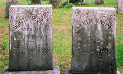
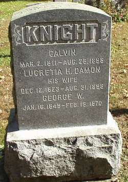
Lucretia Hamilton Damon Knight
| Birth | : | 12 Dec 1823 Chesterfield, Hampshire County, Massachusetts, USA |
| Death | : | 31 Aug 1898 Whately, Franklin County, Massachusetts, USA |
| Burial | : | St Mary's Newhouse, Barton, City of Preston, England |
| Coordinate | : | 53.8205240, -2.7406500 |
| Description | : | Calvin Knight and his wife Lucretia Hamilton (Damon) Knight died at their residence in Whately, Franklin Co, MA, three days apart from each other of "Typhoid Dysentry" Edit based on "Massachusetts, U.S., Death Records, 1841-1915" - _Pre 1903 - 1898 - Scan 642 - Deaths Registered in the Town of Whately, Page 675, Nos. 8 & 9. |
frequently asked questions (FAQ):
-
Where is Lucretia Hamilton Damon Knight's memorial?
Lucretia Hamilton Damon Knight's memorial is located at: St Mary's Newhouse, Barton, City of Preston, England.
-
When did Lucretia Hamilton Damon Knight death?
Lucretia Hamilton Damon Knight death on 31 Aug 1898 in Whately, Franklin County, Massachusetts, USA
-
Where are the coordinates of the Lucretia Hamilton Damon Knight's memorial?
Latitude: 53.8205240
Longitude: -2.7406500
Family Members:
Parent
Spouse
Siblings

Children


Flowers:


Nearby Cemetories:
1. St Mary's Newhouse
Barton, City of Preston, England
Coordinate: 53.8205240, -2.7406500
2. St. Lawrence Churchyard
Barton, City of Preston, England
Coordinate: 53.8289213, -2.7366654
3. Saint Anne's Church
Woodplumpton, City of Preston, England
Coordinate: 53.8038130, -2.7621940
4. St. John Baptist Churchyard
Broughton-in-Amounderness, City of Preston, England
Coordinate: 53.8033700, -2.7170400
5. St. Hilda's Churchyard
Bilsborrow, Wyre Borough, England
Coordinate: 53.8522170, -2.7420090
6. St Andrew George Haydock Roman Catholic Churchyard
Cottam, City of Preston, England
Coordinate: 53.7879280, -2.7591570
7. St. Mary the Virgin Churchyard
Goosnargh, City of Preston, England
Coordinate: 53.8266470, -2.6707030
8. St. Mary's Churchyard
Preston, City of Preston, England
Coordinate: 53.8010830, -2.6779600
9. Whittingham Hospital Cemetery
Goosnargh, City of Preston, England
Coordinate: 53.8208401, -2.6613468
10. St. Peters Churchyard
Inskip with Sowerby, Wyre Borough, England
Coordinate: 53.8347100, -2.8175200
11. Christ Church Churchyard
Fulwood, City of Preston, England
Coordinate: 53.7771920, -2.7028700
12. St. Andrew's Churchyard
Ashton-on-Ribble, City of Preston, England
Coordinate: 53.7687030, -2.7359180
13. Inskip Baptist Churchyard
Inskip with Sowerby, Wyre Borough, England
Coordinate: 53.8353150, -2.8299610
14. St Thomas Churchyard
Claughton-on-Brock, Wyre Borough, England
Coordinate: 53.8752030, -2.7199160
15. St. Mary's Churchyard
Lea, City of Preston, England
Coordinate: 53.7733810, -2.7942770
16. St Walburge's RC Church
Preston, City of Preston, England
Coordinate: 53.7629690, -2.7149620
17. Saint Peter Churchyard
Preston, City of Preston, England
Coordinate: 53.7634100, -2.7080700
18. Church of St James
Goosnargh, City of Preston, England
Coordinate: 53.8657750, -2.6719410
19. St. Ignatius RC Churchyard
Preston, City of Preston, England
Coordinate: 53.7635270, -2.6965870
20. St. Michael’s Churchyard
St Michael's on Wyre, Wyre Borough, England
Coordinate: 53.8628050, -2.8195430
21. St. John the Evangelist Churchyard
Clifton, Fylde Borough, England
Coordinate: 53.7758600, -2.8158500
22. Christ Churchyard
Treales, Fylde Borough, England
Coordinate: 53.8045970, -2.8440710
23. Holy Trinity
Preston, City of Preston, England
Coordinate: 53.7613030, -2.7030580
24. Grey Friars' Church
Preston, City of Preston, England
Coordinate: 53.7601480, -2.7084600