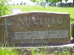
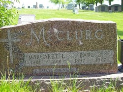
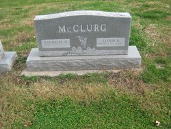
Margaret Lurene Shannon McClurg
| Birth | : | 13 Jul 1901 Maryville, Nodaway County, Missouri, USA |
| Death | : | 21 Jun 1991 Maryville, Nodaway County, Missouri, USA |
| Burial | : | West Fork Cemetery, West Fork, Washington County, USA |
| Coordinate | : | 35.9324989, -94.1932983 |
| Plot | : | Central B (5), Row 16 |
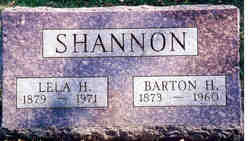
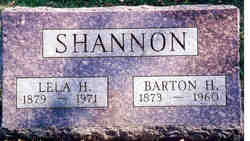
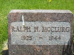
| Description | : | Daughter of Barton and Lela Howard Shannon. Margaret McClurg, 89, Maryville, died Friday, June 21, 1991, at Maryville Health Care Center. Born July 13, 1901 near Maryville to Barton Holt and Lela Howard Shannon, she was a homemaker. She graduated from Pickering High School in 1920, and lived a lifetime in this area. She was a member of First Christian Church, CFW, Bloomfield Needlework Club, World War I Barracks Auxiliary and Mother's Club, all of Maryville. She married Earl Robert McClurg on March 5, 1921 in Maryville. McClurg was preceded in death by her husband and a son, Ralph, in... Read More |
frequently asked questions (FAQ):
-
Where is Margaret Lurene Shannon McClurg's memorial?
Margaret Lurene Shannon McClurg's memorial is located at: West Fork Cemetery, West Fork, Washington County, USA.
-
When did Margaret Lurene Shannon McClurg death?
Margaret Lurene Shannon McClurg death on 21 Jun 1991 in Maryville, Nodaway County, Missouri, USA
-
Where are the coordinates of the Margaret Lurene Shannon McClurg's memorial?
Latitude: 35.9324989
Longitude: -94.1932983
Family Members:
Parent
Spouse
Children
Flowers:
Nearby Cemetories:
1. West Fork Cemetery
West Fork, Washington County, USA
Coordinate: 35.9324989, -94.1932983
2. John A Rutherford - Martin Cemetery
Washington County, USA
Coordinate: 35.9513950, -94.2011490
3. Bryant Cemetery
Washington County, USA
Coordinate: 35.9514250, -94.2011060
4. Karnes Cemetery
West Fork, Washington County, USA
Coordinate: 35.9084930, -94.1865082
5. Campbell Church Cemetery
West Fork, Washington County, USA
Coordinate: 35.9583015, -94.1903000
6. John Westley Rutherford Cemetery
Washington County, USA
Coordinate: 35.9486760, -94.1669400
7. Reed Cemetery
West Fork, Washington County, USA
Coordinate: 35.9630800, -94.2051510
8. Friendship Cemetery
West Fork, Washington County, USA
Coordinate: 35.9043740, -94.2217230
9. Greenland Cemetery
Greenland, Washington County, USA
Coordinate: 35.9643900, -94.1696800
10. Union Star Cemetery
West Fork, Washington County, USA
Coordinate: 35.8922005, -94.2031021
11. Barron Cemetery
Greenland, Washington County, USA
Coordinate: 35.9599440, -94.2355570
12. Dale Family Cemetery
Hogeye, Washington County, USA
Coordinate: 35.9651640, -94.2322680
13. Carney Cemetery
Washington County, USA
Coordinate: 35.9242710, -94.2484530
14. Mineral Springs Cemetery
West Fork, Washington County, USA
Coordinate: 35.9264980, -94.1349980
15. Union Cemetery
Greenland, Washington County, USA
Coordinate: 35.9805984, -94.1735992
16. Baptist Ford Cemetery
Greenland, Washington County, USA
Coordinate: 35.9803160, -94.1724660
17. Phillips Cemetery
Hogeye, Washington County, USA
Coordinate: 35.9119760, -94.2556360
18. Stevenson Leach Cemetery
Prairie Grove, Washington County, USA
Coordinate: 35.9586000, -94.2524000
19. Boone Pioneer Cemetery
Greenland, Washington County, USA
Coordinate: 35.9880050, -94.1916090
20. Black Oak Cemetery
Greenland, Washington County, USA
Coordinate: 35.9815480, -94.2291780
21. Burris Cemetery
Washington County, USA
Coordinate: 35.8935000, -94.2482650
22. Holcomb Cemetery
West Fork, Washington County, USA
Coordinate: 35.8954065, -94.2519087
23. Billingsley Cemetery
West Fork, Washington County, USA
Coordinate: 35.9132996, -94.2716980
24. Low Gap Cemetery
West Fork, Washington County, USA
Coordinate: 35.8658218, -94.2063904

