

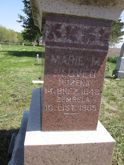
Maria M. Peterka Nedved
| Birth | : | 14 Mar 1848 Czech Republic |
| Death | : | 10 Nov 1909 Yankton County, South Dakota, USA |
| Burial | : | St. Peter and St. Paul's Churchyard, Belton, South Kesteven District, England |
| Coordinate | : | 52.9451000, -0.6177000 |
| Plot | : | Sec. 2 ~ Grave 1 |
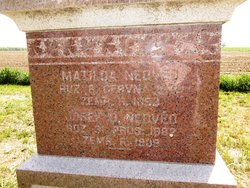
| Description | : | Rozena 14 Brez 1848 – Zemrela 10 List 1909; She's on the side of the stone that she shares with Matilda & Josef D. & Jos. J. is on the other side. Contributed by Deb Cap |
frequently asked questions (FAQ):
-
Where is Maria M. Peterka Nedved's memorial?
Maria M. Peterka Nedved's memorial is located at: St. Peter and St. Paul's Churchyard, Belton, South Kesteven District, England.
-
When did Maria M. Peterka Nedved death?
Maria M. Peterka Nedved death on 10 Nov 1909 in Yankton County, South Dakota, USA
-
Where are the coordinates of the Maria M. Peterka Nedved's memorial?
Latitude: 52.9451000
Longitude: -0.6177000
Family Members:
Spouse
Children


Flowers:


Nearby Cemetories:
1. St. Peter and St. Paul's Churchyard
Belton, South Kesteven District, England
Coordinate: 52.9451000, -0.6177000
2. St Marys Churchyard
Syston, South Kesteven District, England
Coordinate: 52.9578420, -0.6172940
3. St John the Evangelist Churchyard
Manthorpe, South Kesteven District, England
Coordinate: 52.9306320, -0.6323160
4. St Nicholas Churchyard
Barkston, South Kesteven District, England
Coordinate: 52.9629960, -0.6129380
5. St John the Baptist Churchyard
Londonthorpe, South Kesteven District, England
Coordinate: 52.9312060, -0.5837350
6. Manthorpe Road Old Cemetery
Grantham, South Kesteven District, England
Coordinate: 52.9173900, -0.6409900
7. St Sebastian Churchyard
Great Gonerby, South Kesteven District, England
Coordinate: 52.9329260, -0.6657700
8. St. Wulfram Churchyard
Grantham, South Kesteven District, England
Coordinate: 52.9148180, -0.6408520
9. Grantham Cemetery and Crematorium
Grantham, South Kesteven District, England
Coordinate: 52.9095320, -0.6326120
10. St. Wilfrid Churchyard
Honington, South Kesteven District, England
Coordinate: 52.9795600, -0.5965700
11. St. Nicholas Churchyard
Carlton Scroop, South Kesteven District, England
Coordinate: 52.9940290, -0.5895960
12. All Saints Churchyard
Barrowby, South Kesteven District, England
Coordinate: 52.9186420, -0.6946810
13. All Saints Churchyard
Hougham, South Kesteven District, England
Coordinate: 52.9878240, -0.6806910
14. St. Mary Magdalene Churchyard
Old Somerby, South Kesteven District, England
Coordinate: 52.8944900, -0.5672830
15. St. Martin Churchyard
Ancaster, South Kesteven District, England
Coordinate: 52.9804810, -0.5377820
16. Ancaster Cemetery
Ancaster, South Kesteven District, England
Coordinate: 52.9814450, -0.5387892
17. All Saints Churchyard
Hough-on-the-Hill, South Kesteven District, England
Coordinate: 53.0069700, -0.6255100
18. St Nicholas Churchyard
Normanton, South Kesteven District, England
Coordinate: 53.0051390, -0.5874570
19. St James Churchyard
Allington, South Kesteven District, England
Coordinate: 52.9525695, -0.7245301
20. St. Guthlac Churchyard
Little Ponton, South Kesteven District, England
Coordinate: 52.8796100, -0.6271200
21. St. Lawrence Churchyard
Sedgebrook, South Kesteven District, England
Coordinate: 52.9329460, -0.7256530
22. St Andrew Churchyard
Kelby, North Kesteven District, England
Coordinate: 52.9608000, -0.5074000
23. St. Andrew's Churchyard
South Kesteven District, England
Coordinate: 52.9608000, -0.5074000
24. St Peter Churchyard
Foston, South Kesteven District, England
Coordinate: 52.9771630, -0.7227360