
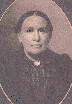
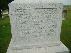
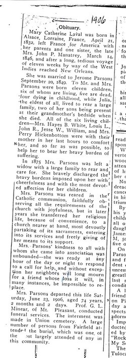
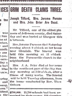
Marie Catherine “Mary” Laval Parsons
| Birth | : | 21 Apr 1832 France |
| Death | : | 23 Jun 1906 Jefferson County, Iowa, USA |
| Burial | : | Waiuku Cemetery, Waiuku, Auckland Council, New Zealand |
| Coordinate | : | -37.2612630, 174.7346520 |
| Description | : | Daughter of Jerome Laval/Lavel and Marie Julienne Keller Laval/Level. There are some discrepancies in various Parsons family history group sheets as to the correct spelling of her maiden name. This memorial will use the Laval spelling as it is most likely to be the correct spelling. Her first name is believed to be "Marie" as the proper given name. The "Mary" found on her headstone inscription and in her obituary are so noted as well. Wife of Jerome Parsons, married September 20, 1849 in Jefferson County, Iowa. Children: Mary Julia Parsons (1850-1896) Diana Parsons (White) (1855-1937) Louis Lavell/Lavelle Parsons (1859-1947) John Rust Parsons... Read More |
frequently asked questions (FAQ):
-
Where is Marie Catherine “Mary” Laval Parsons's memorial?
Marie Catherine “Mary” Laval Parsons's memorial is located at: Waiuku Cemetery, Waiuku, Auckland Council, New Zealand.
-
When did Marie Catherine “Mary” Laval Parsons death?
Marie Catherine “Mary” Laval Parsons death on 23 Jun 1906 in Jefferson County, Iowa, USA
-
Where are the coordinates of the Marie Catherine “Mary” Laval Parsons's memorial?
Latitude: -37.2612630
Longitude: 174.7346520
Family Members:
Spouse

Children

Flowers:


Nearby Cemetories:
1. Waiuku Cemetery
Waiuku, Auckland Council, New Zealand
Coordinate: -37.2612630, 174.7346520
2. Tahuna Pa Road Urupā
Waiuku, Auckland Council, New Zealand
Coordinate: -37.2290900, 174.7080100
3. Waipipi Cemetery
Awhitu, Auckland Council, New Zealand
Coordinate: -37.2124964, 174.6845550
4. Mauku Cemetery
Mauku, Auckland Council, New Zealand
Coordinate: -37.2011420, 174.8109100
5. St Brides Church of England Cemetery
Mauku, Auckland Council, New Zealand
Coordinate: -37.2011260, 174.8120370
6. Tekohanga Urupā
Port Waikato, Waikato District, New Zealand
Coordinate: -37.3314940, 174.8085230
7. Mauku Historical Cemetery
Mauku, Auckland Council, New Zealand
Coordinate: -37.1743690, 174.7951870
8. Manutahi Urupā
Port Waikato, Waikato District, New Zealand
Coordinate: -37.3337939, 174.8210091
9. Kohekohe Cemetery
Pollok, Auckland Council, New Zealand
Coordinate: -37.1797380, 174.6508930
10. Waiau Pa Cemetery
Waiau Pa, Auckland Council, New Zealand
Coordinate: -37.1327190, 174.7573970
11. Oraeroa Urupā
Port Waikato, Waikato District, New Zealand
Coordinate: -37.3913670, 174.7257830
12. Pukekohe Public Cemetery
Pukekohe, Auckland Council, New Zealand
Coordinate: -37.2106400, 174.8974900
13. Pollok Cemetery
Pollok, Auckland Council, New Zealand
Coordinate: -37.1469760, 174.6257190
14. Pukekohe Catholic Cemetery
Pukekohe, Auckland Council, New Zealand
Coordinate: -37.1951510, 174.9014640
15. Onewhero Cemetery
Onewhero, Waikato District, New Zealand
Coordinate: -37.3158900, 174.9104900
16. Heights Park Cemetery
Paerata, Auckland Council, New Zealand
Coordinate: -37.1781928, 174.8938836
17. Alexandra Redoubt Cemetery
Tuakau, Waikato District, New Zealand
Coordinate: -37.2858200, 174.9419600
18. Tuakau Cemetery
Tuakau, Waikato District, New Zealand
Coordinate: -37.2844420, 174.9465660
19. Pukekohe East Cemetery
Pukekohe East, Auckland Council, New Zealand
Coordinate: -37.1883500, 174.9459000
20. Awhitu Central Cemetery
Awhitu Central, Auckland Council, New Zealand
Coordinate: -37.0956340, 174.5813100
21. Bombay Presbyterian Church Cemetery
Bombay, Auckland Council, New Zealand
Coordinate: -37.1790700, 174.9826900
22. St. Peter's in the Forest Anglican Cemetery
Bombay, Auckland Council, New Zealand
Coordinate: -37.1869100, 174.9914100
23. Pokeno Old Soldiers Cemetery
Pokeno, Waikato District, New Zealand
Coordinate: -37.2386120, 175.0094760
24. Pokeno Cemetery
Pokeno, Waikato District, New Zealand
Coordinate: -37.2364600, 175.0215400