

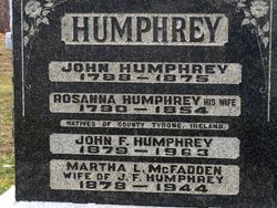
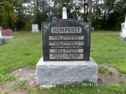
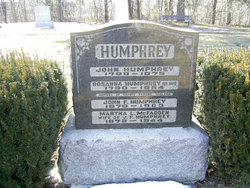
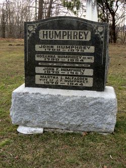
Martha Louise McFadden Humphrey
| Birth | : | 19 Jul 1875 Ireland |
| Death | : | 3 Jan 1944 Brampton, Peel Regional Municipality, Ontario, Canada |
| Burial | : | Reichswald Forest War Cemetery, Kleve, Kreis Kleve, Germany |
| Coordinate | : | 51.7406464, 6.0824242 |
frequently asked questions (FAQ):
-
Where is Martha Louise McFadden Humphrey's memorial?
Martha Louise McFadden Humphrey's memorial is located at: Reichswald Forest War Cemetery, Kleve, Kreis Kleve, Germany.
-
When did Martha Louise McFadden Humphrey death?
Martha Louise McFadden Humphrey death on 3 Jan 1944 in Brampton, Peel Regional Municipality, Ontario, Canada
-
Where are the coordinates of the Martha Louise McFadden Humphrey's memorial?
Latitude: 51.7406464
Longitude: 6.0824242
Family Members:
Spouse
Children
Flowers:


Nearby Cemetories:
1. Reichswald Forest War Cemetery
Kleve, Kreis Kleve, Germany
Coordinate: 51.7406464, 6.0824242
2. Friedhof Nütterden
Kranenburg, Kreis Kleve, Germany
Coordinate: 51.7904340, 6.0629380
3. Saint Vincentius Kath. Asperden
Asperden, Kreis Kleve, Germany
Coordinate: 51.6929200, 6.1134800
4. Ottersum Roman Catholic Cemetery
Ottersum, Gennep Municipality, Netherlands
Coordinate: 51.7020800, 5.9824600
5. Milsbeek War Cemetery
Milsbeek, Gennep Municipality, Netherlands
Coordinate: 51.7254400, 5.9511900
6. Saint Bonifacius
Niel, Kreis Kleve, Germany
Coordinate: 51.8261350, 6.0182900
7. Friedhof Griethausen
Sinstorf, Harburg, Germany
Coordinate: 51.8213100, 6.1664800
8. Groesbeek Canadian War Cemetery and Memorial
Groesbeek, Berg en Dal Municipality, Netherlands
Coordinate: 51.7982900, 5.9321900
9. Afferden Begraafplaats
Afferden, Bergen Municipality, Netherlands
Coordinate: 51.6349100, 6.0131700
10. Friedhof Bimmen
Bimmen, Kreis Kleve, Germany
Coordinate: 51.8588737, 6.0695000
11. Tolkamer General Cemetery
Tolkamer, Rijnwaarden Municipality, Netherlands
Coordinate: 51.8610900, 6.0814200
12. Mook-en-Middelaar Roman Catholic Churchyard
Mook, Mook en Middelaar Municipality, Netherlands
Coordinate: 51.7531600, 5.8854200
13. Mook War Cemetery
Mook, Mook en Middelaar Municipality, Netherlands
Coordinate: 51.7541200, 5.8854300
14. Städtischer Friedhof
Kalkar, Kreis Kleve, Germany
Coordinate: 51.7388423, 6.2880522
15. Boxmeer Roman Catholic Churchyard
Boxmeer, Boxmeer Municipality, Netherlands
Coordinate: 51.6427910, 5.9497830
16. Jüdischer Friedhof
Kalkar, Kreis Kleve, Germany
Coordinate: 51.7405871, 6.2954199
17. Heilig Landstichting Burial Park
Heilig Landstichting, Berg en Dal Municipality, Netherlands
Coordinate: 51.8173600, 5.8907100
18. Friedhof Emmerich
Emmerich, Kreis Kleve, Germany
Coordinate: 51.8393300, 6.2479200
19. Jüdischer Friedhof
Emmerich, Kreis Kleve, Germany
Coordinate: 51.8370156, 6.2535498
20. Herwen Roman Catholic Churchyard
Herwen, Rijnwaarden Municipality, Netherlands
Coordinate: 51.8844900, 6.1035900
21. Begraafplaats Het Witte Kerkje
Ubbergen, Berg en Dal Municipality, Netherlands
Coordinate: 51.8361166, 5.9018954
22. Joodse Begraafplaats
Nijmegen, Nijmegen Municipality, Netherlands
Coordinate: 51.8308300, 5.8836000
23. Joodse Begraafplaats
Vierlingsbeek, Boxmeer Municipality, Netherlands
Coordinate: 51.5961600, 6.0010200
24. Rustoord Cemetery
Nijmegen, Nijmegen Municipality, Netherlands
Coordinate: 51.8305100, 5.8808600