
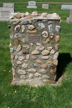
Mary Alice Graves
| Birth | : | 1888 |
| Death | : | 1935 |
| Burial | : | All Saints Church, Clive, Shropshire Unitary Authority, England |
| Coordinate | : | 52.8116250, -2.7212930 |
frequently asked questions (FAQ):
-
Where is Mary Alice Graves's memorial?
Mary Alice Graves's memorial is located at: All Saints Church, Clive, Shropshire Unitary Authority, England.
-
When did Mary Alice Graves death?
Mary Alice Graves death on 1935 in
-
Where are the coordinates of the Mary Alice Graves's memorial?
Latitude: 52.8116250
Longitude: -2.7212930
Family Members:
Parent

Flowers:


Nearby Cemetories:
1. All Saints Church
Clive, Shropshire Unitary Authority, England
Coordinate: 52.8116250, -2.7212930
2. St. Mary Magdalene Church
Hadnall, Shropshire Unitary Authority, England
Coordinate: 52.7759670, -2.7100180
3. Bomere Heath Methodist Church Burial Ground
Bomere Heath, Shropshire Unitary Authority, England
Coordinate: 52.7734260, -2.7833720
4. St John the Baptist Churchyard
Albrighton, Shropshire Unitary Authority, England
Coordinate: 52.7572400, -2.7462600
5. St. Mary's Churchyard
Edstaston, Shropshire Unitary Authority, England
Coordinate: 52.8830727, -2.7182040
6. St Peter and St Paul Churchyard
Fitz, Shropshire Unitary Authority, England
Coordinate: 52.7553657, -2.8182247
7. All Saints Churchyard
Baschurch, Shropshire Unitary Authority, England
Coordinate: 52.7913710, -2.8586210
8. St. Simon and St. Jude Churchyard
Cockshutt, Shropshire Unitary Authority, England
Coordinate: 52.8577297, -2.8412706
9. St. Michael & All Angels Churchyard
High Ercall, Telford and Wrekin Unitary Authority, England
Coordinate: 52.7521000, -2.6026400
10. St Luke's Churchyard
Hodnet, Shropshire Unitary Authority, England
Coordinate: 52.8536780, -2.5772160
11. Bicton Cemetery
Bicton, Shropshire Unitary Authority, England
Coordinate: 52.7284870, -2.8183830
12. Rodington Cemetery
Rodington, Telford and Wrekin Unitary Authority, England
Coordinate: 52.7273200, -2.6148100
13. Coton Primitive Methodist Chapel
Cotonwood, Shropshire Unitary Authority, England
Coordinate: 52.9191890, -2.6926830
14. St Michael Churchyard
Waters Upton, Telford and Wrekin Unitary Authority, England
Coordinate: 52.7713210, -2.5439270
15. St. Michael Churchyard
Ford, Shropshire Unitary Authority, England
Coordinate: 52.7184248, -2.8715080
16. St Mary the Virgin Parish Church
Hordley, Shropshire Unitary Authority, England
Coordinate: 52.8713670, -2.9208050
17. St. Eata's Churchyard
Atcham, Shropshire Unitary Authority, England
Coordinate: 52.6785350, -2.6803958
18. St Michael & All Angels
Childs Ercall, Shropshire Unitary Authority, England
Coordinate: 52.8222524, -2.4975524
19. Saint Mary's Churchyard
Ellesmere, Shropshire Unitary Authority, England
Coordinate: 52.9075740, -2.8894550
20. Ellesmere Cemetery
Ellesmere, Shropshire Unitary Authority, England
Coordinate: 52.9111900, -2.8906500
21. Calverhall Holy Trinity
Calverhall, Shropshire Unitary Authority, England
Coordinate: 52.9311270, -2.5917490
22. St Thomas Churchyard
Great Hanwood, Shropshire Unitary Authority, England
Coordinate: 52.6812150, -2.8242660
23. St. Peter's Churchyard
Wrockwardine, Telford and Wrekin Unitary Authority, England
Coordinate: 52.7047350, -2.5569500
24. Saint Catherine Churchyard
Eyton upon the Weald Moors, Telford and Wrekin Unitary Authority, England
Coordinate: 52.7299800, -2.5182200