
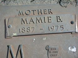

Mary Bell “Mamie” Males Eurom
| Birth | : | 2 Jun 1887 |
| Death | : | Feb 1975 Albion, Marshall County, Iowa, USA |
| Burial | : | St Mary Magdalene Churchyard, Essendine, Rutland Unitary Authority, England |
| Coordinate | : | 52.7026000, -0.4489000 |
| Plot | : | Eurom |
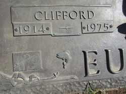
| Description | : | Services for Mrs. John (Mamie) Eurom, 87, rural Albion, were held at Avey Furneral Home at 1:30 p.m. Thursday (2/20), with the Rev L. L. Musser and the Rev L. T. Proctor in charge. Burial was at Rose Hill Memorial Gardens. Mrs. Eurom died at Community Hospital West Tuesday morning, the same day that her son John Clifford Eurom, was buried at Rose Hill Memorial Gardens. Mrs. Eurom was born in Marshallton June 2, 1887, the daughter of Joseph and Ida Schlict Males. She received her education at the Hazel Green School, west of Albion, and lived in the Albion... Read More |
frequently asked questions (FAQ):
-
Where is Mary Bell “Mamie” Males Eurom's memorial?
Mary Bell “Mamie” Males Eurom's memorial is located at: St Mary Magdalene Churchyard, Essendine, Rutland Unitary Authority, England.
-
When did Mary Bell “Mamie” Males Eurom death?
Mary Bell “Mamie” Males Eurom death on Feb 1975 in Albion, Marshall County, Iowa, USA
-
Where are the coordinates of the Mary Bell “Mamie” Males Eurom's memorial?
Latitude: 52.7026000
Longitude: -0.4489000
Family Members:
Parent
Spouse
Siblings
Children

Flowers:


Nearby Cemetories:
1. St Mary Magdalene Churchyard
Essendine, Rutland Unitary Authority, England
Coordinate: 52.7026000, -0.4489000
2. Saint Stephen
Carlby, South Kesteven District, England
Coordinate: 52.7125650, -0.4475800
3. St John the Evangelist Churchyard
Ryhall, Rutland Unitary Authority, England
Coordinate: 52.6852000, -0.4685000
4. Ryhall Churchyard Extension
Ryhall, Rutland Unitary Authority, England
Coordinate: 52.6849000, -0.4678700
5. St. Andrews Churchyard
Witham on the Hill, South Kesteven District, England
Coordinate: 52.7364500, -0.4420300
6. All Saints Churchyard
Little Casterton, Rutland Unitary Authority, England
Coordinate: 52.6775807, -0.4965072
7. St Stephen Churchyard
Careby, South Kesteven District, England
Coordinate: 52.7363500, -0.4823700
8. St Faith Churchyard
Wilsthorpe, South Kesteven District, England
Coordinate: 52.7095208, -0.3848166
9. St Martin Churchyard
Barholm, South Kesteven District, England
Coordinate: 52.6855000, -0.3887600
10. Newstead Priory
Stamford, South Kesteven District, England
Coordinate: 52.6582800, -0.4542480
11. St Michael & All Angels Churchyard
Uffington, South Kesteven District, England
Coordinate: 52.6570400, -0.4321700
12. Greyfriars
Stamford, South Kesteven District, England
Coordinate: 52.6547990, -0.4697460
13. St Wilfrid
Holywell, South Kesteven District, England
Coordinate: 52.7329915, -0.5149881
14. Stamford Cemetery
Stamford, South Kesteven District, England
Coordinate: 52.6564300, -0.4905600
15. St. Michael's Churchyard
Stamford, South Kesteven District, England
Coordinate: 52.6524606, -0.4774019
16. All Saints Church
Stamford, South Kesteven District, England
Coordinate: 52.6522610, -0.4808400
17. St Mary's Churchyard
Stamford, South Kesteven District, England
Coordinate: 52.6514440, -0.4783930
18. St. George's Churchyard
Stamford, South Kesteven District, England
Coordinate: 52.6514110, -0.4782500
19. Saint John the Baptist Church
Stamford, South Kesteven District, England
Coordinate: 52.6517890, -0.4801320
20. St Peter & St Paul Churchyard
Great Casterton, Rutland Unitary Authority, England
Coordinate: 52.6676700, -0.5203600
21. St. Martin's Churchyard
Stamford, South Kesteven District, England
Coordinate: 52.6490200, -0.4773670
22. St. Lawrence's Churchyard
Tallington, South Kesteven District, England
Coordinate: 52.6574520, -0.3879120
23. Baston Cemetery
Baston, South Kesteven District, England
Coordinate: 52.7149917, -0.3531338
24. St John the Baptist Churchyard
Baston, South Kesteven District, England
Coordinate: 52.7149530, -0.3530650