
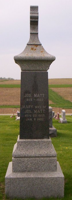

Mary Berns Matt
| Birth | : | 23 Nov 1859 Clayton County, Iowa, USA |
| Death | : | 8 Jan 1892 Clayton County, Iowa, USA |
| Burial | : | Saint Joseph Cemetery, Garnavillo, Clayton County, USA |
| Coordinate | : | 42.8628006, -91.2502975 |
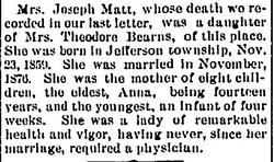
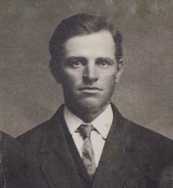
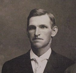
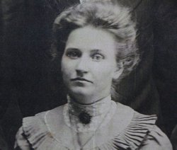
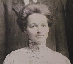
| Description | : | Mary Berns was a daughter of Prussian-born immigrants, Theodore and Mary Berns, and was born on 23 November 1859 in Jefferson Township, Clayton Co., Iowa. In November 1876 she was married at age seventeen to Joseph Matt, also of Clayton Co., Iowa. By the next year Mary had given birth to their daughter, Anna, the first of eight children to be born between 1877 to December 1891. Mary and her husband farmed the south half of the NW quarter in Township 94 Range 4 Section 26 in Clayton Co., Iowa. DEATH: Less than a month after the birth... Read More |
frequently asked questions (FAQ):
-
Where is Mary Berns Matt's memorial?
Mary Berns Matt's memorial is located at: Saint Joseph Cemetery, Garnavillo, Clayton County, USA.
-
When did Mary Berns Matt death?
Mary Berns Matt death on 8 Jan 1892 in Clayton County, Iowa, USA
-
Where are the coordinates of the Mary Berns Matt's memorial?
Latitude: 42.8628006
Longitude: -91.2502975
Family Members:
Parent

Spouse
Siblings
Children

Flowers:


Nearby Cemetories:
1. Saint Joseph Cemetery
Garnavillo, Clayton County, USA
Coordinate: 42.8628006, -91.2502975
2. Garnavillo Community Cemetery
Garnavillo, Clayton County, USA
Coordinate: 42.8656000, -91.2422100
3. Garnavillo Cemetery
Garnavillo, Clayton County, USA
Coordinate: 42.8660300, -91.2390100
4. McClelland Cemetery
Garnavillo, Clayton County, USA
Coordinate: 42.8249879, -91.2084641
5. Clayton Center Cemetery
Clayton Center, Clayton County, USA
Coordinate: 42.8841705, -91.3225021
6. Zion Lutheran Cemetery
Clayton Center, Clayton County, USA
Coordinate: 42.8841705, -91.3249969
7. Pioneer Rock Cemetery
Ceres, Clayton County, USA
Coordinate: 42.8230591, -91.1863937
8. Clayton Cemetery
Clayton, Clayton County, USA
Coordinate: 42.9043999, -91.1641998
9. Saint Michael Cemetery
Clayton County, USA
Coordinate: 42.8055992, -91.1802979
10. County Home Cemetery
Clayton Center, Clayton County, USA
Coordinate: 42.8916702, -91.3499985
11. Tangeman Family Cemetery
Garnavillo, Clayton County, USA
Coordinate: 42.8580000, -91.1420000
12. Krumm Cemetery
Garber, Clayton County, USA
Coordinate: 42.7913760, -91.3023559
13. Colony Catholic Cemetery (Defunct)
Read Township, Clayton County, USA
Coordinate: 42.8830000, -91.3580000
14. Borcherding Cemetery
Jefferson Township, Clayton County, USA
Coordinate: 42.8182983, -91.1414032
15. National Cemetery
National, Clayton County, USA
Coordinate: 42.9536018, -91.2902985
16. Meenan Cemetery
Communia, Clayton County, USA
Coordinate: 42.7999862, -91.3584693
17. Storck Cemetery
Guttenberg, Clayton County, USA
Coordinate: 42.7694335, -91.1834638
18. Saint Paula Cemetery
Osterdock, Clayton County, USA
Coordinate: 42.7635994, -91.1992035
19. Old Garber Cemetery
Garber, Clayton County, USA
Coordinate: 42.7560005, -91.2580032
20. Elkader Cemetery
Elkader, Clayton County, USA
Coordinate: 42.8541718, -91.4000015
21. Hartman Cemetery
Cox Creek Township, Clayton County, USA
Coordinate: 42.8155360, -91.3880840
22. Harford Cemetery
Wyalusing, Grant County, USA
Coordinate: 42.9401000, -91.1401800
23. Saint Josephs Cemetery
Elkader, Clayton County, USA
Coordinate: 42.8488998, -91.4021988
24. Communia Cemetery
Volga Township, Clayton County, USA
Coordinate: 42.7868996, -91.3630981