


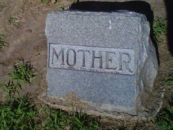
Mary E Redfern Ryan
| Birth | : | 22 Apr 1858 Peoria, Peoria County, Illinois, USA |
| Death | : | 12 Jul 1928 Exeter, Fillmore County, Nebraska, USA |
| Burial | : | Calvary Cemetery, Louisville, Jefferson County, USA |
| Coordinate | : | 38.2256300, -85.7134700 |
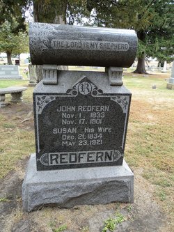
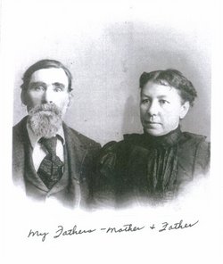
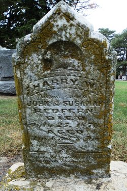
| Description | : | Mary E Redfern was born in Peoria, Richwoods,Illinois in 1858 to Susan and John Redfern.She had six siblings,she was second to oldest.Her family moved to Exeter,Fillmore,Nebraska late 1860's. Her parents Susan Sweeley and John Redfern moved to after the Civil War,with the Ryan brothers Lawrence and Parkerson.Rosa,Mary's aunt was married Parkerson Ryan.Michael Sweeley her uncle,the Drummond family and the Hammonds, were all part of the same pioneering group to claim their land grants given to them for being in the military during the Civil War. They all homesteaded next to each other and helped each other get started. One by... Read More |
frequently asked questions (FAQ):
-
Where is Mary E Redfern Ryan's memorial?
Mary E Redfern Ryan's memorial is located at: Calvary Cemetery, Louisville, Jefferson County, USA.
-
When did Mary E Redfern Ryan death?
Mary E Redfern Ryan death on 12 Jul 1928 in Exeter, Fillmore County, Nebraska, USA
-
Where are the coordinates of the Mary E Redfern Ryan's memorial?
Latitude: 38.2256300
Longitude: -85.7134700
Family Members:
Parent

Spouse
Siblings

Children
Flowers:


Nearby Cemetories:
1. Calvary Cemetery
Louisville, Jefferson County, USA
Coordinate: 38.2256300, -85.7134700
2. Louisville Cemetery
Louisville, Jefferson County, USA
Coordinate: 38.2226905, -85.7276820
3. Prather Cemetery
Louisville, Jefferson County, USA
Coordinate: 38.2096570, -85.7075220
4. Clark Cemetery
Parkway Village, Jefferson County, USA
Coordinate: 38.2139015, -85.7285995
5. Mulberry Hill Cemetery
Louisville, Jefferson County, USA
Coordinate: 38.2139200, -85.7289130
6. Cave Hill Cemetery
Louisville, Jefferson County, USA
Coordinate: 38.2453600, -85.7146400
7. Phillips-Durrett-Clark Cemetery
Louisville, Jefferson County, USA
Coordinate: 38.2052780, -85.7052780
8. Eastern Cemetery
Louisville, Jefferson County, USA
Coordinate: 38.2470500, -85.7249100
9. Cave Hill National Cemetery
Louisville, Jefferson County, USA
Coordinate: 38.2483800, -85.7196000
10. Doup Family Cemetery
Louisville, Jefferson County, USA
Coordinate: 38.2211500, -85.6821200
11. Louisville Presbyterian Seminary Memorial Garden
Louisville, Jefferson County, USA
Coordinate: 38.2387380, -85.6861190
12. Agudath Achim Cemetery
Louisville, Jefferson County, USA
Coordinate: 38.2097080, -85.7392200
13. Adath Jeshurun Cemetery
Louisville, Jefferson County, USA
Coordinate: 38.2075500, -85.7381470
14. Hackberry Cemetery
Louisville, Jefferson County, USA
Coordinate: 38.2514500, -85.7032170
15. Keneseth Israel Cemetery
Louisville, Jefferson County, USA
Coordinate: 38.2070250, -85.7397510
16. Anshei Sfard Cemetery
Louisville, Jefferson County, USA
Coordinate: 38.2070420, -85.7413660
17. Fort George Cemetery
Louisville, Jefferson County, USA
Coordinate: 38.2320530, -85.7522260
18. Louisville Crematorium Custodial Storage
Louisville, Jefferson County, USA
Coordinate: 38.2149200, -85.7583300
19. Oldham Family Cemetery
Louisville, Jefferson County, USA
Coordinate: 38.1985870, -85.7459520
20. Louis D. Brandeis School of Law
Louisville, Jefferson County, USA
Coordinate: 38.2155450, -85.7608910
21. First Unitarian Memorial Garden
Louisville, Jefferson County, USA
Coordinate: 38.2437920, -85.7583330
22. Calvary Episcopal Church Burial Grounds
Louisville, Jefferson County, USA
Coordinate: 38.2437866, -85.7593283
23. Evergreen Cemetery
Louisville, Jefferson County, USA
Coordinate: 38.1828003, -85.7142029
24. Cathedral of the Assumption
Louisville, Jefferson County, USA
Coordinate: 38.2525680, -85.7588370