
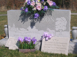
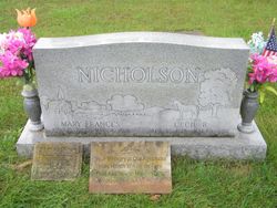

Mary Frances Green Nicholson
| Birth | : | 15 Apr 1929 Campbellsburg, Washington County, Indiana, USA |
| Death | : | 4 Mar 2006 Louisville, Jefferson County, Kentucky, USA |
| Burial | : | St Firmin Churchyard, Thurlby, South Kesteven District, England |
| Coordinate | : | 52.7375960, -0.3646650 |
frequently asked questions (FAQ):
-
Where is Mary Frances Green Nicholson's memorial?
Mary Frances Green Nicholson's memorial is located at: St Firmin Churchyard, Thurlby, South Kesteven District, England.
-
When did Mary Frances Green Nicholson death?
Mary Frances Green Nicholson death on 4 Mar 2006 in Louisville, Jefferson County, Kentucky, USA
-
Where are the coordinates of the Mary Frances Green Nicholson's memorial?
Latitude: 52.7375960
Longitude: -0.3646650
Family Members:
Parent

Spouse

Siblings
Flowers:


Nearby Cemetories:
1. St Firmin Churchyard
Thurlby, South Kesteven District, England
Coordinate: 52.7375960, -0.3646650
2. Bourne Cemetery
Bourne, South Kesteven District, England
Coordinate: 52.7607264, -0.3714663
3. Baston Cemetery
Baston, South Kesteven District, England
Coordinate: 52.7149917, -0.3531338
4. St John the Baptist Churchyard
Baston, South Kesteven District, England
Coordinate: 52.7149530, -0.3530650
5. Bourne Abbey
Bourne, South Kesteven District, England
Coordinate: 52.7661320, -0.3758389
6. St Faith Churchyard
Wilsthorpe, South Kesteven District, England
Coordinate: 52.7095208, -0.3848166
7. St Michael and All Angels Churchyard
Langtoft, South Kesteven District, England
Coordinate: 52.6990300, -0.3389800
8. St. Andrews Churchyard
Witham on the Hill, South Kesteven District, England
Coordinate: 52.7364500, -0.4420300
9. St Martin Churchyard
Barholm, South Kesteven District, England
Coordinate: 52.6855000, -0.3887600
10. Saint Stephen
Carlby, South Kesteven District, England
Coordinate: 52.7125650, -0.4475800
11. St Michael Churchyard
Edenham, South Kesteven District, England
Coordinate: 52.7836110, -0.4266560
12. St Mary Magdalene Churchyard
Essendine, Rutland Unitary Authority, England
Coordinate: 52.7026000, -0.4489000
13. St Medard and St Gildard Churchyard
Little Bytham, South Kesteven District, England
Coordinate: 52.6786110, -0.3200000
14. St John the Baptist Churchyard
Morton, South Kesteven District, England
Coordinate: 52.8025100, -0.3724200
15. St Stephen Churchyard
Careby, South Kesteven District, England
Coordinate: 52.7363500, -0.4823700
16. St. Andrew's Churchyard
West Deeping, South Kesteven District, England
Coordinate: 52.6640285, -0.3614634
17. St Andrew's Churchyard
Haconby, South Kesteven District, England
Coordinate: 52.8135400, -0.3594300
18. St. James Cemetery
Deeping St James, South Kesteven District, England
Coordinate: 52.6716340, -0.2899500
19. St. James Churchyard
Deeping St James, South Kesteven District, England
Coordinate: 52.6716980, -0.2896360
20. St. Peter's Churchyard
Maxey, Peterborough Unitary Authority, England
Coordinate: 52.6575500, -0.3455940
21. St. Lawrence's Churchyard
Tallington, South Kesteven District, England
Coordinate: 52.6574520, -0.3879120
22. Ryhall Churchyard Extension
Ryhall, Rutland Unitary Authority, England
Coordinate: 52.6849000, -0.4678700
23. St John the Evangelist Churchyard
Ryhall, Rutland Unitary Authority, England
Coordinate: 52.6852000, -0.4685000
24. St Peter Churchyard
Creeton, South Kesteven District, England
Coordinate: 52.7669500, -0.4977300