
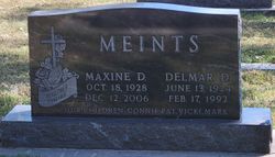

Maxine D. De Ryke Meints
| Birth | : | 18 Oct 1928 Cortland, Gage County, Nebraska, USA |
| Death | : | 12 Dec 2006 Wymore, Gage County, Nebraska, USA |
| Burial | : | St. Wulfram Churchyard, Grantham, South Kesteven District, England |
| Coordinate | : | 52.9148180, -0.6408520 |
| Plot | : | 37 |
| Description | : | Maxine D. Meints, 78, of Beatrice died at the Wymore Good Samaritan Center on Tuesday morning, December 12, 2006. She was born on October 18, 1928 at rural Cortland, Nebraska. After her graduation from Beatrice High School in 1946, she taught school at a rural Pickrell school. She married Delmar Meints on May 29, 1947 at Marysville, Kansas. She worked at various places including Swifts, Campbell's Soup Company and Montgomery Wards. She owned and operated D & M Café in Cortland for several years and enjoyed ironing for people. She was a member of St. John Lutheran Church and American... Read More |
frequently asked questions (FAQ):
-
Where is Maxine D. De Ryke Meints's memorial?
Maxine D. De Ryke Meints's memorial is located at: St. Wulfram Churchyard, Grantham, South Kesteven District, England.
-
When did Maxine D. De Ryke Meints death?
Maxine D. De Ryke Meints death on 12 Dec 2006 in Wymore, Gage County, Nebraska, USA
-
Where are the coordinates of the Maxine D. De Ryke Meints's memorial?
Latitude: 52.9148180
Longitude: -0.6408520
Family Members:
Parent

Spouse
Siblings

Flowers:


Nearby Cemetories:
1. St. Wulfram Churchyard
Grantham, South Kesteven District, England
Coordinate: 52.9148180, -0.6408520
2. Manthorpe Road Old Cemetery
Grantham, South Kesteven District, England
Coordinate: 52.9173900, -0.6409900
3. Grantham Cemetery and Crematorium
Grantham, South Kesteven District, England
Coordinate: 52.9095320, -0.6326120
4. St John the Evangelist Churchyard
Manthorpe, South Kesteven District, England
Coordinate: 52.9306320, -0.6323160
5. St Sebastian Churchyard
Great Gonerby, South Kesteven District, England
Coordinate: 52.9329260, -0.6657700
6. All Saints Churchyard
Barrowby, South Kesteven District, England
Coordinate: 52.9186420, -0.6946810
7. St. Peter and St. Paul's Churchyard
Belton, South Kesteven District, England
Coordinate: 52.9451000, -0.6177000
8. St. Guthlac Churchyard
Little Ponton, South Kesteven District, England
Coordinate: 52.8796100, -0.6271200
9. St John the Baptist Churchyard
Londonthorpe, South Kesteven District, England
Coordinate: 52.9312060, -0.5837350
10. St Mary and St Peter Churchyard
Harlaxton, South Kesteven District, England
Coordinate: 52.8836860, -0.6895640
11. St Marys Churchyard
Syston, South Kesteven District, England
Coordinate: 52.9578420, -0.6172940
12. All Saints Churchyard
Stroxton, South Kesteven District, England
Coordinate: 52.8695300, -0.6609700
13. St. Mary Magdalene Churchyard
Old Somerby, South Kesteven District, England
Coordinate: 52.8944900, -0.5672830
14. St Nicholas Churchyard
Barkston, South Kesteven District, England
Coordinate: 52.9629960, -0.6129380
15. Holy Cross Churchyard
Great Ponton, South Kesteven District, England
Coordinate: 52.8638270, -0.6275570
16. St. Lawrence Churchyard
Sedgebrook, South Kesteven District, England
Coordinate: 52.9329460, -0.7256530
17. St Andrew Churchyard
Denton, South Kesteven District, England
Coordinate: 52.8828830, -0.7151840
18. St James Churchyard
Allington, South Kesteven District, England
Coordinate: 52.9525695, -0.7245301
19. Saint Andrew Churchyard
Boothby Pagnell, South Kesteven District, England
Coordinate: 52.8660600, -0.5578600
20. St. Wilfrid Churchyard
Honington, South Kesteven District, England
Coordinate: 52.9795600, -0.5965700
21. St. Peter's Churchyard
Ropsley, South Kesteven District, England
Coordinate: 52.8959736, -0.5259958
22. Ropsley Churchyard Extension
Ropsley, South Kesteven District, England
Coordinate: 52.8958475, -0.5254147
23. St James Churchyard
Woolsthorpe-by-Belvoir, South Kesteven District, England
Coordinate: 52.8957880, -0.7578370
24. All Saints Churchyard
Hougham, South Kesteven District, England
Coordinate: 52.9878240, -0.6806910