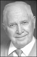
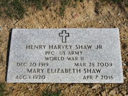
PFC Henry Harvey Shaw Jr.
| Birth | : | 20 Dec 1919 Allegany County, Maryland, USA |
| Death | : | 28 Mar 2009 Cumberland, Allegany County, Maryland, USA |
| Burial | : | Bergholz Cemetery, Bergholz, Jefferson County, USA |
| Coordinate | : | 40.5155983, -80.8955994 |
| Plot | : | SECTION H-3 ROW 6 SITE 16 |
| Description | : | CUMBERLAND,MARYLAND — Henry Harvey Shaw Jr., 89, of Cumberland, died on Saturday, March 28, 2009, at The Lions Center for Rehabilitation and Extended Care. Born Dec. 20, 1919, in Allegany County, he was the son of the late Henry Harvey Shaw Sr. and Eleanor (Robertson) Shaw. He was the last surviving member of his immediate family. A United States Army veteran of World War II, Mr. Shaw was retired from Celanese Fibers Corporation of America. Mr. Shaw is survived by his wife of 69 years, Mary E. (Twigg) Shaw; two sons, Eugene H. Shaw, of Martinsburg, W.Va., and Delmis H. Shaw and wife... Read More |
frequently asked questions (FAQ):
-
Where is PFC Henry Harvey Shaw Jr.'s memorial?
PFC Henry Harvey Shaw Jr.'s memorial is located at: Bergholz Cemetery, Bergholz, Jefferson County, USA.
-
When did PFC Henry Harvey Shaw Jr. death?
PFC Henry Harvey Shaw Jr. death on 28 Mar 2009 in Cumberland, Allegany County, Maryland, USA
-
Where are the coordinates of the PFC Henry Harvey Shaw Jr.'s memorial?
Latitude: 40.5155983
Longitude: -80.8955994
Family Members:
Spouse
Flowers:

Henry was a United States Army veteran of World War II
Left by Anonymous on 27 Dec 2009

PFC US ARMY======WORLD WAR II
Left by Anonymous on 15 Apr 2010
Left by Anonymous on 15 Apr 2010

Henry was a United States Army veteran of World War II
Left by Anonymous on 27 Dec 2009

PFC US ARMY======WORLD WAR II
Left by Anonymous on 15 Apr 2010
Left by Anonymous on 15 Apr 2010
Nearby Cemetories:
1. Bergholz Cemetery
Bergholz, Jefferson County, USA
Coordinate: 40.5155983, -80.8955994
2. Dorn Cemetery
Bergholz, Jefferson County, USA
Coordinate: 40.5257988, -80.8625031
3. Amsterdam Catholic Cemetery
Amsterdam, Jefferson County, USA
Coordinate: 40.4899390, -80.9093740
4. Circle Green Cemetery
Springfield Township, Jefferson County, USA
Coordinate: 40.4817610, -80.8769050
5. Yellow Creek Cemetery
Bergholz, Jefferson County, USA
Coordinate: 40.5193740, -80.8438470
6. Mooretown Methodist Episcopal Cemetery
Ross Township, Jefferson County, USA
Coordinate: 40.5189200, -80.8391800
7. Wells-Jackman Cemetery
Carroll County, USA
Coordinate: 40.5177994, -80.9522018
8. Chestnut Ridge Cemetery
Harlem Springs, Carroll County, USA
Coordinate: 40.5491982, -80.9336014
9. Saint Joseph Cemetery
Amsterdam, Jefferson County, USA
Coordinate: 40.4756230, -80.9229770
10. Amsterdam Cemetery
Loudon Township, Carroll County, USA
Coordinate: 40.4752998, -80.9250031
11. Brush Creek Baptist Cemetery
Carroll County, USA
Coordinate: 40.5624008, -80.8715973
12. Kisha Farm Cemetery
Wolf Run, Jefferson County, USA
Coordinate: 40.4646988, -80.8964005
13. Crawford Cemetery
Lee Township, Carroll County, USA
Coordinate: 40.4935030, -80.9578650
14. All Saints Russian Orthodox Church Cemetery
Wolf Run, Jefferson County, USA
Coordinate: 40.4598130, -80.8920900
15. Greenbrier-West Union Cemetery
Carroll County, USA
Coordinate: 40.5696983, -80.8728027
16. Montgomery Cemetery
East Springfield, Jefferson County, USA
Coordinate: 40.4776540, -80.8347600
17. Simmons Ridge Cemetery
Carroll County, USA
Coordinate: 40.4757996, -80.9621964
18. Miller Cemetery
Springfield Township, Jefferson County, USA
Coordinate: 40.4509580, -80.8913850
19. McGauran Cemetery
Harlem Springs, Carroll County, USA
Coordinate: 40.5522003, -80.9749985
20. Shane Cemetery
Shane, Jefferson County, USA
Coordinate: 40.4808006, -80.8127975
21. East Springfield Cemetery
East Springfield, Jefferson County, USA
Coordinate: 40.4490890, -80.8592080
22. Davidson Cemetery
Springfield Township, Jefferson County, USA
Coordinate: 40.4441986, -80.8818970
23. Seever Cemetery
Ross Township, Jefferson County, USA
Coordinate: 40.5233561, -80.7984235
24. Palmer Cemetery
Fox Township, Carroll County, USA
Coordinate: 40.5578003, -80.9764023


