
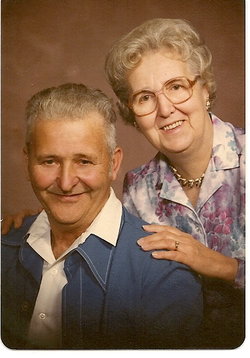
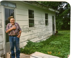


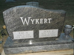
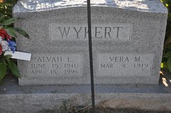
Ray Nelson Wykert
| Birth | : | 3 Jan 1916 Oakville, Louisa County, Iowa, USA |
| Death | : | 28 Feb 2006 West Burlington, Des Moines County, Iowa, USA |
| Burial | : | St Firmin Churchyard, Thurlby, South Kesteven District, England |
| Coordinate | : | 52.7375960, -0.3646650 |
| Description | : | Burlington Hawk Eye, March 2, 2006 Ray Nelson Wykert, 90, of Morning Sun Care Center, formerly of rural Oakville, died Tuesday afternoon, Feb. 28, 2006, at Great River Medical Center in West Burlington. Born Jan. 3, 1916, in rural Oakville, he was the son of George and Mary Whitaker Wykert. On June 15, 1940, he married Jean E. Sands in Waterloo. Mr. Wykert was a farmer and a commercial fisherman. He attended school at Huron High School. He was a member of Farm Bureau. He enjoyed farming, fishing and trapping. Survivors include his wife; two sons, Harry Wykert of Morning... Read More |
frequently asked questions (FAQ):
-
Where is Ray Nelson Wykert's memorial?
Ray Nelson Wykert's memorial is located at: St Firmin Churchyard, Thurlby, South Kesteven District, England.
-
When did Ray Nelson Wykert death?
Ray Nelson Wykert death on 28 Feb 2006 in West Burlington, Des Moines County, Iowa, USA
-
Where are the coordinates of the Ray Nelson Wykert's memorial?
Latitude: 52.7375960
Longitude: -0.3646650
Family Members:
Parent
Spouse
Siblings

Children
Flowers:


Nearby Cemetories:
1. St Firmin Churchyard
Thurlby, South Kesteven District, England
Coordinate: 52.7375960, -0.3646650
2. Bourne Cemetery
Bourne, South Kesteven District, England
Coordinate: 52.7607264, -0.3714663
3. Baston Cemetery
Baston, South Kesteven District, England
Coordinate: 52.7149917, -0.3531338
4. St John the Baptist Churchyard
Baston, South Kesteven District, England
Coordinate: 52.7149530, -0.3530650
5. Bourne Abbey
Bourne, South Kesteven District, England
Coordinate: 52.7661320, -0.3758389
6. St Faith Churchyard
Wilsthorpe, South Kesteven District, England
Coordinate: 52.7095208, -0.3848166
7. St Michael and All Angels Churchyard
Langtoft, South Kesteven District, England
Coordinate: 52.6990300, -0.3389800
8. St. Andrews Churchyard
Witham on the Hill, South Kesteven District, England
Coordinate: 52.7364500, -0.4420300
9. St Martin Churchyard
Barholm, South Kesteven District, England
Coordinate: 52.6855000, -0.3887600
10. Saint Stephen
Carlby, South Kesteven District, England
Coordinate: 52.7125650, -0.4475800
11. St Michael Churchyard
Edenham, South Kesteven District, England
Coordinate: 52.7836110, -0.4266560
12. St Mary Magdalene Churchyard
Essendine, Rutland Unitary Authority, England
Coordinate: 52.7026000, -0.4489000
13. St Medard and St Gildard Churchyard
Little Bytham, South Kesteven District, England
Coordinate: 52.6786110, -0.3200000
14. St John the Baptist Churchyard
Morton, South Kesteven District, England
Coordinate: 52.8025100, -0.3724200
15. St Stephen Churchyard
Careby, South Kesteven District, England
Coordinate: 52.7363500, -0.4823700
16. St. Andrew's Churchyard
West Deeping, South Kesteven District, England
Coordinate: 52.6640285, -0.3614634
17. St Andrew's Churchyard
Haconby, South Kesteven District, England
Coordinate: 52.8135400, -0.3594300
18. St. James Cemetery
Deeping St James, South Kesteven District, England
Coordinate: 52.6716340, -0.2899500
19. St. James Churchyard
Deeping St James, South Kesteven District, England
Coordinate: 52.6716980, -0.2896360
20. St. Peter's Churchyard
Maxey, Peterborough Unitary Authority, England
Coordinate: 52.6575500, -0.3455940
21. St. Lawrence's Churchyard
Tallington, South Kesteven District, England
Coordinate: 52.6574520, -0.3879120
22. Ryhall Churchyard Extension
Ryhall, Rutland Unitary Authority, England
Coordinate: 52.6849000, -0.4678700
23. St John the Evangelist Churchyard
Ryhall, Rutland Unitary Authority, England
Coordinate: 52.6852000, -0.4685000
24. St Peter Churchyard
Creeton, South Kesteven District, England
Coordinate: 52.7669500, -0.4977300