
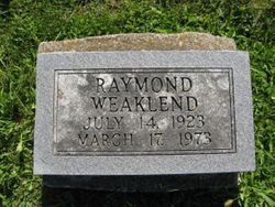
Raymond Lennie Weaklend
| Birth | : | 14 Jul 1923 Clarke County, Iowa, USA |
| Death | : | 17 Mar 1973 Chariton, Lucas County, Iowa, USA |
| Burial | : | Runion Cemetery, Fall Rock, Clay County, USA |
| Coordinate | : | 37.2323100, -83.7872700 |
| Plot | : | Row 13, Headstone 19 |
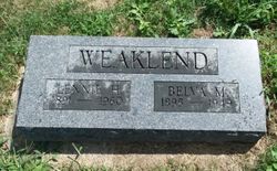
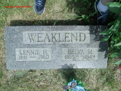
| Description | : | Osceola Tribune, Osceola, Iowa March 20, 1973, Page 10 Ray Weaklend Dies at Chariton Funeral services were held Monday, March 19 for Raymond Lennie Weaklend, 49, who died at the Lucas County Memorial Hospital at Chariton Saturday, March 17. Rev. George V. Neal officiated the 1:30 p.m. service from the Webster-Kale Funeral Home. Raymond Lennie Weaklend was born in Clarke County, Iowa July 14, 1923, the son of Lennie Hugh and Belva Mae McKinney Weaklend. He attended the Clarke County Schools and on December 28, 1956 was married to Wilma Layton. Three children were born to this... Read More |
frequently asked questions (FAQ):
-
Where is Raymond Lennie Weaklend's memorial?
Raymond Lennie Weaklend's memorial is located at: Runion Cemetery, Fall Rock, Clay County, USA.
-
When did Raymond Lennie Weaklend death?
Raymond Lennie Weaklend death on 17 Mar 1973 in Chariton, Lucas County, Iowa, USA
-
Where are the coordinates of the Raymond Lennie Weaklend's memorial?
Latitude: 37.2323100
Longitude: -83.7872700
Family Members:
Parent
Spouse
Siblings

Children
Flowers:


Nearby Cemetories:
1. Runion Cemetery
Fall Rock, Clay County, USA
Coordinate: 37.2323100, -83.7872700
2. Cope Cemetery
Fall Rock, Clay County, USA
Coordinate: 37.2321000, -83.7874500
3. T & B Cemetery
Laurel Creek, Clay County, USA
Coordinate: 37.2294920, -83.7782220
4. Massey Cemetery
Fall Rock, Clay County, USA
Coordinate: 37.2240050, -83.7871950
5. Scott Cemetery
Burning Springs, Clay County, USA
Coordinate: 37.2424500, -83.7902800
6. Elijah Campbell Cemetery
Fall Rock, Clay County, USA
Coordinate: 37.2184200, -83.7898400
7. Spurlock-Gabbard Cemetery
Fall Rock, Clay County, USA
Coordinate: 37.2283790, -83.8050060
8. Chicken Branch Cemetery
Mill Pond, Clay County, USA
Coordinate: 37.2220660, -83.7666400
9. Hensley Cemetery
Laurel Creek, Clay County, USA
Coordinate: 37.2381800, -83.7609800
10. Sizemore Cemetery
Fall Rock, Clay County, USA
Coordinate: 37.2217130, -83.8113370
11. Mize Branch Community Cemetery
Manchester, Clay County, USA
Coordinate: 37.2347259, -83.8159595
12. Bishop Falls Cemetery
Fall Rock, Clay County, USA
Coordinate: 37.2127800, -83.8049030
13. Thompson Cemetery
Burning Springs, Clay County, USA
Coordinate: 37.2430000, -83.8148500
14. James Keith Cemetery
Fall Rock, Clay County, USA
Coordinate: 37.2097480, -83.7730560
15. Massey Family Cemetery
Bernice, Clay County, USA
Coordinate: 37.2132300, -83.7641700
16. Lunsford and Morgan Cemetery
Laurel Creek, Clay County, USA
Coordinate: 37.2346300, -83.7530600
17. Brown Mission Cemetery
Laurel Creek, Clay County, USA
Coordinate: 37.2349800, -83.7527600
18. Coldiron Cemetery
Laurel Creek, Clay County, USA
Coordinate: 37.2351630, -83.7515670
19. Woods Cemetery
Burning Springs, Clay County, USA
Coordinate: 37.2621700, -83.7846000
20. Charlie Hornsby Cemetery
Fall Rock, Clay County, USA
Coordinate: 37.2016400, -83.7850700
21. Collins Cemetery #3
Laurel Creek, Clay County, USA
Coordinate: 37.2472000, -83.7513600
22. Mcqueen Family Cemetery
Burning Springs, Clay County, USA
Coordinate: 37.2607180, -83.8157650
23. George McQueen Cemetery
Clay County, USA
Coordinate: 37.2618100, -83.8162100
24. Old Harris Cemetery
Sidell, Clay County, USA
Coordinate: 37.2226100, -83.8327800