
| Birth | : | 13 May 1833 Greene County, Indiana, USA |
| Death | : | 11 Nov 1912 Loveland, Pottawattamie County, Iowa, USA |
| Burial | : | Branson Cemetery, Loveland, Pottawattamie County, USA |
| Coordinate | : | 41.4846992, -95.8606033 |
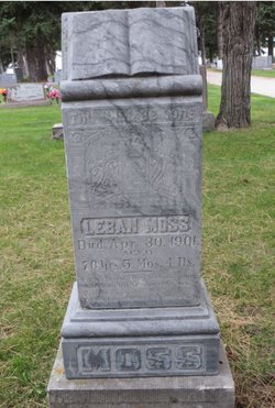
| Description | : | Rev. Joseph Moss. Rev. Joseph Moss, for over half a century a well known man in the western portion of this county, died at 7:30 o’clock Monday morning at the home of his daughter, Mrs. W. E. Hoyt, 2646 Avenue B, after an illness of some duration from kidney trouble. He was 79 years of age, and had been a resident of this county since 1854. Mr. Moss during his prime served in a number of offices, being justice of the peace of Rockford township for many years. He was a farmer in that vicinity, with intervals in which he engaged in... Read More |
frequently asked questions (FAQ):
-
Where is Rev Joseph Earl “Moses” Moss Sr.'s memorial?
Rev Joseph Earl “Moses” Moss Sr.'s memorial is located at: Branson Cemetery, Loveland, Pottawattamie County, USA.
-
When did Rev Joseph Earl “Moses” Moss Sr. death?
Rev Joseph Earl “Moses” Moss Sr. death on 11 Nov 1912 in Loveland, Pottawattamie County, Iowa, USA
-
Where are the coordinates of the Rev Joseph Earl “Moses” Moss Sr.'s memorial?
Latitude: 41.4846992
Longitude: -95.8606033
Family Members:
Parent
Spouse

Siblings
Children
Flowers:


Nearby Cemetories:
1. Branson Cemetery
Loveland, Pottawattamie County, USA
Coordinate: 41.4846992, -95.8606033
2. Crook Cemetery
Honey Creek, Pottawattamie County, USA
Coordinate: 41.4581330, -95.8737000
3. Saint Bridgets Cemetery
Honey Creek, Pottawattamie County, USA
Coordinate: 41.4664001, -95.8289032
4. Oak Grove Cemetery
Missouri Valley, Harrison County, USA
Coordinate: 41.5167007, -95.8649979
5. Allen Cemetery
Pottawattamie County, USA
Coordinate: 41.4427986, -95.8550034
6. Grange Cemetery
Honey Creek, Pottawattamie County, USA
Coordinate: 41.4446678, -95.8034668
7. Reels Cemetery
Crescent, Pottawattamie County, USA
Coordinate: 41.4234100, -95.8321700
8. William C McIntosh Cemetery
Crescent, Pottawattamie County, USA
Coordinate: 41.4088745, -95.8477097
9. Rose Hill Memorial Gardens
Missouri Valley, Harrison County, USA
Coordinate: 41.5656000, -95.8897000
10. Hurleys Evergreen Cemetery
Harrison County, USA
Coordinate: 41.5700989, -95.8618698
11. Mount Carmel Cemetery
Missouri Valley, Harrison County, USA
Coordinate: 41.5675011, -95.8897018
12. Saint Pauls Lutheran Cemetery
Neola, Pottawattamie County, USA
Coordinate: 41.4337000, -95.7607000
13. Champan Frazier Cemetery
Harrison County, USA
Coordinate: 41.5773500, -95.8933500
14. Frazier Cemetery
Missouri Valley, Harrison County, USA
Coordinate: 41.5932999, -95.8375015
15. Linnwood Cemetery
Harrison County, USA
Coordinate: 41.5589200, -95.7502100
16. Crescent Cemetery
Crescent, Pottawattamie County, USA
Coordinate: 41.3664894, -95.8566208
17. Shipley Cemetery
Washington County, USA
Coordinate: 41.3932991, -95.9828033
18. Fort Calhoun Cemetery
Fort Calhoun, Washington County, USA
Coordinate: 41.4581375, -96.0352020
19. Harris Grove Cemetery
Beebeetown, Harrison County, USA
Coordinate: 41.5782928, -95.7262192
20. Hazel Dell Cemetery
Council Bluffs, Pottawattamie County, USA
Coordinate: 41.3489723, -95.7939911
21. Castor Cemetery
Underwood, Pottawattamie County, USA
Coordinate: 41.4127040, -95.6887490
22. Calhoun Cemetery
Calhoun, Harrison County, USA
Coordinate: 41.6391983, -95.8938980
23. Gregg Cemetery
Weston, Pottawattamie County, USA
Coordinate: 41.3330000, -95.7931000
24. Evans Cemetery
Crescent, Pottawattamie County, USA
Coordinate: 41.3255997, -95.8368988