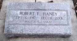
Robert E. Haney
| Birth | : | 6 Sep 1917 Columbus, Platte County, Nebraska, USA |
| Death | : | 11 Dec 2001 Kansas City, Jackson County, Missouri, USA |
| Burial | : | Hartshorn Cemetery, Allen County, USA |
| Coordinate | : | 40.8424988, -84.2908020 |
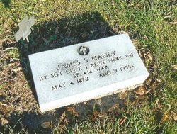
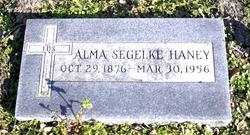
| Description | : | Son of James S. & Alma (Segelke) Haney. He graduated in 1935 from Columbus High School and attended college in Los Angeles, California. In 1945, Robert started working for TWA as a machinist in Los Angeles, later working in San Francisco and Kansas City. After 6 years as a business agent for the International Association of Machinists, Robert was hired into management in 1955, and was for many years Director of Government Industry Liaison, retiring in 1983. He served in the US Army Air Force during WWII from January 6, 1942 to December 3, 1945. He obtained the rank of Master... Read More |
frequently asked questions (FAQ):
-
Where is Robert E. Haney's memorial?
Robert E. Haney's memorial is located at: Hartshorn Cemetery, Allen County, USA.
-
When did Robert E. Haney death?
Robert E. Haney death on 11 Dec 2001 in Kansas City, Jackson County, Missouri, USA
-
Where are the coordinates of the Robert E. Haney's memorial?
Latitude: 40.8424988
Longitude: -84.2908020
Family Members:
Parent
Siblings
Flowers:
Nearby Cemetories:
1. Hartshorn Cemetery
Allen County, USA
Coordinate: 40.8424988, -84.2908020
2. New Saint John's Catholic Cemetery
Delphos, Allen County, USA
Coordinate: 40.8451390, -84.2889380
3. Walnut Grove Cemetery
Delphos, Allen County, USA
Coordinate: 40.8300018, -84.2906036
4. Saint John's Catholic Cemetery
Delphos, Allen County, USA
Coordinate: 40.8423620, -84.3319580
5. King Cemetery
Marion Township, Allen County, USA
Coordinate: 40.8060989, -84.2869034
6. Westside Cemetery
Delphos, Van Wert County, USA
Coordinate: 40.8452988, -84.3507996
7. Pike Cemetery
Elida, Allen County, USA
Coordinate: 40.7947006, -84.2585983
8. Mount Calvary Cemetery
Fort Jennings, Putnam County, USA
Coordinate: 40.8986015, -84.3035965
9. Raabe Cemetery
Fort Jennings, Putnam County, USA
Coordinate: 40.8993988, -84.2789001
10. Carmen Cemetery
Gomer, Allen County, USA
Coordinate: 40.8531380, -84.2118660
11. Saint Joseph Cemetery
Fort Jennings, Putnam County, USA
Coordinate: 40.9056015, -84.2928009
12. Hadding Cemetery
Gomer, Allen County, USA
Coordinate: 40.8319016, -84.2035980
13. Doner Cemetery
Elida, Allen County, USA
Coordinate: 40.7951330, -84.2277470
14. Keirns Cemetery
Sugar Creek Township, Putnam County, USA
Coordinate: 40.8875008, -84.2181015
15. Sharon Mennonite Cemetery
Elida, Allen County, USA
Coordinate: 40.7828080, -84.2332721
16. Salem Mennonite Cemetery
Elida, Allen County, USA
Coordinate: 40.8171220, -84.1851000
17. Saint John the Baptist Catholic Cemetery
Landeck, Allen County, USA
Coordinate: 40.7999992, -84.3874969
18. Lutheran Cemetery
Elida, Allen County, USA
Coordinate: 40.7877998, -84.2050018
19. Ottawa River Cemetery
Rimer, Putnam County, USA
Coordinate: 40.9061012, -84.2080994
20. Saint Marys Cemetery
Ottoville, Putnam County, USA
Coordinate: 40.9261017, -84.3399963
21. Pike Run Cemetery
Gomer, Allen County, USA
Coordinate: 40.8432999, -84.1669006
22. Greenlawn Cemetery
Elida, Allen County, USA
Coordinate: 40.7691994, -84.2024994
23. Hammons Cemetery
Ottoville, Putnam County, USA
Coordinate: 40.9223370, -84.3701410
24. West Union Cemetery
Spencerville, Allen County, USA
Coordinate: 40.7574997, -84.3641968

