
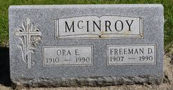
| Birth | : | 3 Mar 1925 Hayti, Hamlin County, South Dakota, USA |
| Death | : | 1 Feb 1999 Grand Island, Hall County, Nebraska, USA |
| Burial | : | Redan Road Cemetery, Aldershot, Rushmoor Borough, England |
| Coordinate | : | 51.2495610, -0.7488900 |
| Description | : | Thanks to contributor #48796369 Ross E. Waite, 73, of Wood River died Monday, Feb. 1, 1999, at St. Francis Medical Center. Services will be at 10:30 a.m. Friday at Apfel Funeral Home in Wood River. The Rev. Larry Nothstine will officiate. Burial with military rites will be in the Wood River Cemetery. Visitation will be from 5 to 8 p.m. Thursday at the funeral home. Mr. Waite was born on March 3, 1925, at Hayti, S.D., to Clyde and Clara (Jensen) Waite. He was educated at Hayti and graduated in 1943. He entered the Navy and... Read More |
frequently asked questions (FAQ):
-
Where is Ross Erwin Waite's memorial?
Ross Erwin Waite's memorial is located at: Redan Road Cemetery, Aldershot, Rushmoor Borough, England.
-
When did Ross Erwin Waite death?
Ross Erwin Waite death on 1 Feb 1999 in Grand Island, Hall County, Nebraska, USA
-
Where are the coordinates of the Ross Erwin Waite's memorial?
Latitude: 51.2495610
Longitude: -0.7488900
Family Members:
Parent
Spouse

Siblings
Children
Flowers:


Nearby Cemetories:
1. Aldershot Jewish Cemetery
Aldershot, Rushmoor Borough, England
Coordinate: 51.2508900, -0.7463000
2. Aldershot Military Cemetery
Aldershot, Rushmoor Borough, England
Coordinate: 51.2554779, -0.7449350
3. St Michael the Archangel Churchyard
Aldershot, Rushmoor Borough, England
Coordinate: 51.2414300, -0.7558900
4. Aldershot Crematorium
Aldershot, Rushmoor Borough, England
Coordinate: 51.2325970, -0.7443200
5. Emery Gates Cemetery
Ash, Guildford Borough, England
Coordinate: 51.2500370, -0.7163210
6. St Peter Churchyard
Ash, Guildford Borough, England
Coordinate: 51.2490760, -0.7155380
7. Ash War Memorial
Ash, Guildford Borough, England
Coordinate: 51.2546746, -0.7157783
8. Saint John the Evangelist Churchyard
Hale, Waverley Borough, England
Coordinate: 51.2280880, -0.7849360
9. St Lawrence Churchyard
Seale, Guildford Borough, England
Coordinate: 51.2231840, -0.7170140
10. Upper Hale Cemetery
Farnham, Waverley Borough, England
Coordinate: 51.2352700, -0.8001800
11. St. Mark's Churchyard
Pirbright, Guildford Borough, England
Coordinate: 51.2549050, -0.6812810
12. St. Peter's Churchyard
Farnborough, Rushmoor Borough, England
Coordinate: 51.2924100, -0.7499300
13. Victoria Road Cemetery
Farnborough, Rushmoor Borough, England
Coordinate: 51.2941300, -0.7593900
14. St Michael's Abbey
Farnborough, Rushmoor Borough, England
Coordinate: 51.2971140, -0.7497110
15. St Andrew Churchyard
Farnham, Waverley Borough, England
Coordinate: 51.2131350, -0.8007400
16. St. John the Baptist Churchyard
Farnborough, Rushmoor Borough, England
Coordinate: 51.2973050, -0.7819310
17. St Mary Churchyard
Ewshot, Hart District, England
Coordinate: 51.2416700, -0.8322800
18. West Street Cemetery
Farnham, Waverley Borough, England
Coordinate: 51.2109000, -0.8093900
19. Ship Lane Cemetery
Farnborough, Rushmoor Borough, England
Coordinate: 51.3057800, -0.7488900
20. St. Bartholomew's Churchyard
Wanborough, Guildford Borough, England
Coordinate: 51.2317700, -0.6625100
21. St. John the Baptist Churchyard
Puttenham, Guildford Borough, England
Coordinate: 51.2222610, -0.6650440
22. Christ Church Churchyard
Crookham Village, Hart District, England
Coordinate: 51.2597200, -0.8438180
23. Deepcut Military Cemetery
Deepcut, Surrey Heath Borough, England
Coordinate: 51.3062170, -0.7049060
24. Puttenham Cemetery
Puttenham, Guildford Borough, England
Coordinate: 51.2204130, -0.6590980