
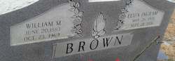
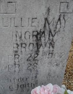
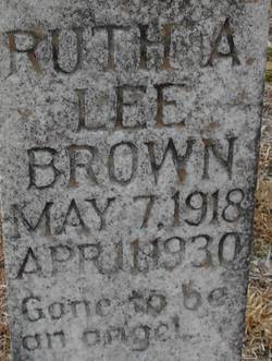
| Birth | : | 28 Apr 1927 Cheraw, Chesterfield County, South Carolina, USA |
| Death | : | 21 Jul 1996 |
| Burial | : | Faith Freewill Baptist Church Cemetery, Cheraw, Chesterfield County, USA |
| Coordinate | : | 34.6717450, -79.9451980 |
| Description | : | I do not know what the L stands for. If you know let me know. |
frequently asked questions (FAQ):
-
Where is Ruby Margaret Brown Boone's memorial?
Ruby Margaret Brown Boone's memorial is located at: Faith Freewill Baptist Church Cemetery, Cheraw, Chesterfield County, USA.
-
When did Ruby Margaret Brown Boone death?
Ruby Margaret Brown Boone death on 21 Jul 1996 in
-
Where are the coordinates of the Ruby Margaret Brown Boone's memorial?
Latitude: 34.6717450
Longitude: -79.9451980
Family Members:
Parent
Spouse

Siblings
Children
Flowers:


Nearby Cemetories:
1. J. C. Broome Memorial Garden
Cheraw, Chesterfield County, USA
Coordinate: 34.6753830, -79.9346970
2. Fisher Hill Community Cemetery
Cheraw, Chesterfield County, USA
Coordinate: 34.6738360, -79.9319040
3. Progressive Church of Our Lord Jesus Christ Cemete
Cheraw, Chesterfield County, USA
Coordinate: 34.6910300, -79.9387430
4. Pleasant Grove United Methodist Church Cemetery
Cheraw, Chesterfield County, USA
Coordinate: 34.7048630, -79.9539520
5. Chatham Hill Memorial Gardens
Cheraw, Chesterfield County, USA
Coordinate: 34.6719017, -79.9019012
6. Prince Of Peace Church Cemetery
Cheraw, Chesterfield County, USA
Coordinate: 34.7076230, -79.9484660
7. Smithville Cemetery
Chesterfield County, USA
Coordinate: 34.7047005, -79.9669037
8. Pleasant Hill Baptist Church Cemetery
Cheraw, Chesterfield County, USA
Coordinate: 34.6372990, -79.9684310
9. Forest Pine Freewill Independent Church Cemetery
Cheraw, Chesterfield County, USA
Coordinate: 34.6324050, -79.9585820
10. First Southern Methodist Church Cemetery
Cheraw, Chesterfield County, USA
Coordinate: 34.6692090, -79.9958000
11. Mount Olivet United Methodist Church Cemetery
Hunts Mill, Chesterfield County, USA
Coordinate: 34.6623192, -79.9972763
12. Foundry Hill Cemetery
Cheraw, Chesterfield County, USA
Coordinate: 34.6957350, -79.8998800
13. Saint Paul Missionary Baptist Church
Cheraw, Chesterfield County, USA
Coordinate: 34.7109260, -79.9745410
14. Saint Josephs Cemetery
Cheraw, Chesterfield County, USA
Coordinate: 34.7175410, -79.9702010
15. Lower Macedonia Memorial Garden
Chesterfield, Chesterfield County, USA
Coordinate: 34.6688470, -80.0077090
16. Midway Baptist Church Cemetery
Cheraw, Chesterfield County, USA
Coordinate: 34.7170570, -79.9826580
17. Curry Family Cemetery
Chesterfield, Chesterfield County, USA
Coordinate: 34.6478430, -80.0053170
18. Old Saint Davids Episcopal Church Cemetery
Cheraw, Chesterfield County, USA
Coordinate: 34.6956140, -79.8794250
19. Erasmus Powe Family Cemetery
Cheraw, Chesterfield County, USA
Coordinate: 34.7041400, -79.8822950
20. Pee Dee Union Baptist Church Cemetery
Cheraw, Chesterfield County, USA
Coordinate: 34.6968440, -79.8775160
21. Piney Grove Baptist Church Cemetery
Patrick, Chesterfield County, USA
Coordinate: 34.6144500, -79.9728500
22. Robinson Zion Church
Cheraw, Chesterfield County, USA
Coordinate: 34.7328090, -79.9323420
23. Goodman Creek Missionary Baptist Church
Cheraw, Chesterfield County, USA
Coordinate: 34.7356390, -79.9347530
24. Montrose Cemetery
Chesterfield County, USA
Coordinate: 34.6255989, -79.8842010