
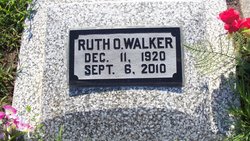
Ruth Olive Cowan Walker
| Birth | : | 11 Dec 1920 Kansas, USA |
| Death | : | 6 Sep 2010 Kansas, USA |
| Burial | : | Kingsthorpe Cemetery, Kingsthorpe, Northampton Borough, England |
| Coordinate | : | 52.2740400, -0.9001200 |
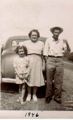
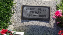
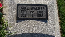
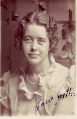
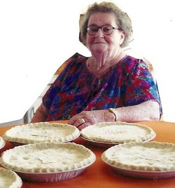
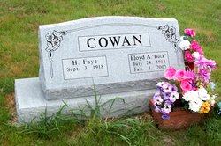
| Description | : | Ruth Olive Walker, age 89, formerly of Mapleton, Kan., and more recently of rural Fort Scott, Kan., died Monday, Sept. 6, 2010, at her home. She was born Dec. 11, 1920, in Hiattville, Kan., the daughter of Oscar Cowan and Grace Olive Boileau Cowan. Ruth married Jake Walker on April 25, 1943, in Fort Scott. He preceded her in death on Oct. 19, 1988. In addition to her husband, she was preceded in death by a son, Robert "Bobby" Walker and wife Nancy, in an automobile accident, a sister, Metta Walker and a brother, Floyd Cowan. |
frequently asked questions (FAQ):
-
Where is Ruth Olive Cowan Walker's memorial?
Ruth Olive Cowan Walker's memorial is located at: Kingsthorpe Cemetery, Kingsthorpe, Northampton Borough, England.
-
When did Ruth Olive Cowan Walker death?
Ruth Olive Cowan Walker death on 6 Sep 2010 in Kansas, USA
-
Where are the coordinates of the Ruth Olive Cowan Walker's memorial?
Latitude: 52.2740400
Longitude: -0.9001200
Family Members:
Parent
Spouse
Siblings

Flowers:


Nearby Cemetories:
1. Kingsthorpe Cemetery
Kingsthorpe, Northampton Borough, England
Coordinate: 52.2740400, -0.9001200
2. St John the Baptist Churchyard
Boughton, Daventry District, England
Coordinate: 52.2861187, -0.8971496
3. Old St John the Baptist Churchyard
Boughton, Daventry District, England
Coordinate: 52.2836464, -0.8801961
4. Dallington Cemetery
Northampton, Northampton Borough, England
Coordinate: 52.2505200, -0.9287200
5. St Botolph Churchyard
Church Brampton, Daventry District, England
Coordinate: 52.2849866, -0.9486724
6. Northampton Gaol Cemetery
Northampton, Northampton Borough, England
Coordinate: 52.2418540, -0.8940440
7. St. Sepulchre Churchyard
Northampton, Northampton Borough, England
Coordinate: 52.2414600, -0.8973600
8. All Saints Churchyard
Pitsford, Daventry District, England
Coordinate: 52.3066700, -0.8952200
9. Cemetery of the Sisters of Notre Dame
Northampton Borough, England
Coordinate: 52.2399000, -0.8923333
10. St Peter and St Paul Churchyard
Abington, Northampton Borough, England
Coordinate: 52.2461580, -0.8653790
11. All Saints Church
Northampton, Northampton Borough, England
Coordinate: 52.2371129, -0.8964385
12. Northampton County Goal Cemetery
Northampton, Northampton Borough, England
Coordinate: 52.2364470, -0.8945440
13. Billing Road Cemetery
Northampton, Northampton Borough, England
Coordinate: 52.2387200, -0.8750900
14. Saint Luke Churchyard
Duston, Northampton Borough, England
Coordinate: 52.2428820, -0.9396550
15. Weston Favel Cemetery
Weston Favell, Northampton Borough, England
Coordinate: 52.2492980, -0.8483410
16. St Michael's Churchyard
Upton, Northampton Borough, England
Coordinate: 52.2356600, -0.9508160
17. Great Billing Churchyard
Northampton, Northampton Borough, England
Coordinate: 52.2581240, -0.8172800
18. All Saints Churchyard Little Billing
Billing, Northampton Borough, England
Coordinate: 52.2484300, -0.8228800
19. Spencer Estate Grounds
Althorp, Daventry District, England
Coordinate: 52.2839190, -0.9889520
20. Great Billing Catholic Cemetery
Billing, Northampton Borough, England
Coordinate: 52.2577300, -0.8130700
21. Towcester Road Cemetery
Far Cotton, Northampton Borough, England
Coordinate: 52.2178190, -0.9117050
22. St Andrew Churchyard
Spratton, Daventry District, England
Coordinate: 52.3243520, -0.9483460
23. St. Mary & All Saints Churchyard
Holcot, Daventry District, England
Coordinate: 52.3208630, -0.8390120
24. All Saints Churchyard
Holdenby, Daventry District, England
Coordinate: 52.3021000, -0.9868100