

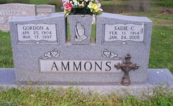
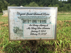
Sadie Helen Cabe Ammons
| Birth | : | 11 Feb 1914 Franklin, Macon County, North Carolina, USA |
| Death | : | 24 Jan 2005 Franklin, Macon County, North Carolina, USA |
| Burial | : | St Sebastian Churchyard, Great Gonerby, South Kesteven District, England |
| Coordinate | : | 52.9329260, -0.6657700 |
| Description | : | Sadie Cabe Ammons Sadie Cabe Ammons, 90, of Ammons Road, Franklin, passed away Monday, Jan. 24, 2005, at a local nursing home. She was a native of Macon County and the daughter of the late Charles Clinton and Mary Ellen Dowdle Cabe. She was married to Gordon Ammons, who passed away March 17, 1997. She was also preceded in death by three brothers, Jake, Lester and C.R. Cabe. She was a homemaker and the oldest member of Clarks Chapel United Methodist Church. She was an avid quilter and did needlework. She was a loving mother and grandmother and was faithful in her church,... Read More |
frequently asked questions (FAQ):
-
Where is Sadie Helen Cabe Ammons's memorial?
Sadie Helen Cabe Ammons's memorial is located at: St Sebastian Churchyard, Great Gonerby, South Kesteven District, England.
-
When did Sadie Helen Cabe Ammons death?
Sadie Helen Cabe Ammons death on 24 Jan 2005 in Franklin, Macon County, North Carolina, USA
-
Where are the coordinates of the Sadie Helen Cabe Ammons's memorial?
Latitude: 52.9329260
Longitude: -0.6657700
Family Members:
Parent

Spouse
Siblings
Children
Flowers:


Nearby Cemetories:
1. St Sebastian Churchyard
Great Gonerby, South Kesteven District, England
Coordinate: 52.9329260, -0.6657700
2. St John the Evangelist Churchyard
Manthorpe, South Kesteven District, England
Coordinate: 52.9306320, -0.6323160
3. Manthorpe Road Old Cemetery
Grantham, South Kesteven District, England
Coordinate: 52.9173900, -0.6409900
4. All Saints Churchyard
Barrowby, South Kesteven District, England
Coordinate: 52.9186420, -0.6946810
5. St. Wulfram Churchyard
Grantham, South Kesteven District, England
Coordinate: 52.9148180, -0.6408520
6. Grantham Cemetery and Crematorium
Grantham, South Kesteven District, England
Coordinate: 52.9095320, -0.6326120
7. St. Peter and St. Paul's Churchyard
Belton, South Kesteven District, England
Coordinate: 52.9451000, -0.6177000
8. St. Lawrence Churchyard
Sedgebrook, South Kesteven District, England
Coordinate: 52.9329460, -0.7256530
9. St Marys Churchyard
Syston, South Kesteven District, England
Coordinate: 52.9578420, -0.6172940
10. St James Churchyard
Allington, South Kesteven District, England
Coordinate: 52.9525695, -0.7245301
11. St Nicholas Churchyard
Barkston, South Kesteven District, England
Coordinate: 52.9629960, -0.6129380
12. St John the Baptist Churchyard
Londonthorpe, South Kesteven District, England
Coordinate: 52.9312060, -0.5837350
13. St Mary and St Peter Churchyard
Harlaxton, South Kesteven District, England
Coordinate: 52.8836860, -0.6895640
14. All Saints Churchyard
Hougham, South Kesteven District, England
Coordinate: 52.9878240, -0.6806910
15. St Peter Churchyard
Foston, South Kesteven District, England
Coordinate: 52.9771630, -0.7227360
16. St. Guthlac Churchyard
Little Ponton, South Kesteven District, England
Coordinate: 52.8796100, -0.6271200
17. St Andrew Churchyard
Denton, South Kesteven District, England
Coordinate: 52.8828830, -0.7151840
18. St John the Baptist Churchyard
Muston, Melton Borough, England
Coordinate: 52.9315700, -0.7680600
19. St. Wilfrid Churchyard
Honington, South Kesteven District, England
Coordinate: 52.9795600, -0.5965700
20. All Saints Churchyard
Stroxton, South Kesteven District, England
Coordinate: 52.8695300, -0.6609700
21. St James Churchyard
Woolsthorpe-by-Belvoir, South Kesteven District, England
Coordinate: 52.8957880, -0.7578370
22. All Saints Churchyard
Westborough, South Kesteven District, England
Coordinate: 52.9892900, -0.7350100
23. St. Mary Magdalene Churchyard
Old Somerby, South Kesteven District, England
Coordinate: 52.8944900, -0.5672830
24. St Swithun Churchyard
Long Bennington, South Kesteven District, England
Coordinate: 52.9856290, -0.7449190