

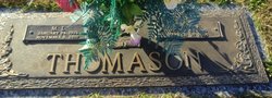
Sara Margaret Reid Thomason
| Birth | : | 19 Aug 1923 |
| Death | : | 27 Mar 2005 |
| Burial | : | Netley Military Cemetery, Netley, Eastleigh Borough, England |
| Coordinate | : | 50.8682632, -1.3317170 |
| Description | : | Source: The Greenville News: 03-28-2005 Mrs. Sara Margaret Thomason, age 81, of Simpsonville, passed away on Easter morning surrounded by her family. A native of Greenville County, she was a daughter of the late Jonas and Margaret Clark Reid. She was a homemaker and longtime member of Unity Baptist Church. She is survived by her loving family, husband, M.L. Thomason, Simpsonville; daughters, Sara Brenda Gerlach and husband Chuck, Dr. J. Myra Sargent; son, Frankie Sargent, all of Atlanta, Ga.; stepson, Ronnie Thomason, Simpsonville; sister, Willie Mae Smith, Summerville; five grandchildren and six great-grandchildren. The family would like to thank... Read More |
frequently asked questions (FAQ):
-
Where is Sara Margaret Reid Thomason's memorial?
Sara Margaret Reid Thomason's memorial is located at: Netley Military Cemetery, Netley, Eastleigh Borough, England.
-
When did Sara Margaret Reid Thomason death?
Sara Margaret Reid Thomason death on 27 Mar 2005 in
-
Where are the coordinates of the Sara Margaret Reid Thomason's memorial?
Latitude: 50.8682632
Longitude: -1.3317170
Family Members:
Parent
Spouse
Siblings
Flowers:


Nearby Cemetories:
1. Netley Military Cemetery
Netley, Eastleigh Borough, England
Coordinate: 50.8682632, -1.3317170
2. St Mary the Virgin Churchyard
Hound, Eastleigh Borough, England
Coordinate: 50.8762820, -1.3322160
3. St Andrew the Apostle Churchyard
Hamble-le-Rice, Eastleigh Borough, England
Coordinate: 50.8589100, -1.3179090
4. St. Leonard Churchyard
Bursledon, Eastleigh Borough, England
Coordinate: 50.8850230, -1.3068370
5. Holly Hill Cemetery
Sarisbury, Fareham Borough, England
Coordinate: 50.8678930, -1.2888890
6. St Paul Churchyard
Sarisbury, Fareham Borough, England
Coordinate: 50.8756100, -1.2870670
7. St Mary Extra Cemetery
Southampton, Southampton Unitary Authority, England
Coordinate: 50.8948700, -1.3522600
8. Holy Trinity Churchyard
Southampton, Southampton Unitary Authority, England
Coordinate: 50.8896750, -1.3659150
9. St Mary Churchyard
Warsash, Fareham Borough, England
Coordinate: 50.8473220, -1.2910610
10. St Mary Churchyard
Sholing, Southampton Unitary Authority, England
Coordinate: 50.8991260, -1.3571350
11. All Saints Churchyard
Fawley, New Forest District, England
Coordinate: 50.8297700, -1.3522200
12. Albert Road Cemetery
Hedge End, Eastleigh Borough, England
Coordinate: 50.9066535, -1.3099266
13. St John the Baptist Churchyard
Hythe, New Forest District, England
Coordinate: 50.8688500, -1.3985000
14. St John's Cemetery
Locks Heath, Fareham Borough, England
Coordinate: 50.8608400, -1.2651570
15. St John the Evangelist Churchyard
Hedge End, Eastleigh Borough, England
Coordinate: 50.9089200, -1.3091100
16. St. Mary Extra Churchyard
Southampton, Southampton Unitary Authority, England
Coordinate: 50.9040000, -1.3743000
17. Waterside Methodist Chapelyard
Fawley, New Forest District, England
Coordinate: 50.8245300, -1.3597900
18. Holy Saviour Churchyard
Bitterne, Southampton Unitary Authority, England
Coordinate: 50.9138840, -1.3583560
19. Redcote Convent Cemetery
Bitterne, Southampton Unitary Authority, England
Coordinate: 50.9168600, -1.3510700
20. St Bartholomew Churchyard
Botley, Eastleigh Borough, England
Coordinate: 50.9048000, -1.2754000
21. St Mary Churchyard
Southampton, Southampton Unitary Authority, England
Coordinate: 50.9027100, -1.3960800
22. St. Julien's Church
Southampton, Southampton Unitary Authority, England
Coordinate: 50.8965000, -1.4036000
23. St Lawrence with St John Churchyard
Southampton, Southampton Unitary Authority, England
Coordinate: 50.8977570, -1.4052470
24. Holyrood Churchyard
Southampton, Southampton Unitary Authority, England
Coordinate: 50.8996600, -1.4035300