
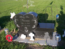
Shirley Ann Wolke Noonan
| Birth | : | 4 Aug 1937 Conway Springs, Sumner County, Kansas, USA |
| Death | : | 12 Jan 2008 Burlingame, Osage County, Kansas, USA |
| Burial | : | New Perrysville Cemetery, Perrysville, Carroll County, USA |
| Coordinate | : | 40.4569016, -81.1016998 |
| Description | : | Shirley Ann Noonan, 70, Burlingame, passed away Saturday, January 12, 2008, at her home. She was born August 4, 1937, at Conway Springs, Kansas, to George and Bernetta Hommertzeim Wolke. She graduated from Conway Springs High School in 1955. She married Charles Noonan, September 1, 1956. They moved to the Burlingame area in 1962. They were divorced in October 1976. Shirley was a cook for the Burlingame School District for 27 years, retiring in May 1999. She was a member of St. Patrick's Catholic Church. She was preceded in death by her parents, a sister, Dianne Metzen, and a grandson,... Read More |
frequently asked questions (FAQ):
-
Where is Shirley Ann Wolke Noonan's memorial?
Shirley Ann Wolke Noonan's memorial is located at: New Perrysville Cemetery, Perrysville, Carroll County, USA.
-
When did Shirley Ann Wolke Noonan death?
Shirley Ann Wolke Noonan death on 12 Jan 2008 in Burlingame, Osage County, Kansas, USA
-
Where are the coordinates of the Shirley Ann Wolke Noonan's memorial?
Latitude: 40.4569016
Longitude: -81.1016998
Family Members:


Flowers:


Nearby Cemetories:
1. New Perrysville Cemetery
Perrysville, Carroll County, USA
Coordinate: 40.4569016, -81.1016998
2. Hagey Family Cemetery
Perrysville, Carroll County, USA
Coordinate: 40.4525980, -81.0996160
3. Perrysville United Methodist Cemetery
Perrysville, Carroll County, USA
Coordinate: 40.4625510, -81.0973610
4. Perrysville Methodist Episcopal Church Cemetery
Perrysville, Carroll County, USA
Coordinate: 40.4655991, -81.0982971
5. Mount Olive Cemetery
Carroll County, USA
Coordinate: 40.4488983, -81.1382980
6. Arabia Cemetery
Perrysville, Carroll County, USA
Coordinate: 40.4803009, -81.0678024
7. Mount Tabor Cemetery
Carroll County, USA
Coordinate: 40.4817009, -81.1483002
8. Allen Memorial Cemetery
Carroll County, USA
Coordinate: 40.4364014, -81.0511017
9. Wood Cemetery
Scio, Harrison County, USA
Coordinate: 40.4193500, -81.0707690
10. Palermo Cemetery
Carroll County, USA
Coordinate: 40.4894444, -81.1522220
11. Swinehart Cemetery
Carroll County, USA
Coordinate: 40.4327000, -81.1642170
12. Conotton Cemetery
Harrison County, USA
Coordinate: 40.4103012, -81.1489029
13. Methodist Episcopal Church Cemetery
Scio, Harrison County, USA
Coordinate: 40.3970800, -81.0864600
14. Grandview Cemetery
Scio, Harrison County, USA
Coordinate: 40.3903008, -81.0978012
15. Mount Pleasant Cemetery
Carrollton, Carroll County, USA
Coordinate: 40.5238991, -81.1003036
16. New Hagerstown Cemetery
New Hagerstown, Carroll County, USA
Coordinate: 40.4446983, -81.1893997
17. Abel Cemetery
Carroll County, USA
Coordinate: 40.4578018, -81.0113983
18. Longview Cemetery
Bowerston, Harrison County, USA
Coordinate: 40.4324989, -81.1872025
19. Bethel Cemetery
Leavittsville, Carroll County, USA
Coordinate: 40.4921989, -81.1841965
20. United Brethren Cemetery
Harrison County, USA
Coordinate: 40.4043999, -81.0353012
21. New Rumley Methodist Cemetery
New Rumley, Harrison County, USA
Coordinate: 40.4028015, -81.0346985
22. Kilgore Cemetery
Kilgore, Carroll County, USA
Coordinate: 40.4632988, -81.0014038
23. Kilgore Presbyterian Cemetery
Carroll County, USA
Coordinate: 40.4603004, -81.0002975
24. Evangelical Lutheran Cemetery
New Rumley, Harrison County, USA
Coordinate: 40.4019012, -81.0271988