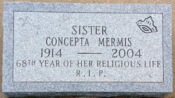
Sr Concepta Mermis
| Birth | : | 30 Jan 1914 Gorham, Russell County, Kansas, USA |
| Death | : | 29 Sep 2004 Concordia, Cloud County, Kansas, USA |
| Burial | : | St Leonard Churchyard, Walton-le-Dale, South Ribble Borough, England |
| Coordinate | : | 53.7476530, -2.6666950 |
| Description | : | Sister Concepta Mermis, 90, died Sept. 29, 2004, at Cloud County Health Center. She had been a Sister of St. Joseph for 67 years. She was born in Gorham, Jan. 30, 1914, to Alex and Brigitta Heile Mermis and was baptized Loretta. She entered the Sisters of St. Joseph, Concordia, Jan. 27, 1937. On August 15, 1937, Loretta received the habit of the Sisters of St. Joseph and was given the name Sister Concepta. She pronounced first vows on Aug. 15, 1938, and final vows on Aug. 15, 1941. From 1938 to 1987,... Read More |
frequently asked questions (FAQ):
-
Where is Sr Concepta Mermis's memorial?
Sr Concepta Mermis's memorial is located at: St Leonard Churchyard, Walton-le-Dale, South Ribble Borough, England.
-
When did Sr Concepta Mermis death?
Sr Concepta Mermis death on 29 Sep 2004 in Concordia, Cloud County, Kansas, USA
-
Where are the coordinates of the Sr Concepta Mermis's memorial?
Latitude: 53.7476530
Longitude: -2.6666950
Family Members:
Parent
Siblings
Flowers:
Nearby Cemetories:
1. St Leonard Churchyard
Walton-le-Dale, South Ribble Borough, England
Coordinate: 53.7476530, -2.6666950
2. St Augustine of Canterbury
Preston, City of Preston, England
Coordinate: 53.7560420, -2.6912650
3. All Saints Churchyard
Walton-le-Dale, South Ribble Borough, England
Coordinate: 53.7407250, -2.6408280
4. Our Lady and St Patrick's Church
Walton-le-Dale, South Ribble Borough, England
Coordinate: 53.7407250, -2.6408280
5. St Mary's Churchyard Brownedge
Bamber Bridge, South Ribble Borough, England
Coordinate: 53.7305472, -2.6669416
6. St. James' Churchyard
Preston, City of Preston, England
Coordinate: 53.7566010, -2.6941110
7. St John Churchyard
Preston, City of Preston, England
Coordinate: 53.7582080, -2.6959750
8. Preston Old Cemetery
Ribbleton, City of Preston, England
Coordinate: 53.7686352, -2.6623154
9. St. Paul Churchyard
Preston, City of Preston, England
Coordinate: 53.7625360, -2.6947080
10. St. Ignatius RC Churchyard
Preston, City of Preston, England
Coordinate: 53.7635270, -2.6965870
11. St. George the Martyr
Preston, City of Preston, England
Coordinate: 53.7591220, -2.7025660
12. Preston New Cemetery
Ribbleton, City of Preston, England
Coordinate: 53.7717400, -2.6620900
13. St. Wilfrid's Catholic Cemetery
Preston, City of Preston, England
Coordinate: 53.7581670, -2.7044930
14. Our Lady and Saint Gerards Churchyard
Lostock Hall, South Ribble Borough, England
Coordinate: 53.7279090, -2.6921460
15. Friends Meeting House Burial Ground (Defunct)
Preston, City of Preston, England
Coordinate: 53.7610250, -2.7030380
16. Holy Trinity
Preston, City of Preston, England
Coordinate: 53.7613030, -2.7030580
17. Christ Church Churchyard
Preston, City of Preston, England
Coordinate: 53.7573210, -2.7103080
18. Grey Friars' Church
Preston, City of Preston, England
Coordinate: 53.7601480, -2.7084600
19. St. Saviour's Churchyard
Bamber Bridge, South Ribble Borough, England
Coordinate: 53.7197301, -2.6598985
20. Saint Peter Churchyard
Preston, City of Preston, England
Coordinate: 53.7634100, -2.7080700
21. Penwortham Cemetery
Penwortham, South Ribble Borough, England
Coordinate: 53.7452590, -2.7209190
22. St Walburge's RC Church
Preston, City of Preston, England
Coordinate: 53.7629690, -2.7149620
23. St. Leonard the Less Churchyard
Samlesbury, South Ribble Borough, England
Coordinate: 53.7680000, -2.6237000
24. St Mary Churchyard
Penwortham, South Ribble Borough, England
Coordinate: 53.7551800, -2.7234210


