
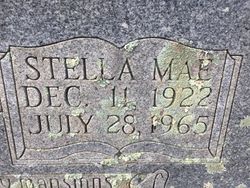


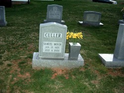
Stella Mae Culler Hiatt
| Birth | : | 11 Dec 1922 Carroll County, Virginia, USA |
| Death | : | 28 Jul 1965 Pulaski County, Virginia, USA |
| Burial | : | Grantham Cemetery and Crematorium, Grantham, South Kesteven District, England |
| Coordinate | : | 52.9095320, -0.6326120 |
frequently asked questions (FAQ):
-
Where is Stella Mae Culler Hiatt's memorial?
Stella Mae Culler Hiatt's memorial is located at: Grantham Cemetery and Crematorium, Grantham, South Kesteven District, England.
-
When did Stella Mae Culler Hiatt death?
Stella Mae Culler Hiatt death on 28 Jul 1965 in Pulaski County, Virginia, USA
-
Where are the coordinates of the Stella Mae Culler Hiatt's memorial?
Latitude: 52.9095320
Longitude: -0.6326120
Family Members:
Parent

Spouse
Siblings

Children
Flowers:


Nearby Cemetories:
1. Grantham Cemetery and Crematorium
Grantham, South Kesteven District, England
Coordinate: 52.9095320, -0.6326120
2. St. Wulfram Churchyard
Grantham, South Kesteven District, England
Coordinate: 52.9148180, -0.6408520
3. Manthorpe Road Old Cemetery
Grantham, South Kesteven District, England
Coordinate: 52.9173900, -0.6409900
4. St John the Evangelist Churchyard
Manthorpe, South Kesteven District, England
Coordinate: 52.9306320, -0.6323160
5. St. Guthlac Churchyard
Little Ponton, South Kesteven District, England
Coordinate: 52.8796100, -0.6271200
6. St Sebastian Churchyard
Great Gonerby, South Kesteven District, England
Coordinate: 52.9329260, -0.6657700
7. St John the Baptist Churchyard
Londonthorpe, South Kesteven District, England
Coordinate: 52.9312060, -0.5837350
8. St. Peter and St. Paul's Churchyard
Belton, South Kesteven District, England
Coordinate: 52.9451000, -0.6177000
9. All Saints Churchyard
Barrowby, South Kesteven District, England
Coordinate: 52.9186420, -0.6946810
10. St. Mary Magdalene Churchyard
Old Somerby, South Kesteven District, England
Coordinate: 52.8944900, -0.5672830
11. St Mary and St Peter Churchyard
Harlaxton, South Kesteven District, England
Coordinate: 52.8836860, -0.6895640
12. All Saints Churchyard
Stroxton, South Kesteven District, England
Coordinate: 52.8695300, -0.6609700
13. Holy Cross Churchyard
Great Ponton, South Kesteven District, England
Coordinate: 52.8638270, -0.6275570
14. St Marys Churchyard
Syston, South Kesteven District, England
Coordinate: 52.9578420, -0.6172940
15. St Nicholas Churchyard
Barkston, South Kesteven District, England
Coordinate: 52.9629960, -0.6129380
16. St Andrew Churchyard
Denton, South Kesteven District, England
Coordinate: 52.8828830, -0.7151840
17. St. Lawrence Churchyard
Sedgebrook, South Kesteven District, England
Coordinate: 52.9329460, -0.7256530
18. Saint Andrew Churchyard
Boothby Pagnell, South Kesteven District, England
Coordinate: 52.8660600, -0.5578600
19. St. Peter's Churchyard
Ropsley, South Kesteven District, England
Coordinate: 52.8959736, -0.5259958
20. Ropsley Churchyard Extension
Ropsley, South Kesteven District, England
Coordinate: 52.8958475, -0.5254147
21. St James Churchyard
Allington, South Kesteven District, England
Coordinate: 52.9525695, -0.7245301
22. St. Wilfrid Churchyard
Honington, South Kesteven District, England
Coordinate: 52.9795600, -0.5965700
23. St Thomas a Beckett Churchyard
Bassingthorpe, South Kesteven District, England
Coordinate: 52.8457500, -0.5669900
24. St James Churchyard
Woolsthorpe-by-Belvoir, South Kesteven District, England
Coordinate: 52.8957880, -0.7578370