

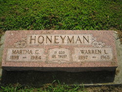
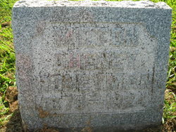
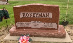
Warren L. Honeyman
| Birth | : | 9 Feb 1897 Mills County, Iowa, USA |
| Death | : | 28 Apr 1968 Emerson, Mills County, Iowa, USA |
| Burial | : | St Peter Churchyard, Needham, South Norfolk District, England |
| Coordinate | : | 52.3896320, 1.2773700 |
| Plot | : | Original Section #60 |
| Description | : | Funeral services for Warren L. Honeyman, 71, retired farmer, were held Wednesday, May 1, at 2:30 p.m. at the Methodist church in Emerson with the Rev. Earl Kelly in charge. Mr. Honeyman, a lifetime resident of the Emerson community, passed away Sunday morning, April 28, at his home here. The son of Mr. and Mrs. John Honeyman, he was born Feb. 9, 1897, in Mills county and was married in 1933 to Martha Bass, who survives. Others who survive include a son, Lee Honeyman; two stepsons George J. Bass of Emerson and Rev. Wayne Bass of Salem, Ore.; two stepdaughters... Read More |
frequently asked questions (FAQ):
-
Where is Warren L. Honeyman's memorial?
Warren L. Honeyman's memorial is located at: St Peter Churchyard, Needham, South Norfolk District, England.
-
When did Warren L. Honeyman death?
Warren L. Honeyman death on 28 Apr 1968 in Emerson, Mills County, Iowa, USA
-
Where are the coordinates of the Warren L. Honeyman's memorial?
Latitude: 52.3896320
Longitude: 1.2773700
Family Members:
Parent

Spouse
Siblings

Children
Flowers:


Nearby Cemetories:
1. St Peter Churchyard
Needham, South Norfolk District, England
Coordinate: 52.3896320, 1.2773700
2. St Mary Churchyard
Dickleburgh and Rushall, South Norfolk District, England
Coordinate: 52.3978750, 1.2290680
3. St. Peter and St. Paul Churchyard
Brockdish, South Norfolk District, England
Coordinate: 52.3705240, 1.2366100
4. St Mary the Virgin Churchyard
Pulham St Mary, South Norfolk District, England
Coordinate: 52.4205290, 1.2520380
5. St. Margaret's Churchyard
Syleham, Mid Suffolk District, England
Coordinate: 52.3641870, 1.2372060
6. All Saints Churchyard
Mendham, Mid Suffolk District, England
Coordinate: 52.3976310, 1.3349670
7. Church of the Assumption of the Blessed Virgin Mar
Redenhall, South Norfolk District, England
Coordinate: 52.4104780, 1.3272680
8. Fressingfield Methodist Churchyard
Fressingfield, Mid Suffolk District, England
Coordinate: 52.3472430, 1.3133970
9. St. Peter and St. Paul Churchyard
Fressingfield, Mid Suffolk District, England
Coordinate: 52.3487940, 1.3190390
10. Saint Mary Magdalene Churchyard
Metfield, Mid Suffolk District, England
Coordinate: 52.3773540, 1.3538467
11. Pulham Market Cemetery
Pulham Market, South Norfolk District, England
Coordinate: 52.4281900, 1.2297700
12. Saint Mary Magdalene Churchyard
Pulham Market, South Norfolk District, England
Coordinate: 52.4285200, 1.2301100
13. Baptist Churchyard
Fressingfield, Mid Suffolk District, England
Coordinate: 52.3481570, 1.3216200
14. Fressingfield Cemetery
Fressingfield, Mid Suffolk District, England
Coordinate: 52.3392240, 1.3135440
15. All Saints Churchyard
Dickleburgh and Rushall, South Norfolk District, England
Coordinate: 52.3968580, 1.1848010
16. Metfield Cemetery
Metfield, Mid Suffolk District, England
Coordinate: 52.3678410, 1.3635810
17. Saint Mary Churchyard
Homersfield, Waveney District, England
Coordinate: 52.4191670, 1.3595410
18. Saint John the Baptist Churchyard
Metfield, Mid Suffolk District, England
Coordinate: 52.3728810, 1.3689930
19. Saint Peter and St. Paul Churchyard
Hoxne, Mid Suffolk District, England
Coordinate: 52.3522270, 1.2016300
20. All Saints Churchyard
Alburgh, South Norfolk District, England
Coordinate: 52.4362610, 1.3386490
21. St Leonard Churchyard
Billingford, South Norfolk District, England
Coordinate: 52.3666290, 1.1834260
22. St George's Churchyard
South Elmham St Cross, Waveney District, England
Coordinate: 52.4080410, 1.3794272
23. St. George's Churchyard
Shimpling, Babergh District, England
Coordinate: 52.3994010, 1.1680910
24. Saint George Churchyard
Shimpling, South Norfolk District, England
Coordinate: 52.3993000, 1.1680000