
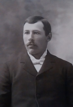
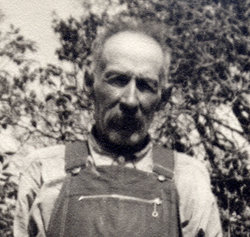
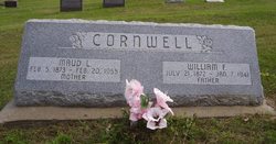
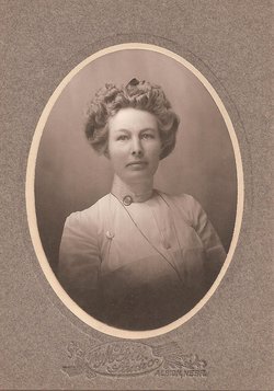
William Frederick Cornwell
| Birth | : | 21 Jul 1872 Cleveland, Cuyahoga County, Ohio, USA |
| Death | : | 7 Jan 1941 Saint Edward, Boone County, Nebraska, USA |
| Burial | : | Golden Gate Mausoleum and Columbaria, El Cerrito, Contra Costa County, USA |
| Coordinate | : | 37.9073150, -122.2857220 |
| Description | : | WM. CORNWELL DIES AT ST. EDWARD William Cornwell, 70 (68), a long time resident of the Plum Creek community passed away at the Sullivan hospital in St. Edward at 4:45 Tuesday afternoon. He had submitted to an emergency operation for an intestinal obstruction on December 21. Death resulted from peritonitis and complications. He is survived by his wife and several children. Funeral arrangements were awaiting word from a son who resides in Pennsylvania. An obituary will be published in the News next week. Albion News, Albion, Nebraska SERVICES FOR W. F. CORNWELL HELD FRIDAY Rites... Read More |
frequently asked questions (FAQ):
-
Where is William Frederick Cornwell's memorial?
William Frederick Cornwell's memorial is located at: Golden Gate Mausoleum and Columbaria, El Cerrito, Contra Costa County, USA.
-
When did William Frederick Cornwell death?
William Frederick Cornwell death on 7 Jan 1941 in Saint Edward, Boone County, Nebraska, USA
-
Where are the coordinates of the William Frederick Cornwell's memorial?
Latitude: 37.9073150
Longitude: -122.2857220
Family Members:
Parent


Spouse
Siblings

Children


Flowers:


Nearby Cemetories:
1. Sunset View Cemetery
El Cerrito, Contra Costa County, USA
Coordinate: 37.9077721, -122.2871017
2. Northbrae Community Church Columbarium
Berkeley, Alameda County, USA
Coordinate: 37.8905500, -122.2763200
3. Golden Gate Fields
Albany, Alameda County, USA
Coordinate: 37.8854000, -122.3117000
4. Salesian Cemetery
Richmond, Contra Costa County, USA
Coordinate: 37.9532650, -122.3401230
5. Saint Joseph Catholic Cemetery
San Pablo, Contra Costa County, USA
Coordinate: 37.9612700, -122.3336600
6. Saint Pauls Cemetery (Defunct)
San Pablo, Contra Costa County, USA
Coordinate: 37.9563332, -122.3430099
7. Rolling Hills Memorial Park
Richmond, Contra Costa County, USA
Coordinate: 37.9756012, -122.3146973
8. Saint Mary's Cemetery
Oakland, Alameda County, USA
Coordinate: 37.8349991, -122.2418976
9. Home of Eternity Cemetery
Oakland, Alameda County, USA
Coordinate: 37.8322970, -122.2448270
10. Chapel of the Chimes Columbarium and Mausoleum
Oakland, Alameda County, USA
Coordinate: 37.8318863, -122.2456894
11. Chapel of Memories Columbarium
Oakland, Alameda County, USA
Coordinate: 37.8310471, -122.2480927
12. Mountain View Cemetery
Oakland, Alameda County, USA
Coordinate: 37.8327600, -122.2395200
13. Gan Shalom Cemetery
Contra Costa County, USA
Coordinate: 37.9528122, -122.1975098
14. Saint Stephens Episcopal Church Memorial Garden
Orinda, Contra Costa County, USA
Coordinate: 37.8982650, -122.1729170
15. Cathedral of Christ the Light Mausoleum
Oakland, Alameda County, USA
Coordinate: 37.8105316, -122.2633896
16. Lafayette-Orinda Presbyterian Church Garden
Contra Costa County, USA
Coordinate: 37.8866040, -122.1606950
17. Yerba Buena Island Cemetery (Defunct)
San Francisco, San Francisco County, USA
Coordinate: 37.8127420, -122.3707880
18. Saint Paul Lutheran Church
Oakland, Alameda County, USA
Coordinate: 37.8020820, -122.2222780
19. Angel Island Cemetery (defunct)
Tiburon, Marin County, USA
Coordinate: 37.8621830, -122.4325920
20. Home of Peace Cemetery
Oakland, Alameda County, USA
Coordinate: 37.7790604, -122.2036285
21. Muir-Strentzel Hanna Cemetery
Martinez, Contra Costa County, USA
Coordinate: 37.9784393, -122.1232681
22. Queen of Heaven Cemetery
Lafayette, Contra Costa County, USA
Coordinate: 37.9446983, -122.1057968
23. First Street Cemetery (Defunct)
San Francisco, San Francisco County, USA
Coordinate: 37.7906170, -122.3991770
24. Bush Street Cemetery (Defunct)
San Francisco, San Francisco County, USA
Coordinate: 37.7907950, -122.4011960