
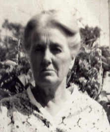

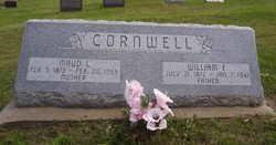
Maud Lena McBride Cornwell
| Birth | : | 5 Feb 1873 Delaware County, Iowa, USA |
| Death | : | 20 Feb 1955 Galax, Galax City, Virginia, USA |
| Burial | : | Golden Gate Mausoleum and Columbaria, El Cerrito, Contra Costa County, USA |
| Coordinate | : | 37.9073150, -122.2857220 |
| Description | : | Mrs. Cornwell funeral rites were Friday Mrs. Maud Lena Cornwell, daughter of Benjamin F. and Phebe Dufoe McBride, was born in Delaware county, Iowa, Feb. 5, 1873. She died at the home of her son Benjamin in Galax, Va., Feb 20, 1955, at the age of 82. When she was four months old, she came with her parent to Boone county by covered wagon. The crossing of the Missouri river at that time was difficult and hazardous, but the McBrides pressed on and settled on what is known as the McBride homestead, four miles north of Belgrade. Mrs. Cornwell became... Read More |
frequently asked questions (FAQ):
-
Where is Maud Lena McBride Cornwell's memorial?
Maud Lena McBride Cornwell's memorial is located at: Golden Gate Mausoleum and Columbaria, El Cerrito, Contra Costa County, USA.
-
When did Maud Lena McBride Cornwell death?
Maud Lena McBride Cornwell death on 20 Feb 1955 in Galax, Galax City, Virginia, USA
-
Where are the coordinates of the Maud Lena McBride Cornwell's memorial?
Latitude: 37.9073150
Longitude: -122.2857220
Family Members:
Parent
Spouse
Siblings

Children


Flowers:


Nearby Cemetories:
1. Sunset View Cemetery
El Cerrito, Contra Costa County, USA
Coordinate: 37.9077721, -122.2871017
2. Northbrae Community Church Columbarium
Berkeley, Alameda County, USA
Coordinate: 37.8905500, -122.2763200
3. Golden Gate Fields
Albany, Alameda County, USA
Coordinate: 37.8854000, -122.3117000
4. Salesian Cemetery
Richmond, Contra Costa County, USA
Coordinate: 37.9532650, -122.3401230
5. Saint Joseph Catholic Cemetery
San Pablo, Contra Costa County, USA
Coordinate: 37.9612700, -122.3336600
6. Saint Pauls Cemetery (Defunct)
San Pablo, Contra Costa County, USA
Coordinate: 37.9563332, -122.3430099
7. Rolling Hills Memorial Park
Richmond, Contra Costa County, USA
Coordinate: 37.9756012, -122.3146973
8. Saint Mary's Cemetery
Oakland, Alameda County, USA
Coordinate: 37.8349991, -122.2418976
9. Home of Eternity Cemetery
Oakland, Alameda County, USA
Coordinate: 37.8322970, -122.2448270
10. Chapel of the Chimes Columbarium and Mausoleum
Oakland, Alameda County, USA
Coordinate: 37.8318863, -122.2456894
11. Chapel of Memories Columbarium
Oakland, Alameda County, USA
Coordinate: 37.8310471, -122.2480927
12. Mountain View Cemetery
Oakland, Alameda County, USA
Coordinate: 37.8327600, -122.2395200
13. Gan Shalom Cemetery
Contra Costa County, USA
Coordinate: 37.9528122, -122.1975098
14. Saint Stephens Episcopal Church Memorial Garden
Orinda, Contra Costa County, USA
Coordinate: 37.8982650, -122.1729170
15. Cathedral of Christ the Light Mausoleum
Oakland, Alameda County, USA
Coordinate: 37.8105316, -122.2633896
16. Lafayette-Orinda Presbyterian Church Garden
Contra Costa County, USA
Coordinate: 37.8866040, -122.1606950
17. Yerba Buena Island Cemetery (Defunct)
San Francisco, San Francisco County, USA
Coordinate: 37.8127420, -122.3707880
18. Saint Paul Lutheran Church
Oakland, Alameda County, USA
Coordinate: 37.8020820, -122.2222780
19. Angel Island Cemetery (defunct)
Tiburon, Marin County, USA
Coordinate: 37.8621830, -122.4325920
20. Home of Peace Cemetery
Oakland, Alameda County, USA
Coordinate: 37.7790604, -122.2036285
21. Muir-Strentzel Hanna Cemetery
Martinez, Contra Costa County, USA
Coordinate: 37.9784393, -122.1232681
22. Queen of Heaven Cemetery
Lafayette, Contra Costa County, USA
Coordinate: 37.9446983, -122.1057968
23. First Street Cemetery (Defunct)
San Francisco, San Francisco County, USA
Coordinate: 37.7906170, -122.3991770
24. Bush Street Cemetery (Defunct)
San Francisco, San Francisco County, USA
Coordinate: 37.7907950, -122.4011960