
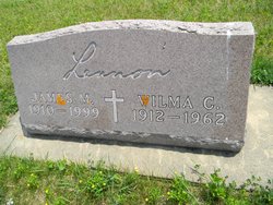
Wilma Clair Haining Lennon
| Birth | : | 26 Jan 1912 St. Louis County, Minnesota, USA |
| Death | : | 6 Jul 1961 |
| Burial | : | Saint Anne's Church, Woodplumpton, City of Preston, England |
| Coordinate | : | 53.8038130, -2.7621940 |
| Description | : | Daughter of John Haining and Mattie Show. She was educated in the schools of Duluth, Minnesota and graduated from high school at Staples, Minnesota. Following graduation she entered nurses' training at the University of Minnesota and the General Hospital in Minneapolis. She worked at the Postville Community Hospital for a number of years, and later at the Postville Farmer's Telephone Company. She was married to James Lennon on August 4, 1940. They made their home in the Postville and Clermont area. They were the parents of Mary Louise. |
frequently asked questions (FAQ):
-
Where is Wilma Clair Haining Lennon's memorial?
Wilma Clair Haining Lennon's memorial is located at: Saint Anne's Church, Woodplumpton, City of Preston, England.
-
When did Wilma Clair Haining Lennon death?
Wilma Clair Haining Lennon death on 6 Jul 1961 in
-
Where are the coordinates of the Wilma Clair Haining Lennon's memorial?
Latitude: 53.8038130
Longitude: -2.7621940
Family Members:
Spouse

Flowers:


Nearby Cemetories:
1. Saint Anne's Church
Woodplumpton, City of Preston, England
Coordinate: 53.8038130, -2.7621940
2. St Andrew George Haydock Roman Catholic Churchyard
Cottam, City of Preston, England
Coordinate: 53.7879280, -2.7591570
3. St Mary's Newhouse
Barton, City of Preston, England
Coordinate: 53.8205240, -2.7406500
4. St. John Baptist Churchyard
Broughton-in-Amounderness, City of Preston, England
Coordinate: 53.8033700, -2.7170400
5. St. Lawrence Churchyard
Barton, City of Preston, England
Coordinate: 53.8289213, -2.7366654
6. St. Mary's Churchyard
Lea, City of Preston, England
Coordinate: 53.7733810, -2.7942770
7. St. Andrew's Churchyard
Ashton-on-Ribble, City of Preston, England
Coordinate: 53.7687030, -2.7359180
8. St. John the Evangelist Churchyard
Clifton, Fylde Borough, England
Coordinate: 53.7758600, -2.8158500
9. Christ Church Churchyard
Fulwood, City of Preston, England
Coordinate: 53.7771920, -2.7028700
10. St. Peters Churchyard
Inskip with Sowerby, Wyre Borough, England
Coordinate: 53.8347100, -2.8175200
11. Christ Churchyard
Treales, Fylde Borough, England
Coordinate: 53.8045970, -2.8440710
12. St Walburge's RC Church
Preston, City of Preston, England
Coordinate: 53.7629690, -2.7149620
13. St. Mary's Churchyard
Preston, City of Preston, England
Coordinate: 53.8010830, -2.6779600
14. St. Hilda's Churchyard
Bilsborrow, Wyre Borough, England
Coordinate: 53.8522170, -2.7420090
15. Inskip Baptist Churchyard
Inskip with Sowerby, Wyre Borough, England
Coordinate: 53.8353150, -2.8299610
16. Saint Peter Churchyard
Preston, City of Preston, England
Coordinate: 53.7634100, -2.7080700
17. St Mary Churchyard
Penwortham, South Ribble Borough, England
Coordinate: 53.7551800, -2.7234210
18. Grey Friars' Church
Preston, City of Preston, England
Coordinate: 53.7601480, -2.7084600
19. Holy Trinity
Preston, City of Preston, England
Coordinate: 53.7613030, -2.7030580
20. Friends Meeting House Burial Ground (Defunct)
Preston, City of Preston, England
Coordinate: 53.7610250, -2.7030380
21. Christ Church Churchyard
Preston, City of Preston, England
Coordinate: 53.7573210, -2.7103080
22. St. Ignatius RC Churchyard
Preston, City of Preston, England
Coordinate: 53.7635270, -2.6965870
23. St. George the Martyr
Preston, City of Preston, England
Coordinate: 53.7591220, -2.7025660
24. St. Wilfrid's Catholic Cemetery
Preston, City of Preston, England
Coordinate: 53.7581670, -2.7044930