


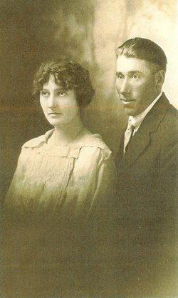
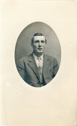
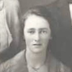
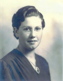
Wilma Glee Hankins Hare
| Birth | : | 21 Oct 1899 Sheridan County, Nebraska, USA |
| Death | : | 9 Mar 1932 Rushville, Sheridan County, Nebraska, USA |
| Burial | : | St Andrew Churchyard, Weaverthorpe, Ryedale District, England |
| Coordinate | : | 54.1267400, -0.5226800 |
| Description | : | Obituary: Wilma Glee Hankins was born on October 21st, 1899 on a farm north of Hay Springs, Nebraska. She died in the hospital in Rushville, Nebraska on March 9th, 1932, being at the time of her death 32 years, 4 months and 19 days of age. On October 6th, 1921, she was united in marriage to James Walter Hare, and to this union were born four children. She leaves to mourn her death, her husband, James W. Hare; her children: Bernice, age 10; Dean, age eight; Sylivia, age six; Jerene, age three. Also her father and mother, Ed... Read More |
frequently asked questions (FAQ):
-
Where is Wilma Glee Hankins Hare's memorial?
Wilma Glee Hankins Hare's memorial is located at: St Andrew Churchyard, Weaverthorpe, Ryedale District, England.
-
When did Wilma Glee Hankins Hare death?
Wilma Glee Hankins Hare death on 9 Mar 1932 in Rushville, Sheridan County, Nebraska, USA
-
Where are the coordinates of the Wilma Glee Hankins Hare's memorial?
Latitude: 54.1267400
Longitude: -0.5226800
Family Members:
Parent
Spouse
Siblings
Children

Flowers:


Nearby Cemetories:
1. St Andrew Churchyard
Weaverthorpe, Ryedale District, England
Coordinate: 54.1267400, -0.5226800
2. St Nicholas Churchyard
Foxholes, Ryedale District, England
Coordinate: 54.1297000, -0.4843000
3. St. Mary's Church Luttons Ambo
West Lutton, Ryedale District, England
Coordinate: 54.1105340, -0.5779463
4. Octon Crematorium
Langtoft, East Riding of Yorkshire Unitary Authority, England
Coordinate: 54.1089720, -0.4506760
5. St. Mary Churchyard
Cowlam, East Riding of Yorkshire Unitary Authority, England
Coordinate: 54.0787700, -0.5292200
6. St. Hilda Churchyard
Sherburn, Ryedale District, England
Coordinate: 54.1837400, -0.5311200
7. Cottam Church
Cottam, East Riding of Yorkshire Unitary Authority, England
Coordinate: 54.0707320, -0.4833770
8. St. Andrew's Churchyard
East Heslerton, Ryedale District, England
Coordinate: 54.1772500, -0.5825000
9. St Nicholas Churchyard
Ganton, Ryedale District, England
Coordinate: 54.1846000, -0.4846000
10. St. Andrew's Churchyard
Kirby Grindalythe, Ryedale District, England
Coordinate: 54.0955440, -0.6200050
11. All Saints Churchyard
West Heslerton, Ryedale District, England
Coordinate: 54.1704100, -0.6057100
12. St Peter Churchyard
Wintringham, Ryedale District, England
Coordinate: 54.1467660, -0.6431680
13. St. Peter's Churchyard
Willerby, Ryedale District, England
Coordinate: 54.1984200, -0.4558500
14. Fordon Churchyard
East Riding of Yorkshire Unitary Authority, England
Coordinate: 54.1610140, -0.3939100
15. All Saints Church Cemetery
Brompton-by-Sawdon, Scarborough Borough, England
Coordinate: 54.2223100, -0.5500900
16. All Saints' Churchyard
Thorpe Bassett, Ryedale District, England
Coordinate: 54.1496503, -0.6875921
17. St. John the Baptist Churchyard
Yedingham, Ryedale District, England
Coordinate: 54.2041744, -0.6320491
18. All Saints Churchyard
Brompton-by-Sawdon, Scarborough Borough, England
Coordinate: 54.2262550, -0.5549320
19. St. Mary's Churchyard
Wharram le Street, Ryedale District, England
Coordinate: 54.0820040, -0.6810779
20. St. Andrew’s Churchyard Extension
Rillington, Ryedale District, England
Coordinate: 54.1558500, -0.6926500
21. St Cuthbert Churchyard
Burton Fleming, East Riding of Yorkshire Unitary Authority, England
Coordinate: 54.1357420, -0.3431860
22. Flixton Cemetery New
Folkton, Scarborough Borough, England
Coordinate: 54.2006600, -0.3934700
23. St. Andrew's Churchyard
Rillington, Ryedale District, England
Coordinate: 54.1579700, -0.6959800
24. All Saints Churchyard
Kilham, East Riding of Yorkshire Unitary Authority, England
Coordinate: 54.0645570, -0.3750570