
| Memorials | : | 0 |
| Location | : | Goutum, Leeuwarden Municipality, Netherlands |
| Phone | : | +31 58 288 33 32 |
| Coordinate | : | 53.1786867, 5.8068433 |
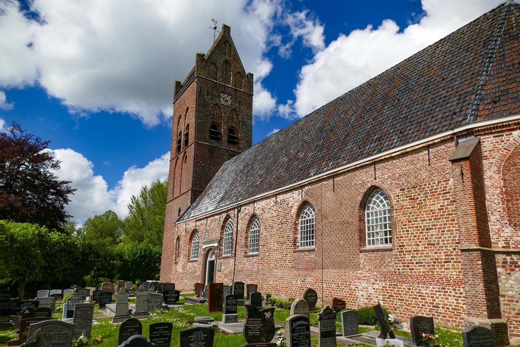
| Description | : | Originally a small church, built around 1100 in volcanic tuff stone in Romanesque style. In the 13th and 14th century it was considerably enlarged in Gothic style, using brick in various sizes, and provided with a pentagonal choir. Afterwards a few renovations in which, among other things, a wooden barrel vault was installed, the windows were reduced in size, buttresses were bricked and the gable roof tower was raised to 33 meters. This tower houses two bells, one from 1511 and one from 1949 and a 16th-century clockwork. In the church, under a glass Floor, there are 16th to 18th... Read More |
frequently asked questions (FAQ):
-
Where is Agnestsjerke?
Agnestsjerke is located at Buorren 23 Goutum, Leeuwarden Municipality ,Friesland , 9084 BBNetherlands.
-
Agnestsjerke cemetery's updated grave count on graveviews.com?
0 memorials
-
Where are the coordinates of the Agnestsjerke?
Latitude: 53.1786867
Longitude: 5.8068433
Nearby Cemetories:
1. Wirdum Protestant Churchyard
Wirdum, Leeuwarden Municipality, Netherlands
Coordinate: 53.1497300, 5.8036500
2. Joodse begraafplaats
Leeuwarden, Leeuwarden Municipality, Netherlands
Coordinate: 53.2089720, 5.7912400
3. Algemene Rooms-Katholieke Begraafplaats Vitushof
Leeuwarden, Leeuwarden Municipality, Netherlands
Coordinate: 53.2061700, 5.7694100
4. Kerkepad Begraafplaats
Wytgaard, Leeuwarden Municipality, Netherlands
Coordinate: 53.1418671, 5.7857350
5. Leeuwarden Noorderbegraafplaats
Leeuwarden, Leeuwarden Municipality, Netherlands
Coordinate: 53.2135900, 5.7733900
6. Lekkum Churchyard
Lekkum, Leeuwarden Municipality, Netherlands
Coordinate: 53.2263300, 5.8194900
7. Mariatsjerke
Beers, Littenseradiel Municipality, Netherlands
Coordinate: 53.1558525, 5.7329919
8. Sint-Pontianustsjerke
Marsum, Menaldumadeel Municipality, Netherlands
Coordinate: 53.2108700, 5.7280502
9. Wartena General Cemetery
Wartena, Leeuwarden Municipality, Netherlands
Coordinate: 53.1489700, 5.8919100
10. Kerkhof Hervormde Kerk Wartena
Wartena, Leeuwarden Municipality, Netherlands
Coordinate: 53.1495985, 5.8972222
11. Kerkhof Cornjum
Cornjum, Leeuwarderadeel Municipality, Netherlands
Coordinate: 53.2431266, 5.7825235
12. Redbadtsjerke churchyard
Jorwerd, Littenseradiel Municipality, Netherlands
Coordinate: 53.1457503, 5.7113044
13. Begraafplaats Sint-Vituskerk
Tytsjerk, Tytsjerksteradiel Municipality, Netherlands
Coordinate: 53.2062242, 5.9142663
14. Kerkhof Nederlands Hervormde Kerk
Suwâld, Tytsjerksteradiel Municipality, Netherlands
Coordinate: 53.1791922, 5.9273043
15. Sint-Vituskerk
Wyns, Tytsjerksteradiel Municipality, Netherlands
Coordinate: 53.2516880, 5.8322860
16. Giekerk Martinuskerk
Giekerk, Tytsjerksteradiel Municipality, Netherlands
Coordinate: 53.2411660, 5.8785276
17. Kerkhof Johanneskerk
Britsum, Leeuwarderadeel Municipality, Netherlands
Coordinate: 53.2542998, 5.7855996
18. Rijperkerk Nederlands Hervormd Kerkhof
Rijperkerk, Tytsjerksteradiel Municipality, Netherlands
Coordinate: 53.2221200, 5.9183300
19. Schillaard General Cemetery
Schillaard, Littenseradiel Municipality, Netherlands
Coordinate: 53.1237600, 5.7074600
20. Grouw Begraafplaats
Grou, Leeuwarden Municipality, Netherlands
Coordinate: 53.0943700, 5.8365700
21. Stiens Protestant Churchyard
Stiens, Leeuwarderadeel Municipality, Netherlands
Coordinate: 53.2624810, 5.7572899
22. Kerkhof
Baard, Littenseradiel Municipality, Netherlands
Coordinate: 53.1423432, 5.6684373
23. Marijetsjerke Begraafplaats
Oenkerk, Tytsjerksteradiel Municipality, Netherlands
Coordinate: 53.2537643, 5.8927362
24. Hoftsjerke begraafplaats
Hurdegaryp, Tytsjerksteradiel Municipality, Netherlands
Coordinate: 53.2175817, 5.9445193