
| Memorials | : | 0 |
| Location | : | Bisley, Stroud District, England |
| Website | : | www.bisleybenefice.org.uk/stmichaelandallangels.html |
| Coordinate | : | 51.7301150, -2.1715900 |
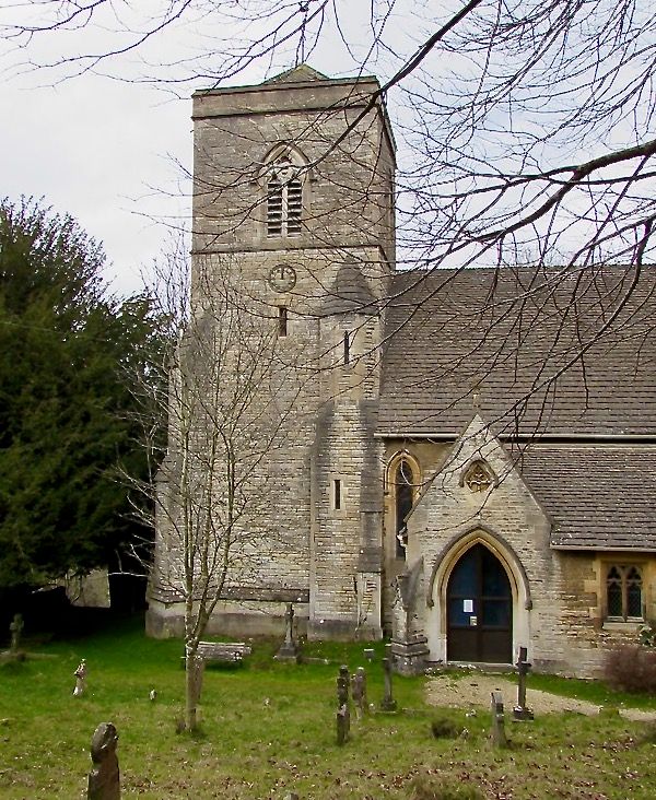
| Description | : | Founded by the Reverend Thomas Keble [1], and architected by James Parke Harrison, of Christ Church, Oxford. The church was consecrated by the Lord Bishop of Gloucester and Bristol on October 6. 1846. The land was given by a Miss Gordon, and around twenty students of different colleges at Oxford, were persuaded by the Reverend Thomas Keble to donate two thousand pounds to erect an edifice to the glory of God [2]. The Diocesan Church Building Society also gave a grant of one hundred and fifty pounds. It was consecrated as a Chapel of Ease to Bisley, for the use... Read More |
frequently asked questions (FAQ):
-
Where is St. Michael's and All Angels Churchyard?
St. Michael's and All Angels Churchyard is located at Bussage Hill, Bussage Bisley, Stroud District ,Gloucestershire , GL6 8BBEngland.
-
St. Michael's and All Angels Churchyard cemetery's updated grave count on graveviews.com?
0 memorials
-
Where are the coordinates of the St. Michael's and All Angels Churchyard?
Latitude: 51.7301150
Longitude: -2.1715900
Nearby Cemetories:
1. St. Mary of the Angels Churchyard
Chalford, Stroud District, England
Coordinate: 51.7219000, -2.1708000
2. Eastcombe Baptist Churchyard
Eastcombe, Stroud District, England
Coordinate: 51.7378009, -2.1606789
3. Christ Church Churchyard
Chalford, Stroud District, England
Coordinate: 51.7214500, -2.1577900
4. France Lynch Congregational Chapelyard
Chalford, Stroud District, England
Coordinate: 51.7251000, -2.1485300
5. St. John the Baptist Churchyard
France Lynch, Stroud District, England
Coordinate: 51.7265600, -2.1445600
6. Brimscombe Cemetery
Brimscombe, Stroud District, England
Coordinate: 51.7165900, -2.1900600
7. Chalford Baptist Tabernacle Churchyard
Chalford, Stroud District, England
Coordinate: 51.7226610, -2.1443260
8. Stroud Hill Cemetery
Stroud, Stroud District, England
Coordinate: 51.7415670, -2.2002660
9. Stroud Old Cemetery
Stroud, Stroud District, England
Coordinate: 51.7337658, -2.2094599
10. Holy Trinity Churchyard
Minchinhampton, Stroud District, England
Coordinate: 51.7063600, -2.1860700
11. St Bartholemew Church
Oakridge, Stroud District, England
Coordinate: 51.7291209, -2.1276180
12. Minchinhampton Baptist Churchyard
Minchinhampton, Stroud District, England
Coordinate: 51.7039614, -2.1853756
13. Bisley Burial Ground
Bisley, Stroud District, England
Coordinate: 51.7493640, -2.1389080
14. All Saints Churchyard
Bisley, Stroud District, England
Coordinate: 51.7520580, -2.1409380
15. St. Laurence Churchyard
Stroud, Stroud District, England
Coordinate: 51.7459470, -2.2153950
16. Rodborough Tabernacle
Rodborough, Stroud District, England
Coordinate: 51.7345300, -2.2245700
17. Amberley Methodist Church - Littleworth Wesleyan C
Amberley, Stroud District, England
Coordinate: 51.7123580, -2.2202540
18. Holy Trinity Churchyard
Amberley, Stroud District, England
Coordinate: 51.7087660, -2.2177170
19. Holy Trinity Churchyard
Slad, Stroud District, England
Coordinate: 51.7647770, -2.1866550
20. St. Mary Magdalene Churchyard
Rodborough, Stroud District, England
Coordinate: 51.7384180, -2.2284060
21. Amberley Church Cemetery
Amberley, Stroud District, England
Coordinate: 51.7091900, -2.2196100
22. St Mary's Churchyard
Woodchester, Stroud District, England
Coordinate: 51.7224900, -2.2333920
23. Priory Church of the Annunciation Churchyard
Woodchester, Stroud District, England
Coordinate: 51.7080680, -2.2305250
24. St Paul Churchyard
Whiteshill, Stroud District, England
Coordinate: 51.7597750, -2.2321540