
| Memorials | : | 10 |
| Location | : | Whiteshill, Stroud District, England |
| Coordinate | : | 51.7597750, -2.2321540 |
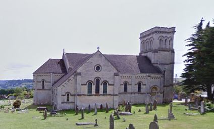
| Description | : | The church of St Paul is located south of the village of Whiteshill in Gloucestershire, east of ‘The Plain’ road. The church was built from 1839-41 by Thomas Foster of Bristol. Transepts were added in 1882. Whiteshill was created an ecclesiastical parish in 1844, from parts of the parishes of Stroud and Standish. It included the hamlets of Bread Street and Ruscombe, and a part of Pakenhill. A good-sized churchyard surrounds the church extending to the south with views over the open countryside to the east. |
frequently asked questions (FAQ):
-
Where is St Paul Churchyard?
St Paul Churchyard is located at Whiteshill, Stroud District ,Gloucestershire , GL6 6ABEngland.
-
St Paul Churchyard cemetery's updated grave count on graveviews.com?
10 memorials
-
Where are the coordinates of the St Paul Churchyard?
Latitude: 51.7597750
Longitude: -2.2321540
Nearby Cemetories:
1. St. John the Baptist Churchyard
Randwick, Stroud District, England
Coordinate: 51.7587400, -2.2514000
2. St John the Baptist Churchyard
Pitchcombe, Stroud District, England
Coordinate: 51.7727590, -2.2166790
3. St. Laurence Churchyard
Stroud, Stroud District, England
Coordinate: 51.7459470, -2.2153950
4. Saint Matthews Churchyard
Cainscross, Stroud District, England
Coordinate: 51.7430640, -2.2469780
5. St. Mary Magdalene Churchyard
Rodborough, Stroud District, England
Coordinate: 51.7384180, -2.2284060
6. Rodborough Tabernacle
Rodborough, Stroud District, England
Coordinate: 51.7345300, -2.2245700
7. Stroud Hill Cemetery
Stroud, Stroud District, England
Coordinate: 51.7415670, -2.2002660
8. Holy Trinity Churchyard
Slad, Stroud District, England
Coordinate: 51.7647770, -2.1866550
9. All Saints Churchyard
Selsley, Stroud District, England
Coordinate: 51.7327800, -2.2487900
10. Stroud Old Cemetery
Stroud, Stroud District, England
Coordinate: 51.7337658, -2.2094599
11. St John the Baptist Churchyard
Harescombe, Stroud District, England
Coordinate: 51.7921570, -2.2373260
12. St. Mary the Virgin Churchyard
Painswick, Stroud District, England
Coordinate: 51.7852975, -2.1947224
13. St George's Churchyard
Kings Stanley, Stroud District, England
Coordinate: 51.7352650, -2.2765210
14. St Mary's Churchyard
Woodchester, Stroud District, England
Coordinate: 51.7224900, -2.2333920
15. Kings Stanley Baptist Cemetery
Kings Stanley, Stroud District, England
Coordinate: 51.7269460, -2.2621780
16. St. Cyr Churchyard
Stonehouse, Stroud District, England
Coordinate: 51.7433750, -2.2917980
17. St. Peter's Churchyard
Haresfield, Stroud District, England
Coordinate: 51.7921323, -2.2767870
18. Painswick Cemetery
Painswick, Stroud District, England
Coordinate: 51.7971040, -2.1918690
19. St. Michael's and All Angels Churchyard
Bisley, Stroud District, England
Coordinate: 51.7301150, -2.1715900
20. Amberley Methodist Church - Littleworth Wesleyan C
Amberley, Stroud District, England
Coordinate: 51.7123580, -2.2202540
21. St. Swithun Churchyard
Brookthorpe, Stroud District, England
Coordinate: 51.8087500, -2.2402900
22. Eastcombe Baptist Churchyard
Eastcombe, Stroud District, England
Coordinate: 51.7378009, -2.1606789
23. Brimscombe Cemetery
Brimscombe, Stroud District, England
Coordinate: 51.7165900, -2.1900600
24. Amberley Church Cemetery
Amberley, Stroud District, England
Coordinate: 51.7091900, -2.2196100