
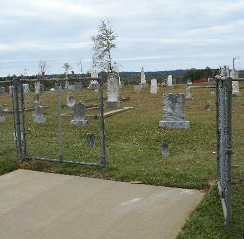
| Memorials | : | 0 |
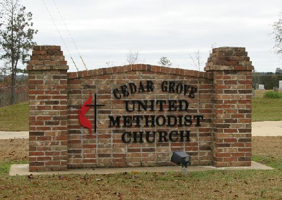
| Location | : | Raleigh, Smith County, USA |
| Coordinate | : | 32.0664100, -89.4145800 |
| Description | : | From Raleigh, Mississippi proceed East on Highway 18, also called Sylvarena Ave for approxiamtely 7.5 miles to the intersection of Highway 501. Turn left (North) onto Hwy 501 and proceed approximately 4 miles, the Cedar Grove Methodist cemetery will be on the left (North) side of Hwy 501, specifically: NW1/4 SE1/4, S30, T3N-R9E, Smith, Louin SW Quadrangle map, USNG: 16S BA 72065 50339. |
frequently asked questions (FAQ):
-
Where is Cedar Grove Methodist Church Cemetery?
Cedar Grove Methodist Church Cemetery is located at 3983 Mississippi Highway 501 Raleigh, Smith County ,Mississippi , 39153USA.
-
Cedar Grove Methodist Church Cemetery cemetery's updated grave count on graveviews.com?
0 memorials
-
Where are the coordinates of the Cedar Grove Methodist Church Cemetery?
Latitude: 32.0664100
Longitude: -89.4145800
Nearby Cemetories:
1. Jesus Name Church Cemetery
Raleigh, Smith County, USA
Coordinate: 32.0610700, -89.3933700
2. Royals & Webb Cemetery
Raleigh, Smith County, USA
Coordinate: 32.0932999, -89.4096985
3. William F. Jones Cemetery
Raleigh, Smith County, USA
Coordinate: 32.0672200, -89.3739800
4. Mount Nebo Baptist Cemetery
Raleigh, Smith County, USA
Coordinate: 32.0981000, -89.4317400
5. Double Church Cemetery
Raleigh, Smith County, USA
Coordinate: 32.0460420, -89.4574910
6. First Sylverena Seventh Day Adventist Cemetery
Raleigh, Smith County, USA
Coordinate: 32.0514600, -89.3686560
7. Russell - Boykin Cemetery
Smith County, USA
Coordinate: 32.1066472, -89.3997402
8. Hopewell Missionary Baptist Church Cemetery
Raleigh, Smith County, USA
Coordinate: 32.0474900, -89.3696600
9. Mount Pleasant Baptist Church Cemetery
Raleigh, Smith County, USA
Coordinate: 32.0228859, -89.4116950
10. Warren Hill Methodist Church Cemetery
Sylvarena, Smith County, USA
Coordinate: 32.0672300, -89.3595300
11. Healing Springs Community Cemetery
Smith County, USA
Coordinate: 32.0685100, -89.3594810
12. Hills Chapel Cemetery
Jasper County, USA
Coordinate: 32.0668500, -89.3577230
13. Bethany Cemetery
Sylvarena, Smith County, USA
Coordinate: 32.0280991, -89.3743973
14. Johnson Cemetery
Raleigh, Smith County, USA
Coordinate: 32.0146900, -89.4217500
15. Mount Nebo Cemetery
Smith County, USA
Coordinate: 32.0951900, -89.4677200
16. Jesus Name House of Prayer Cemetery
Raleigh, Smith County, USA
Coordinate: 32.0116790, -89.4280510
17. High Hill Baptist Church Cemetery
Raleigh, Smith County, USA
Coordinate: 32.0860100, -89.4780800
18. Sylvan Grove Cemetery
Smith County, USA
Coordinate: 32.1137310, -89.4530439
19. Trinity Methodist Cemetery
Raleigh, Smith County, USA
Coordinate: 32.0920600, -89.4753300
20. Hartley Cemetery
Raleigh, Smith County, USA
Coordinate: 32.0087250, -89.4264670
21. Sylvarena Cemetery
Sylvarena, Smith County, USA
Coordinate: 32.0137200, -89.3793800
22. Pineville-Leaf River Cemetery
Smith County, USA
Coordinate: 32.1266000, -89.3987200
23. Moore Cemetery
Raleigh, Smith County, USA
Coordinate: 32.0132190, -89.4658840
24. Bibleway Crusade Cemetery
Smith County, USA
Coordinate: 32.0829940, -89.3322550