
| Memorials | : | 0 |
| Location | : | Newport, Campbell County, USA |
| Coordinate | : | 39.0885220, -84.4754710 |
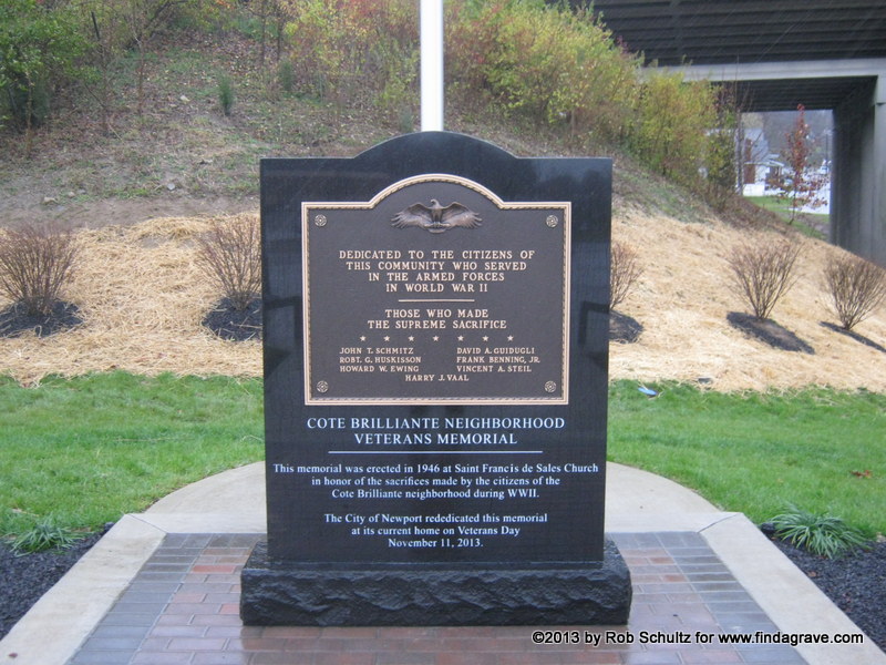
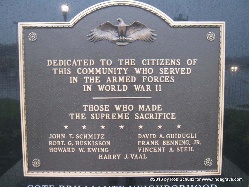
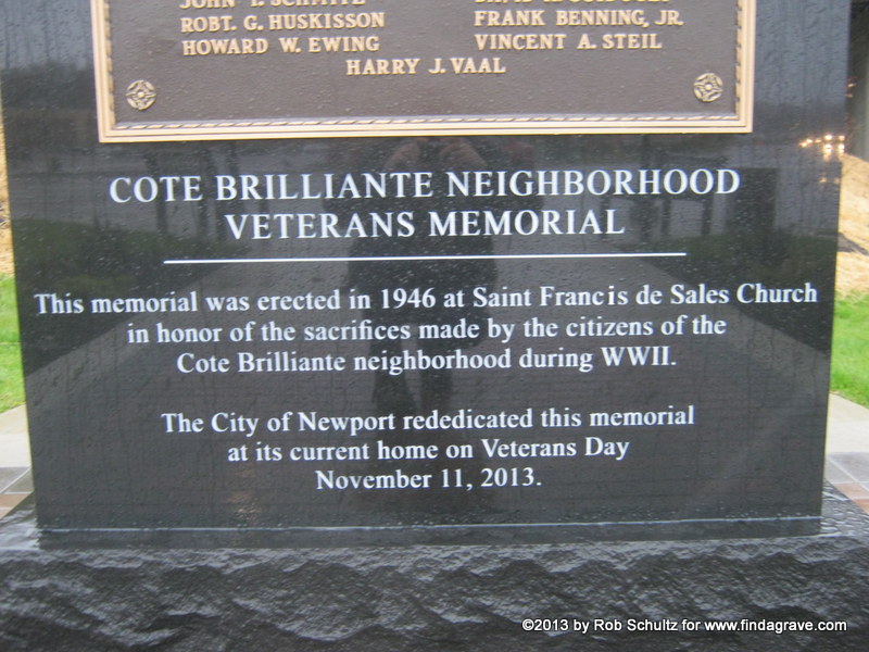
| Description | : | The Cote Brilliante World War II Memorial was dedicated in 1946 to veterans from the Newport, Kentucky neighborhood of Cote Brilliante. When most of the neighborhood was demolished in a very unethical use of eminent domain to make way for a shopping center, an elderly man removed the memorial from its masonry foundation to ensure its safety. It was presented to the City of Newport by the man's son after his death; it was then refurbished and rededicated on Veterans Day, November 11, 2013. The bronze plaque lists seven American Soldiers, Sailors, Airmen and Marines who gave their lives for their... Read More |
frequently asked questions (FAQ):
-
Where is Cote Brilliante World War II Memorial?
Cote Brilliante World War II Memorial is located at Pavilion Parkway and Chesapeake Avenue Newport, Campbell County ,Kentucky , 41071USA.
-
Cote Brilliante World War II Memorial cemetery's updated grave count on graveviews.com?
0 memorials
-
Where are the coordinates of the Cote Brilliante World War II Memorial?
Latitude: 39.0885220
Longitude: -84.4754710
Nearby Cemetories:
1. Mount Saint Martins Cemetery (Defunct)
Newport, Campbell County, USA
Coordinate: 39.0860570, -84.4845320
2. Old Newport Cemetery
Newport, Campbell County, USA
Coordinate: 39.0877100, -84.4940800
3. Madison Street Burying Ground
Newport, Campbell County, USA
Coordinate: 39.0922790, -84.4948560
4. Evergreen Cemetery
Southgate, Campbell County, USA
Coordinate: 39.0667000, -84.4721985
5. McCrackin Gravesite
Cincinnati, Hamilton County, USA
Coordinate: 39.0964090, -84.5082230
6. Trinity Episcopal Church Memorial Garden
Covington, Kenton County, USA
Coordinate: 39.0873540, -84.5106140
7. Cathedral Basilica of the Assumption
Covington, Kenton County, USA
Coordinate: 39.0781120, -84.5081700
8. Christ Church Cathedral Columbarium
Cincinnati, Hamilton County, USA
Coordinate: 39.1009690, -84.5073790
9. Saint Francis of Assisi Roman Catholic Cemetery
Dayton, Campbell County, USA
Coordinate: 39.1115840, -84.4545220
10. Wesleyan Chapel Methodist Church Cemetery
Cincinnati, Hamilton County, USA
Coordinate: 39.1022390, -84.5073540
11. Mother of God Church
Covington, Kenton County, USA
Coordinate: 39.0839600, -84.5125700
12. First Presbyterian Church Cemetery
Cincinnati, Hamilton County, USA
Coordinate: 39.1005310, -84.5102830
13. Craig Street Burying Ground
Covington, Kenton County, USA
Coordinate: 39.0840890, -84.5151330
14. Linden Grove Cemetery
Covington, Kenton County, USA
Coordinate: 39.0738983, -84.5152969
15. Thomas Williams Cemetery (Defunct)
Cincinnati, Hamilton County, USA
Coordinate: 39.1085060, -84.5146050
16. Buena Vista Cemetery
Covington, Kenton County, USA
Coordinate: 39.0595200, -84.5040000
17. First Quaker Cemetery (Defunct)
Cincinnati, Hamilton County, USA
Coordinate: 39.1004360, -84.5201220
18. Fulton Cemetery #2
Columbia, Hamilton County, USA
Coordinate: 39.1067543, -84.4332809
19. Fulton-Presbyterian Cemetery
Fulton, Hamilton County, USA
Coordinate: 39.1074982, -84.4332962
20. Presbyterian Burying Ground
Cincinnati, Hamilton County, USA
Coordinate: 39.1082510, -84.5175720
21. Christ Episcopal Churchyard (Defunct)
Cincinnati, Hamilton County, USA
Coordinate: 39.1100520, -84.5177220
22. Christ Church Cemetery
Over-The-Rhine, Hamilton County, USA
Coordinate: 39.1126480, -84.5157623
23. Potters Field
Cincinnati, Hamilton County, USA
Coordinate: 39.1094440, -84.5188890
24. Chestnut Street Cemetery
Over-The-Rhine, Hamilton County, USA
Coordinate: 39.1071610, -84.5212210