
| Memorials | : | 1 |
| Location | : | Cincinnati, Hamilton County, USA |
| Coordinate | : | 39.1094440, -84.5188890 |
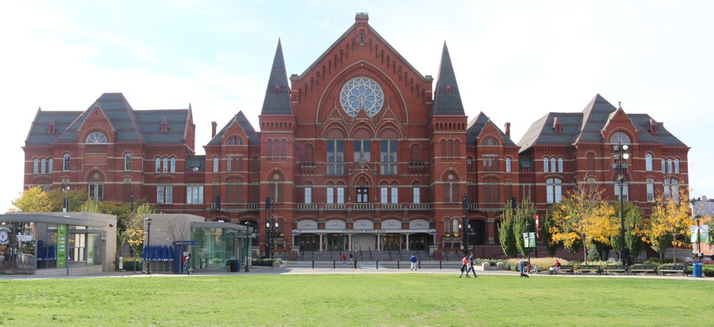
| Description | : | A Public Burying Ground, or Potters Field, was located in Lot 53 of the city of Cincinnati, as shown on the map titled “Plan of Cincinnati, Including All the late Additions & Subdivisions, Engraved for Oliver Farnsworth 1819”. The cemetery was established about 1810 with its last burial about 1852. The former location of the cemetery is now the site of Cincinnati Music Hall. According to 1913 account {"Social Problems pamphlets"}p.17: "In Cincinnati the practise is equally involved, and out of 305 pauper burials 76 were under the supervision of the Department of Public Welfare, 34 were deaths which... Read More |
frequently asked questions (FAQ):
-
Where is Potters Field?
Potters Field is located at Elm Street and W. 14th Street Cincinnati, Hamilton County ,Ohio , 45202USA.
-
Potters Field cemetery's updated grave count on graveviews.com?
1 memorials
-
Where are the coordinates of the Potters Field?
Latitude: 39.1094440
Longitude: -84.5188890
Nearby Cemetories:
1. Christ Episcopal Churchyard (Defunct)
Cincinnati, Hamilton County, USA
Coordinate: 39.1100520, -84.5177220
2. Presbyterian Burying Ground
Cincinnati, Hamilton County, USA
Coordinate: 39.1082510, -84.5175720
3. Chestnut Street Cemetery
Over-The-Rhine, Hamilton County, USA
Coordinate: 39.1071610, -84.5212210
4. Thomas Williams Cemetery (Defunct)
Cincinnati, Hamilton County, USA
Coordinate: 39.1085060, -84.5146050
5. Christ Church Cemetery
Over-The-Rhine, Hamilton County, USA
Coordinate: 39.1126480, -84.5157623
6. Enon Baptist Church Burying Ground (Defunct)
Cincinnati, Hamilton County, USA
Coordinate: 39.1065420, -84.5238110
7. Catherine Street Methodist Cemetery (Defunct)
Cincinnati, Hamilton County, USA
Coordinate: 39.1064840, -84.5243150
8. Catherine Street Burying Ground
Cincinnati, Hamilton County, USA
Coordinate: 39.1067490, -84.5252700
9. First Quaker Cemetery (Defunct)
Cincinnati, Hamilton County, USA
Coordinate: 39.1004360, -84.5201220
10. Second Quaker Cemetery (Defunct)
Cincinnati, Hamilton County, USA
Coordinate: 39.1153090, -84.5305240
11. First Presbyterian Church Cemetery
Cincinnati, Hamilton County, USA
Coordinate: 39.1005310, -84.5102830
12. Wesleyan Chapel Methodist Church Cemetery
Cincinnati, Hamilton County, USA
Coordinate: 39.1022390, -84.5073540
13. Lincoln Park Potters Field (Defunct)
Cincinnati, Hamilton County, USA
Coordinate: 39.1097710, -84.5346450
14. Christ Church Cathedral Columbarium
Cincinnati, Hamilton County, USA
Coordinate: 39.1009690, -84.5073790
15. McCrackin Gravesite
Cincinnati, Hamilton County, USA
Coordinate: 39.0964090, -84.5082230
16. Trinity Episcopal Church Memorial Garden
Covington, Kenton County, USA
Coordinate: 39.0873540, -84.5106140
17. Madison Street Burying Ground
Newport, Campbell County, USA
Coordinate: 39.0922790, -84.4948560
18. Craig Street Burying Ground
Covington, Kenton County, USA
Coordinate: 39.0840890, -84.5151330
19. Mother of God Church
Covington, Kenton County, USA
Coordinate: 39.0839600, -84.5125700
20. Methodist Protestant Cemetery (Defunct)
Cincinnati, Hamilton County, USA
Coordinate: 39.1324770, -84.4983160
21. Old Newport Cemetery
Newport, Campbell County, USA
Coordinate: 39.0877100, -84.4940800
22. Hillside Chapel Crematory and Columbarium
Cincinnati, Hamilton County, USA
Coordinate: 39.1393509, -84.5247192
23. Cathedral Basilica of the Assumption
Covington, Kenton County, USA
Coordinate: 39.0781120, -84.5081700
24. Montague Cemetery
Covington, Kenton County, USA
Coordinate: 39.0805560, -84.5380550