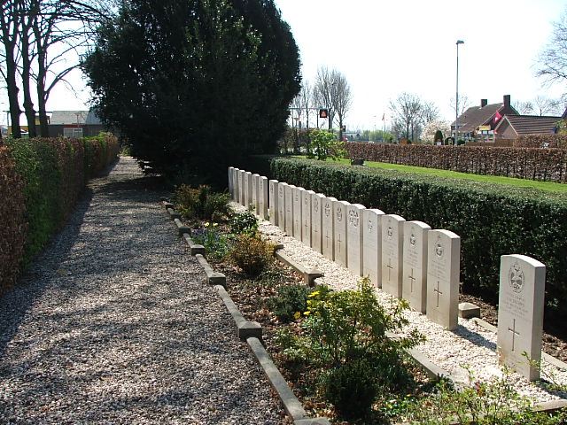
| Memorials | : | 0 |
| Location | : | Heteren, Overbetuwe Municipality, Netherlands |
| Coordinate | : | 51.9530900, 5.7574100 |
| Description | : | Heteren is a small village 12 kilometres south-west of Arnhem, on the south bank of the Neder (Lower) Rhine. The cemetery is 800 metres south of the village in Achterstraat, by the roundabout with the junctions of Flessestraat and Polderstraat. |
frequently asked questions (FAQ):
-
Where is Heteren General Cemetery?
Heteren General Cemetery is located at Heteren, Overbetuwe Municipality ,Gelderland ,Netherlands.
-
Heteren General Cemetery cemetery's updated grave count on graveviews.com?
0 memorials
-
Where are the coordinates of the Heteren General Cemetery?
Latitude: 51.9530900
Longitude: 5.7574100
Nearby Cemetories:
1. Renkum Roman Catholic Cemetery
Renkum, Renkum Municipality, Netherlands
Coordinate: 51.9752800, 5.7375200
2. Onder de Bomen Cemetery
Renkum, Renkum Municipality, Netherlands
Coordinate: 51.9714500, 5.7205500
3. Begraafplaats Vluchtheuvelkerk Protestant
Zetten, Overbetuwe Municipality, Netherlands
Coordinate: 51.9315860, 5.7141320
4. Driel Protestant Churchyard
Driel, Overbetuwe Municipality, Netherlands
Coordinate: 51.9619700, 5.8113700
5. Doorwerth Roman Catholic Cemetery
Doorwerth, Renkum Municipality, Netherlands
Coordinate: 51.9783200, 5.8058900
6. Andelst Kerkhof
Andelst, Overbetuwe Municipality, Netherlands
Coordinate: 51.9057800, 5.7278200
7. Joodse Begraafplaats
Wageningen Municipality, Netherlands
Coordinate: 51.9668606, 5.6695901
8. Begraafplaats de Leeuwerenk
Wageningen, Wageningen Municipality, Netherlands
Coordinate: 51.9849600, 5.6806900
9. Oude Algemene Begraafplaats
Oosterbeek, Renkum Municipality, Netherlands
Coordinate: 51.9832100, 5.8434700
10. Bennekom Algemene Begraafplaats
Bennekom, Ede Municipality, Netherlands
Coordinate: 51.9983500, 5.6775500
11. Oosterbeek General Cemetery
Oosterbeek, Renkum Municipality, Netherlands
Coordinate: 51.9920100, 5.8490100
12. Arnhem War Cemetery
Oosterbeek, Renkum Municipality, Netherlands
Coordinate: 51.9931800, 5.8481900
13. Slijk-Ewijk General Cemetery
Slijk-Ewijk, Overbetuwe Municipality, Netherlands
Coordinate: 51.8839100, 5.7854400
14. Dodewaard General Cemetery
Dodewaard, Neder-Betuwe Municipality, Netherlands
Coordinate: 51.9103800, 5.6538200
15. Opheusden General Cemetery
Opheusden, Neder-Betuwe Municipality, Netherlands
Coordinate: 51.9322600, 5.6339800
16. Haaghove
Beuningen, Beuningen Municipality, Netherlands
Coordinate: 51.8666649, 5.7850499
17. Joodse Begraafplaats Utrechtseweg
Arnhem, Arnhem Municipality, Netherlands
Coordinate: 51.9853100, 5.8906500
18. Natuurbegraafplaats Heidepol
Arnhem, Arnhem Municipality, Netherlands
Coordinate: 52.0333784, 5.8232974
19. Militair Ereveld Grebbeberg
Rhenen, Rhenen Municipality, Netherlands
Coordinate: 51.9556300, 5.6004200
20. Paasberg Mausoleum
Ede, Ede Municipality, Netherlands
Coordinate: 52.0437800, 5.6786500
21. Voormalige Begraafplaats Onder de Linden
Arnhem, Arnhem Municipality, Netherlands
Coordinate: 51.9889652, 5.9166571
22. Schaarsbergen Vredenoord Cemetery
Schaarsbergen, Arnhem Municipality, Netherlands
Coordinate: 52.0290600, 5.8745300
23. Arnhem Moscowa General Cemetery
Arnhem, Arnhem Municipality, Netherlands
Coordinate: 52.0050800, 5.9152800
24. Joodse Begraafplaats Moscowa
Arnhem, Arnhem Municipality, Netherlands
Coordinate: 52.0022860, 5.9203300


