
| Memorials | : | 136 |
| Location | : | Kings Sutton, South Northamptonshire Borough, England |
| Coordinate | : | 52.0212000, -1.2763560 |
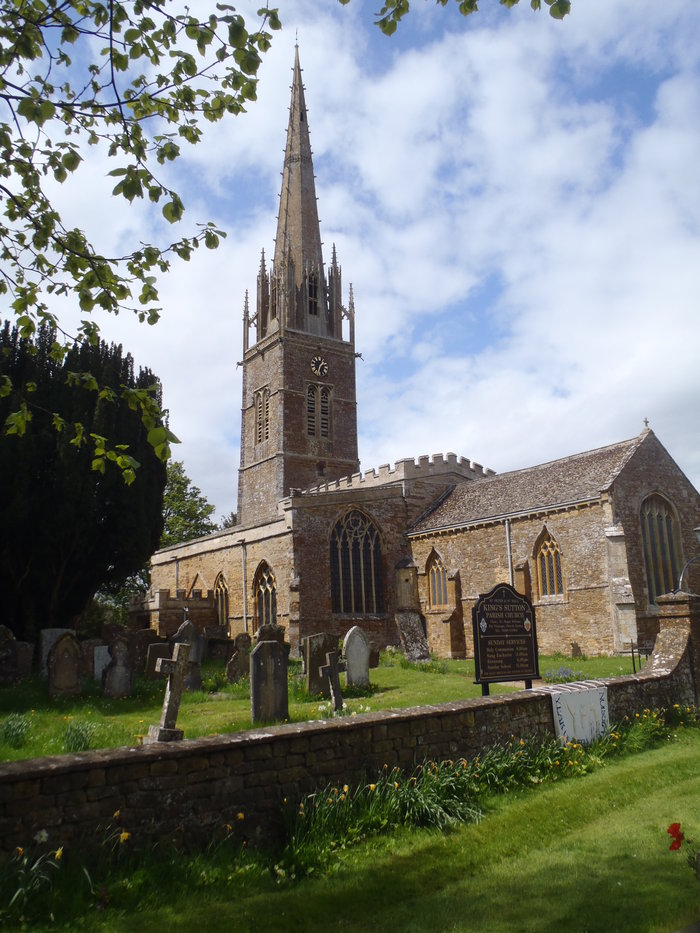
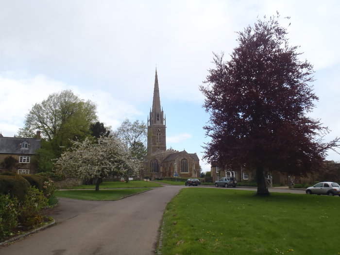
| Description | : | King's Sutton is a village and civil parish in South Northamptonshire, England in the valley of the River Cherwell. The village is about 4 miles (6.4 km) south-east of Banbury, Oxfordshire. The oldest parts of the Church of England parish church of Saints Peter and Paul are the Norman font and largely Norman chancel. The north aisle was added in the 13th century and the south aisle early in the 14th century. The bell tower and most of the windows are Decorated Gothic. The spire was added to the tower probably late in the 14th century, raising the steeple to a... Read More |
frequently asked questions (FAQ):
-
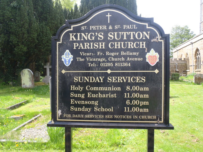
Where is Ss Peter and Paul Churchyard?
Ss Peter and Paul Churchyard is located at Red Lion Street Kings Sutton, South Northamptonshire Borough ,Northamptonshire , OX17 3RJEngland.
-
Ss Peter and Paul Churchyard cemetery's updated grave count on graveviews.com?
136 memorials
-
Where are the coordinates of the Ss Peter and Paul Churchyard?
Latitude: 52.0212000
Longitude: -1.2763560
Nearby Cemetories:
1. Kings Sutton Cemetery
Kings Sutton, South Northamptonshire Borough, England
Coordinate: 52.0151400, -1.2711000
2. Saint James' Churchyard
Newbottle, South Northamptonshire Borough, England
Coordinate: 52.0280500, -1.2382170
3. St Mary the Virgin Churchyard
Adderbury, Cherwell District, England
Coordinate: 52.0148420, -1.3152270
4. Newbottle and Charlton Cemetery
Newbottle, South Northamptonshire Borough, England
Coordinate: 52.0225300, -1.2351200
5. Adderbury Parish Cemetery
Adderbury, Cherwell District, England
Coordinate: 52.0139537, -1.3246874
6. St Michael Churchyard
Aynho, South Northamptonshire Borough, England
Coordinate: 51.9936080, -1.2522380
7. Saint John the Baptist Churchyard
Bodicote, Cherwell District, England
Coordinate: 52.0356100, -1.3305700
8. St Mary Church
Warkworth, South Northamptonshire Borough, England
Coordinate: 52.0627000, -1.2917000
9. Bodicote Cemetery
Bodicote, Cherwell District, England
Coordinate: 52.0391710, -1.3397380
10. St John the Evangelist
Milton, Cherwell District, England
Coordinate: 52.0117900, -1.3452510
11. St Mary the Virgin Churchyard
Souldern, Cherwell District, England
Coordinate: 51.9808600, -1.2399900
12. Ss Peter and Paul Churchyard
Deddington, Cherwell District, England
Coordinate: 51.9817680, -1.3207470
13. All Saints Churchyard
Croughton, South Northamptonshire Borough, England
Coordinate: 51.9977370, -1.2065760
14. Croughton Cemetery
Croughton, South Northamptonshire Borough, England
Coordinate: 52.0014880, -1.2031960
15. St Mary the Virgin Churchyard
Thenford, South Northamptonshire Borough, England
Coordinate: 52.0697510, -1.2442930
16. Deddington Cemetery
Deddington, Cherwell District, England
Coordinate: 51.9824490, -1.3338930
17. All Saints Churchyard
Middleton Cheney, South Northamptonshire Borough, England
Coordinate: 52.0741984, -1.2740247
18. Middleton Cheney Cemetery
Middleton Cheney, South Northamptonshire Borough, England
Coordinate: 52.0745100, -1.2692900
19. Holy Trinity Church
Hinton-in-the-Hedges, South Northamptonshire Borough, England
Coordinate: 52.0281190, -1.1881330
20. St. John the Evangelist Churchyard
Banbury, Cherwell District, England
Coordinate: 52.0598790, -1.3400100
21. St. Mary the Virgin Churchyard
Banbury, Cherwell District, England
Coordinate: 52.0614620, -1.3391870
22. St John's Churchyard
Barford St John, Cherwell District, England
Coordinate: 51.9955050, -1.3620350
23. St Mary's Churchyard
Bloxham, Cherwell District, England
Coordinate: 52.0181100, -1.3748900
24. Southam Road Cemetery
Banbury, Cherwell District, England
Coordinate: 52.0679120, -1.3405760