
| Memorials | : | 0 |
| Location | : | Aalten, Aalten Municipality, Netherlands |
| Coordinate | : | 51.9252900, 6.5988300 |
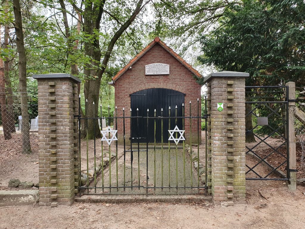
| Description | : | The cemetery, which was laid out in a forest on the Haartsestraat, officially became the property of the Jewish community in 1852. Burials may have taken place from 1820 onwards. During the war years the cemetery was destroyed but was later restored. |
frequently asked questions (FAQ):
-
Where is Joodse Begraafplaats?
Joodse Begraafplaats is located at Haartsestraat 150 Aalten, Aalten Municipality ,Gelderland , 2171 WKNetherlands.
-
Joodse Begraafplaats cemetery's updated grave count on graveviews.com?
0 memorials
-
Where are the coordinates of the Joodse Begraafplaats?
Latitude: 51.9252900
Longitude: 6.5988300
Nearby Cemetories:
1. Grafheuvel Nannielaantje
Aalten, Aalten Municipality, Netherlands
Coordinate: 51.9285000, 6.5957200
2. Aalten Rooms-Katholieke Begraafplaats
Aalten, Aalten Municipality, Netherlands
Coordinate: 51.9218500, 6.5784000
3. Oude Begraafplaats
Aalten, Aalten Municipality, Netherlands
Coordinate: 51.9283288, 6.5776327
4. Berkenhove General Cemetery
Aalten, Aalten Municipality, Netherlands
Coordinate: 51.9342100, 6.5758700
5. Joodse Begraafplaats
Bredevoort, Aalten Municipality, Netherlands
Coordinate: 51.9408108, 6.6189064
6. Oude Begraafplaats
Bredevoort, Aalten Municipality, Netherlands
Coordinate: 51.9409683, 6.6195741
7. Kloosterhof
Bredevoort, Aalten Municipality, Netherlands
Coordinate: 51.9461994, 6.6127766
8. Lichtenvoorde General Cemetery
Lichtenvoorde, Oost Gelre Municipality, Netherlands
Coordinate: 51.9886300, 6.5968600
9. Joodse Begraafplaats Misterweg
Winterswijk Municipality, Netherlands
Coordinate: 51.9673710, 6.7024360
10. Nieuwe Begraafplaats
Dinxperlo, Aalten Municipality, Netherlands
Coordinate: 51.8688335, 6.4971512
11. Joodse Begraafplaats Spoorstraat
Winterswijk Municipality, Netherlands
Coordinate: 51.9685800, 6.7173600
12. Varsseveld General Cemetery
Varsseveld, Oude Ijsselstreek Municipality, Netherlands
Coordinate: 51.9402100, 6.4632300
13. Dinxperlo General Cemetery
Dinxperlo, Aalten Municipality, Netherlands
Coordinate: 51.8636700, 6.4893000
14. Winterswijk General Cemetery
Winterswijk, Winterswijk Municipality, Netherlands
Coordinate: 51.9795500, 6.7254100
15. Joodse Begraafplaats
Dinxperlo, Aalten Municipality, Netherlands
Coordinate: 51.8587400, 6.4797200
16. Groenlo Roman Catholic Cemetery
Groenlo, Oost Gelre Municipality, Netherlands
Coordinate: 52.0350700, 6.6137700
17. Joodse Begraafsplaats
Groenlo, Oost Gelre Municipality, Netherlands
Coordinate: 52.0448890, 6.6163030
18. Nieuwe Hervormde Begraafplaats
Groenlo, Oost Gelre Municipality, Netherlands
Coordinate: 52.0455970, 6.6166189
19. Halle Protestant Cemetery
Halle, Bronckhorst Municipality, Netherlands
Coordinate: 51.9921000, 6.4249400
20. Joodse Begraafsplaats Oude Ijsselstreek
Gendringen, Oude Ijsselstreek Municipality, Netherlands
Coordinate: 51.8782250, 6.3860750
21. Joodse Begraafplaats
Terborg, Oude Ijsselstreek Municipality, Netherlands
Coordinate: 51.9177220, 6.3725280
22. Gendringen Roman Catholic Cemetery
Gendringen, Oude Ijsselstreek Municipality, Netherlands
Coordinate: 51.8741900, 6.3785500
23. Hervormde Begraafplaats
Gendringen, Oude Ijsselstreek Municipality, Netherlands
Coordinate: 51.8710900, 6.3661700
24. Begraafplaats Kommendijk
Doetinchem Municipality, Netherlands
Coordinate: 51.9640325, 6.3423601