
| Memorials | : | 1 |
| Location | : | Last Chance, Placer County, USA |
| Coordinate | : | 39.1111900, -120.6254100 |
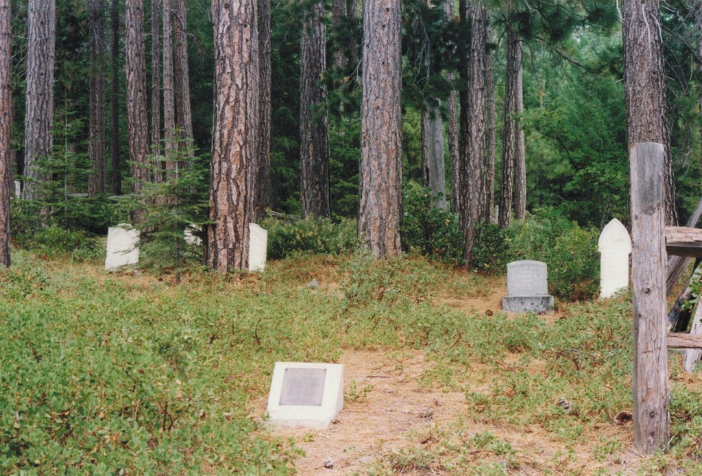
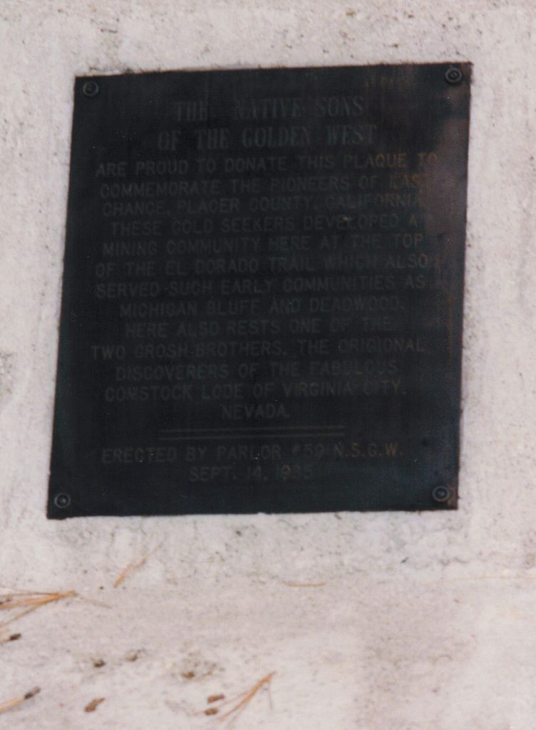
| Description | : | Last Chance is a mining district south of the main branch of the North Fork of the American River; north-east of Michigan Bluff. The diggins were discovered in 1850 and established October 13th 1856. In 1871 local newspapers reported rich profits by hydraulic mining. In 1927 the total production of the district was $2,500,000. mainly from the El Dorado Mine, which continues to be workd intermittently. The camp at Last Chance was called Caroline Diggins. The Last Chance mine was run by hydraulic method in a small way in the early 1970.s. Following plaque was erected by Parlor #59... Read More |
frequently asked questions (FAQ):
-
Where is Last Chance Cemetery?
Last Chance Cemetery is located at Last Chance, Placer County ,California ,USA.
-
Last Chance Cemetery cemetery's updated grave count on graveviews.com?
1 memorials
-
Where are the coordinates of the Last Chance Cemetery?
Latitude: 39.1111900
Longitude: -120.6254100
Nearby Cemetories:
1. Odd Fellows Cemetery
Michigan Bluff, Placer County, USA
Coordinate: 39.0449240, -120.7361840
2. Deadwood Cemetery
Foresthill, Placer County, USA
Coordinate: 39.0447700, -120.7361200
3. Michigan Bluff Cemetery
Placer County, USA
Coordinate: 39.0409400, -120.7401200
4. Stoney Bar Cemetery
Foresthill, Placer County, USA
Coordinate: 39.0114980, -120.7408060
5. Saint Joseph Catholic Cemetery
Foresthill, Placer County, USA
Coordinate: 39.0240200, -120.8068800
6. Foresthill Community Cemetery
Foresthill, Placer County, USA
Coordinate: 39.0184500, -120.8114700
7. Saint Dominics Catholic Cemetery
Iowa Hill, Placer County, USA
Coordinate: 39.1108880, -120.8568740
8. Iowa Hill Chinese Cemetery
Iowa Hill, Placer County, USA
Coordinate: 39.1113090, -120.8573260
9. Old Iowa Hill Cemetery
Iowa Hill, Placer County, USA
Coordinate: 39.1116667, -120.8575000
10. Josephine Mine Cemetery
Volcanoville, El Dorado County, USA
Coordinate: 38.9798000, -120.7892170
11. Dutch Flat Cemetery
Dutch Flat, Placer County, USA
Coordinate: 39.2055000, -120.8340500
12. Gold Run Cemetery
Placer County, USA
Coordinate: 39.1757100, -120.8612900
13. Yankee Jims Cemetery
Foresthill, Placer County, USA
Coordinate: 39.0292511, -120.8614349
14. Todd Valley Cemetery
Placer County, USA
Coordinate: 38.9970900, -120.8541000
15. You Bet Cemetery
Nevada County, USA
Coordinate: 39.2036050, -120.9054320
16. Carmelite Monastery Cemetery
Georgetown, El Dorado County, USA
Coordinate: 38.9273300, -120.8173840
17. Omega Cemetery
Omega, Nevada County, USA
Coordinate: 39.3310100, -120.7498500
18. Spring Garden Indian Cemetery
Foresthill, Placer County, USA
Coordinate: 38.9998620, -120.9049310
19. Red Dog Cemetery
Grass Valley, Nevada County, USA
Coordinate: 39.2173340, -120.9094920
20. Colfax Cemetery
Colfax, Placer County, USA
Coordinate: 39.0979522, -120.9471644
21. Georgia Slide Cemetery
Georgetown, El Dorado County, USA
Coordinate: 38.9218063, -120.8377838
22. Colfax Indian Cemetery
Colfax, Placer County, USA
Coordinate: 39.0909900, -120.9503000
23. Georgetown Pioneer Cemetery
Georgetown, El Dorado County, USA
Coordinate: 38.9068108, -120.8430862
24. Saint Paul Lutheran Cemetery
Pinecrest, Nevada County, USA
Coordinate: 39.1475900, -120.9649400