
| Memorials | : | 0 |
| Location | : | Mayfield, Wealden District, England |
| Coordinate | : | 51.0212245, 0.2614751 |
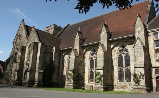
| Description | : | History of the Mayfield School This school may be unique in owing its existence to a picnic. On May 26 1863 Mother Cornelia Connelly, who had founded the Society of the Holy Child Jesus in 1846, escorted a small group of girls from the Holy Child school at St Leonards-on-Sea to the ruins of the Old Palace of Mayfield, where they would enjoy a picnic. The peace of the countryside and the elegance of the ruins must have left their mark on Cornelia, for within a matter of weeks the estate had been purchased by the Duchess of Leeds and presented... Read More |
frequently asked questions (FAQ):
-
Where is Mayfield School Chapel?
Mayfield School Chapel is located at The Old Palace, High Street Mayfield, Wealden District ,East Sussex , TN20 6PHEngland.
-
Mayfield School Chapel cemetery's updated grave count on graveviews.com?
0 memorials
-
Where are the coordinates of the Mayfield School Chapel?
Latitude: 51.0212245
Longitude: 0.2614751
Nearby Cemetories:
1. Convent of the Holy Child
Mayfield, Wealden District, England
Coordinate: 51.0216780, 0.2609150
2. St. Dunstan Churchyard
Mayfield, Wealden District, England
Coordinate: 51.0207710, 0.2605280
3. Tidebrook Churchyard
Wadhurst, Wealden District, England
Coordinate: 51.0467700, 0.3013730
4. St. Denys Churchyard
Rotherfield, Wealden District, England
Coordinate: 51.0460000, 0.2184000
5. Rotherfield Cemetery
Rotherfield, Wealden District, England
Coordinate: 51.0553690, 0.2191294
6. Broad Oak Chapel
Heathfield, Wealden District, England
Coordinate: 50.9783950, 0.2860630
7. St Bartholomew Churchyard
Wealden District, England
Coordinate: 50.9715490, 0.2338890
8. St Philips Churchyard
Burwash, Rother District, England
Coordinate: 50.9889020, 0.3350510
9. St Mark Churchyard
Hadlow Down, Wealden District, England
Coordinate: 50.9967460, 0.1786580
10. All Saints Churchyard
Heathfield, Wealden District, England
Coordinate: 50.9599190, 0.2748190
11. Holy Cross Priory
Heathfield, Wealden District, England
Coordinate: 50.9715880, 0.1994160
12. Punnett's Town Chapel Cemetery
Heathfield, Wealden District, England
Coordinate: 50.9617720, 0.2979720
13. St. Peter & St. Paul Churchyard
Wadhurst, Wealden District, England
Coordinate: 51.0626960, 0.3400690
14. Crowborough Cemetery
Crowborough, Wealden District, England
Coordinate: 51.0472660, 0.1648910
15. Theobalds Green Burial Ground
Heathfield, Wealden District, England
Coordinate: 50.9542157, 0.2485328
16. All Saints Churchyard
Crowborough, Wealden District, England
Coordinate: 51.0550461, 0.1649020
17. St. Peter's Churchyard
Stonegate, Rother District, England
Coordinate: 51.0303090, 0.3747690
18. St. Alban's Churchyard
Frant, Wealden District, England
Coordinate: 51.0980580, 0.2698300
19. St. Joseph's Roman Catholic Churchyard
Burwash, Rother District, England
Coordinate: 50.9963500, 0.3782670
20. All Saints Churchyard
Waldron, Wealden District, England
Coordinate: 50.9522090, 0.2034190
21. Holy Trinity Churchyard
Eridge Green, Wealden District, England
Coordinate: 51.0989300, 0.2232190
22. St. Mary the Virgin Churchyard
Warbleton, Wealden District, England
Coordinate: 50.9407250, 0.2885880
23. High Hurstwood Holy Trinity Churchyard
Rother District, England
Coordinate: 51.0183300, 0.1296300
24. St. Bartholomew's Churchyard
Burwash, Rother District, England
Coordinate: 50.9976470, 0.3887490