
| Memorials | : | 0 |
| Location | : | Buxworth, High Peak Borough, England |
| Coordinate | : | 53.3363378, -1.9667282 |
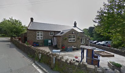
| Description | : | Now a private residence, The primitive Methodist Tabernacle at Bugsworth was founded earlier than 1841 but this is when the first Chapel was built on this site. Rebuilt later because of problems with subsidence. Known locally as The Prims in the early 1980's it was closed and sold. |
frequently asked questions (FAQ):
-
Where is Primitive Methodist Chapel 1841?
Primitive Methodist Chapel 1841 is located at Buxworth, High Peak Borough ,Derbyshire ,England.
-
Primitive Methodist Chapel 1841 cemetery's updated grave count on graveviews.com?
0 memorials
-
Where are the coordinates of the Primitive Methodist Chapel 1841?
Latitude: 53.3363378
Longitude: -1.9667282
Nearby Cemetories:
1. Buxworth Primitive Methodist Churchyard
Chinley, High Peak Borough, England
Coordinate: 53.3364680, -1.9662910
2. St. James Churchyard
Buxworth, High Peak Borough, England
Coordinate: 53.3362500, -1.9688500
3. St. James Churchyard
Whaley Bridge, High Peak Borough, England
Coordinate: 53.3153270, -1.9918840
4. White Knowle Methodist Chapel
Chinley, High Peak Borough, England
Coordinate: 53.3427389, -1.9242500
5. Chinley Independent Chapelyard
Chapel-en-le-Frith, High Peak Borough, England
Coordinate: 53.3349830, -1.9182290
6. Fernilee Methodist Church
Fernilee, High Peak Borough, England
Coordinate: 53.3072690, -1.9752940
7. St Thomas A Beckett Churchyard
Chapel-en-le-Frith, High Peak Borough, England
Coordinate: 53.3243340, -1.9148240
8. St. George's Churchyard
New Mills, High Peak Borough, England
Coordinate: 53.3658550, -1.9940870
9. Town End Methodist Churchyard
Chapel-en-le-Frith, High Peak Borough, England
Coordinate: 53.3246590, -1.9090850
10. New Mills Wesleyan Cemetery
New Mills, High Peak Borough, England
Coordinate: 53.3693695, -1.9974647
11. Church of the Annunciation St Mary's Catholic
New Mills, High Peak Borough, England
Coordinate: 53.3664315, -2.0050768
12. Mount Pleasant Methodist Free Chapel
New Mills, High Peak Borough, England
Coordinate: 53.3683310, -2.0012190
13. Thornsett Cemetery
New Mills, High Peak Borough, England
Coordinate: 53.3777150, -1.9873620
14. Hayfield Cemetery
Hayfield, High Peak Borough, England
Coordinate: 53.3787660, -1.9527010
15. St. Matthew's Churchyard
Hayfield, High Peak Borough, England
Coordinate: 53.3794310, -1.9461140
16. Saint Mary's Parish Church
Disley, Cheshire East Unitary Authority, England
Coordinate: 53.3574410, -2.0397980
17. St Paul Churchyard
Dove Holes, High Peak Borough, England
Coordinate: 53.3007950, -1.8859330
18. Dove Holes Methodist Churchyard
Dove Holes, High Peak Borough, England
Coordinate: 53.2975100, -1.8878900
19. St. John the Evangelist Churchyard
Cheshire East Unitary Authority, England
Coordinate: 53.2862960, -2.0256440
20. St. Thomas Churchyard
Mellor, Metropolitan Borough of Stockport, England
Coordinate: 53.3970440, -2.0277450
21. St. Christopher Churchyard
Pott Shrigley, Cheshire East Unitary Authority, England
Coordinate: 53.3096500, -2.0842900
22. All Saints Churchyard
Marple, Metropolitan Borough of Stockport, England
Coordinate: 53.3889850, -2.0597220
23. Wesleyan Chapel Chapelyard
Rainow, Cheshire East Unitary Authority, England
Coordinate: 53.2835470, -2.0709590
24. St Peter's Churchyard
Fairfield, High Peak Borough, England
Coordinate: 53.2642220, -1.9012830