
| Memorials | : | 0 |
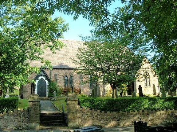
| Location | : | Buxworth, High Peak Borough, England |
| Coordinate | : | 53.3362500, -1.9688500 |
| Description | : | The village was originally called Bugsworth, from the Old English Bucga's Worth ("Bucga's Enclosure"),but in the early 20th century some residents began to dislike the name of their village; their cause was championed by the local vicar, Dr J R Towers, and the village school headmaster, Mr W T Prescott. As a result of the efforts of these two residents, Bugsworth officially became Buxworth on 16 April 1930. No regard was paid to the ancient origins of the village name, which can be traced back to Norman times. |
frequently asked questions (FAQ):
-
Where is St. James Churchyard?
St. James Churchyard is located at Buxworth, High Peak Borough ,Derbyshire , SK23 7NHEngland.
-
St. James Churchyard cemetery's updated grave count on graveviews.com?
0 memorials
-
Where are the coordinates of the St. James Churchyard?
Latitude: 53.3362500
Longitude: -1.9688500
Nearby Cemetories:
1. Primitive Methodist Chapel 1841
Buxworth, High Peak Borough, England
Coordinate: 53.3363378, -1.9667282
2. Buxworth Primitive Methodist Churchyard
Chinley, High Peak Borough, England
Coordinate: 53.3364680, -1.9662910
3. St. James Churchyard
Whaley Bridge, High Peak Borough, England
Coordinate: 53.3153270, -1.9918840
4. White Knowle Methodist Chapel
Chinley, High Peak Borough, England
Coordinate: 53.3427389, -1.9242500
5. Fernilee Methodist Church
Fernilee, High Peak Borough, England
Coordinate: 53.3072690, -1.9752940
6. Chinley Independent Chapelyard
Chapel-en-le-Frith, High Peak Borough, England
Coordinate: 53.3349830, -1.9182290
7. St. George's Churchyard
New Mills, High Peak Borough, England
Coordinate: 53.3658550, -1.9940870
8. St Thomas A Beckett Churchyard
Chapel-en-le-Frith, High Peak Borough, England
Coordinate: 53.3243340, -1.9148240
9. Church of the Annunciation St Mary's Catholic
New Mills, High Peak Borough, England
Coordinate: 53.3664315, -2.0050768
10. New Mills Wesleyan Cemetery
New Mills, High Peak Borough, England
Coordinate: 53.3693695, -1.9974647
11. Mount Pleasant Methodist Free Chapel
New Mills, High Peak Borough, England
Coordinate: 53.3683310, -2.0012190
12. Town End Methodist Churchyard
Chapel-en-le-Frith, High Peak Borough, England
Coordinate: 53.3246590, -1.9090850
13. Thornsett Cemetery
New Mills, High Peak Borough, England
Coordinate: 53.3777150, -1.9873620
14. Hayfield Cemetery
Hayfield, High Peak Borough, England
Coordinate: 53.3787660, -1.9527010
15. St. Matthew's Churchyard
Hayfield, High Peak Borough, England
Coordinate: 53.3794310, -1.9461140
16. Saint Mary's Parish Church
Disley, Cheshire East Unitary Authority, England
Coordinate: 53.3574410, -2.0397980
17. St. John the Evangelist Churchyard
Cheshire East Unitary Authority, England
Coordinate: 53.2862960, -2.0256440
18. St Paul Churchyard
Dove Holes, High Peak Borough, England
Coordinate: 53.3007950, -1.8859330
19. Dove Holes Methodist Churchyard
Dove Holes, High Peak Borough, England
Coordinate: 53.2975100, -1.8878900
20. St. Thomas Churchyard
Mellor, Metropolitan Borough of Stockport, England
Coordinate: 53.3970440, -2.0277450
21. St. Christopher Churchyard
Pott Shrigley, Cheshire East Unitary Authority, England
Coordinate: 53.3096500, -2.0842900
22. All Saints Churchyard
Marple, Metropolitan Borough of Stockport, England
Coordinate: 53.3889850, -2.0597220
23. Wesleyan Chapel Chapelyard
Rainow, Cheshire East Unitary Authority, England
Coordinate: 53.2835470, -2.0709590
24. St Peter's Churchyard
Fairfield, High Peak Borough, England
Coordinate: 53.2642220, -1.9012830