
| Memorials | : | 0 |
| Location | : | Helmsley, Ryedale District, England |
| Coordinate | : | 54.2449170, -1.0639570 |
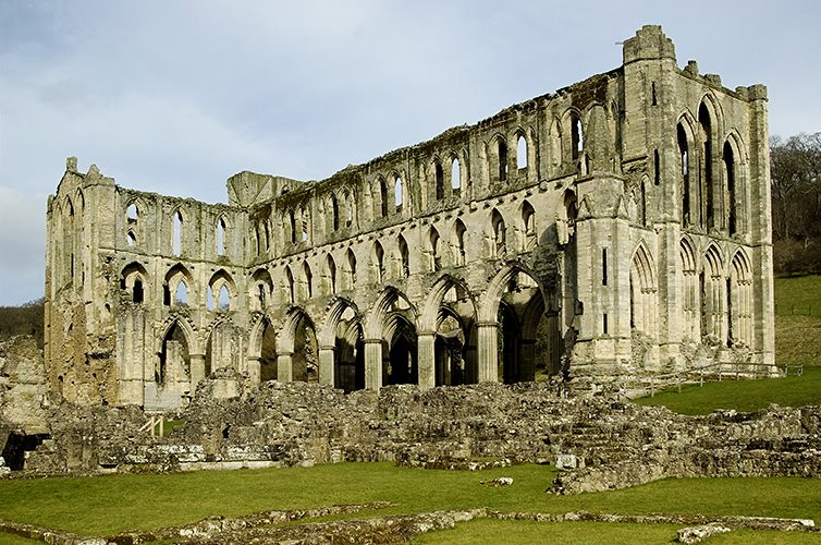
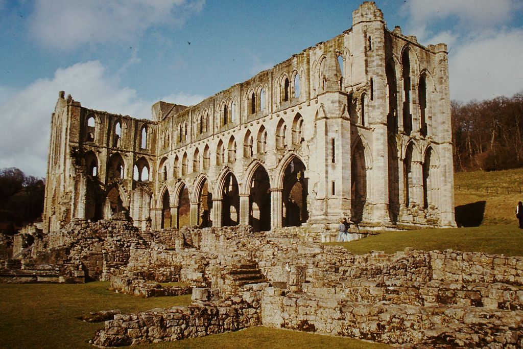
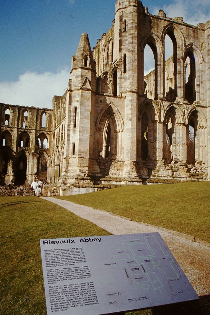
| Description | : | Rievaulx Abbey /ri¢°ˈvoʊ/ ree-VOH is a former Cistercian abbey in Rievaulx, near Helmsley in the North York Moors National Park, North Yorkshire, England. Headed by the Abbot of Rievaulx, it was one of the wealthiest abbeys in England until it was dissolved by Henry VIII of England in 1538. Its ruins are a tourist attraction, owned and maintained by English Heritage.Rievaulx Abbey was founded in 1132 by twelve monks from Clairvaux Abbey as a mission for the colonisation of the north of England and Scotland. It was the first Cistercian abbey in the north. |
frequently asked questions (FAQ):
-
Where is Rievaulx Abbey?
Rievaulx Abbey is located at Helmsley, Ryedale District ,North Yorkshire , YO62 5LBEngland.
-
Rievaulx Abbey cemetery's updated grave count on graveviews.com?
0 memorials
-
Where are the coordinates of the Rievaulx Abbey?
Latitude: 54.2449170
Longitude: -1.0639570
Nearby Cemetories:
1. All Saints Churchyard
Helmsley, Ryedale District, England
Coordinate: 54.2469000, -1.0625000
2. Helmsley Town Cemetery
Helmsley, Ryedale District, England
Coordinate: 54.2483300, -1.0620300
3. Harome Village Cemetery
Harome, Ryedale District, England
Coordinate: 54.2308650, -1.0096380
4. St Saviour Churchyard
Harome, Ryedale District, England
Coordinate: 54.2302000, -1.0088000
5. St Oswald Churchyard
Oswaldkirk, Ryedale District, England
Coordinate: 54.2022340, -1.0495510
6. Ampleforth Abbey - Monk's Wood
Ampleforth, Ryedale District, England
Coordinate: 54.2028689, -1.0841344
7. Ampleforth Abbey
Ampleforth, Ryedale District, England
Coordinate: 54.2019630, -1.0838000
8. Our Lady & St Benedict RC Churchyard
Ampleforth, Ryedale District, England
Coordinate: 54.2009700, -1.1055400
9. St Hilda Churchyard
Ampleforth, Ryedale District, England
Coordinate: 54.2000630, -1.1075590
10. Ampleforth Friends Burial Ground
Ampleforth, Ryedale District, England
Coordinate: 54.2023420, -1.1213330
11. Saint Mary’s Churchyard
Scawton, Ryedale District, England
Coordinate: 54.2451000, -1.1591000
12. All Saints Churchyard
Old Byland, Ryedale District, England
Coordinate: 54.2663000, -1.1558000
13. Gilling New Churchyard
Gilling East, Ryedale District, England
Coordinate: 54.1856070, -1.0559535
14. Holy Cross Churchyard
Gilling East, Ryedale District, England
Coordinate: 54.1841290, -1.0580460
15. St Gregory Minster Churchyard Extension
Nawton, Ryedale District, England
Coordinate: 54.2628100, -0.9629100
16. St. Gregory's Minster Churchyard
Kirkdale, Ryedale District, England
Coordinate: 54.2628300, -0.9622613
17. St Gregory Minster Churchyard
Nawton, Ryedale District, England
Coordinate: 54.2627570, -0.9621910
18. All Saints and St James Church
Nunnington, Ryedale District, England
Coordinate: 54.2031000, -0.9806000
19. Stonegrave Minster Churchyard
Stonegrave, Ryedale District, England
Coordinate: 54.1925011, -0.9966000
20. Byland Abbey
Coxwold, Hambleton District, England
Coordinate: 54.2034480, -1.1589660
21. St Michael Churchyard
Cold Kirby, Ryedale District, England
Coordinate: 54.2534580, -1.1827120
22. All Saints Churchyard
Kirkbymoorside, Ryedale District, England
Coordinate: 54.2703470, -0.9310110
23. St. Michael and All Angels Churchyard
Edstone, Ryedale District, England
Coordinate: 54.2469000, -0.9188000
24. Hovingham Cemetery
Hovingham, Ryedale District, England
Coordinate: 54.1753500, -0.9808900